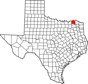
مقاطعة لامار، تكساس
(تم التحويل من Lamar County, Texas)
Lamar County | |
|---|---|
 The Lamar County Courthouse in Paris | |
 الموقع ضمن ولاية Texas | |
 موقع Texas ضمن الولايات المتحدة | |
| الإحداثيات: 33°40′N 95°34′W / 33.67°N 95.57°W | |
| البلد | |
| State | |
| تأسست | 1841 |
| السمِيْ | Mirabeau Buonaparte Lamar |
| Seat | Paris |
| أكبر مدينة | Paris |
| المساحة | |
| • الإجمالي | 933 ميل² (2٬420 كم²) |
| • البر | 907 ميل² (2٬350 كم²) |
| • الماء | 26 ميل² (70 كم²) 2.8%% |
| التعداد (2010) | |
| • الإجمالي | 49٬891 |
| • Estimate (2019) | 49٬859 |
| منطقة التوقيت | UTC−6 (Central) |
| • الصيف (التوقيت الصيفي) | UTC−5 (CDT) |
| Congressional district | 4th |
| الموقع الإلكتروني | www |
مقاطعة لامار إنگليزية: Lamar County هي إحدى المقاطعات في ولاية تكساس، الولايات المتحدة الأمريكية.
الجغرافيا
According to the U.S. Census Bureau, the county has a total area of 933 ميل مربع (2،420 km2), of which 907 ميل مربع (2،350 km2) are land and 26 ميل مربع (67 km2) (2.8%) are covered by water.[1]
Major highways
المقاطعات المجاورة
- Choctaw County, Oklahoma (north)
- Red River County (east)
- Delta County (south)
- Fannin County (west)
- Bryan County, Oklahoma (northwest)
السكان
| التعداد | Pop. | ملاحظة | %± |
|---|---|---|---|
| 1850 | 3٬978 | — | |
| 1860 | 10٬136 | 154٫8% | |
| 1870 | 15٬790 | 55٫8% | |
| 1880 | 27٬193 | 72٫2% | |
| 1890 | 37٬302 | 37٫2% | |
| 1900 | 48٬627 | 30٫4% | |
| 1910 | 46٬544 | −4٫3% | |
| 1920 | 55٬742 | 19٫8% | |
| 1930 | 48٬529 | −12٫9% | |
| 1940 | 50٬425 | 3٫9% | |
| 1950 | 43٬033 | −14٫7% | |
| 1960 | 34٬234 | −20٫4% | |
| 1970 | 36٬062 | 5٫3% | |
| 1980 | 42٬156 | 16٫9% | |
| 1990 | 43٬949 | 4٫3% | |
| 2000 | 48٬499 | 10٫4% | |
| 2010 | 49٬793 | 2٫7% | |
| 2019 (تق.) | 49٬859 | [2] | 0٫1% |
| U.S. Decennial Census[3] 1850–2010[4] 2010–2014[5] | |||
Communities
Cities
- Blossom
- Deport (partly in Red River County)
- Paris (county seat)
- Reno
- Roxton
- Sun Valley
- Toco
Census-designated place
Unincorporated communities
Politics
Presidential elections results
| Year | Republican | Democratic | Third parties |
|---|---|---|---|
| 2016 | 78.2% 14,561 | 19.3% 3,583 | 2.5% 467 |
| 2012 | 74.6% 12,826 | 24.3% 4,181 | 1.1% 190 |
| 2008 | 70.5% 12,952 | 28.6% 5,243 | 0.9% 167 |
| 2004 | 69.0% 12,054 | 30.6% 5,338 | 0.5% 78 |
| 2000 | 63.4% 9,775 | 36.0% 5,553 | 0.7% 102 |
| 1996 | 46.6% 6,393 | 44.3% 6,075 | 9.1% 1,254 |
| 1992 | 35.6% 5,778 | 39.0% 6,328 | 25.5% 4,137 |
| 1988 | 51.4% 8,021 | 48.4% 7,553 | 0.2% 24 |
| 1984 | 62.6% 9,273 | 37.1% 5,504 | 0.3% 43 |
| 1980 | 45.2% 6,094 | 53.2% 7,178 | 1.6% 218 |
| 1976 | 34.0% 4,443 | 65.8% 8,601 | 0.2% 32 |
| 1972 | 72.6% 7,736 | 26.9% 2,865 | 0.5% 51 |
| 1968 | 31.1% 3,395 | 42.4% 4,635 | 26.6% 2,903 |
| 1964 | 29.1% 2,594 | 70.8% 6,303 | 0.1% 8 |
| 1960 | 43.7% 3,964 | 56.0% 5,084 | 0.3% 28 |
| 1956 | 49.6% 4,154 | 50.1% 4,202 | 0.3% 25 |
| 1952 | 41.6% 3,929 | 58.4% 5,524 | |
| 1948 | 12.2% 1,018 | 75.4% 6,306 | 12.4% 1,041 |
| 1944 | 9.4% 725 | 81.1% 6,283 | 9.5% 739 |
| 1940 | 8.6% 761 | 91.3% 8,038 | 0.1% 6 |
| 1936 | 5.2% 308 | 94.7% 5,621 | 0.2% 10 |
| 1932 | 6.0% 375 | 93.7% 5,911 | 0.3% 21 |
| 1928 | 57.1% 2,887 | 42.8% 2,163 | 0.2% 8 |
| 1924 | 10.0% 596 | 87.4% 5,224 | 2.7% 159 |
| 1920 | 12.8% 639 | 75.2% 3,765 | 12.0% 602 |
| 1916 | 8.1% 309 | 89.2% 3,412 | 2.7% 103 |
| 1912 | 7.5% 206 | 82.9% 2,286 | 9.7% 266 |
See also
- National Register of Historic Places listings in Lamar County, Texas
- Recorded Texas Historic Landmarks in Lamar County
- Lamar County Historical Museum
الهامش
- ^ "2010 Census Gazetteer Files". United States Census Bureau. August 22, 2012. Retrieved May 3, 2015.
- ^ "Population and Housing Unit Estimates". United States Census Bureau. May 24, 2020. Retrieved May 27, 2020.
- ^ "U.S. Decennial Census". United States Census Bureau. Retrieved May 3, 2015.
- ^ "Texas Almanac: Population History of Counties from 1850–2010" (PDF). Texas Almanac. Retrieved May 3, 2015.
- ^ خطأ استشهاد: وسم
<ref>غير صحيح؛ لا نص تم توفيره للمراجع المسماةQF - ^ Leip, David. "Dave Leip's Atlas of U.S. Presidential Elections". uselectionatlas.org. Retrieved 2018-07-26.
وصلات خارجية
 Media related to Lamar County, Texas at Wikimedia Commons
- Lamar County government's website
- Lamar County in Handbook of Texas Online at the University of Texas
- Historic Lamar County materials, hosted by the Portal to Texas History
- Lamar County Texas information - Lamar County Station

|
Choctaw County, Oklahoma | Bryan County, Oklahoma | 
| |
| Red River County | Fannin County | |||
| Delta County |
?
تصنيفات:
- Pages using gadget WikiMiniAtlas
- Short description is different from Wikidata
- Coordinates on Wikidata
- مقاطعات Texas
- Pages using infobox U.S. county with unknown parameters
- Articles containing إنگليزية-language text
- Pages using Lang-xx templates
- Pages using US Census population needing update
- Pages with empty portal template
- Lamar County, Texas
- 1841 establishments in the Republic of Texas
- Populated places established in 1841
- مقاطعات تكساس
