مقاطعة بايات، إلينوي
بايات | |
|---|---|
| الموقع ضمن ولاية Illinois الموقع ضمن ولاية Illinois | |
 موقع Illinois ضمن الولايات المتحدة | |
| الإحداثيات: 40°01′N 88°35′W / 40.01°N 88.59°W | |
| البلد | |
| State | |
| تأسست | 1841 |
| Seat | Monticello |
| أكبر مدينة | Monticello |
| التعداد (2000) | |
| • الإجمالي | 16٬365 |
| منطقة التوقيت | UTC−6 (Central) |
| • الصيف (التوقيت الصيفي) | UTC−5 (CDT) |
| الموقع الإلكتروني | www |
مقاطعة پايات إنگليزية: Piatt County هي إحدى المقاطعات في ولاية إلينوي في الولايات المتحدة.
المناخ
| مونتيسلو، إلينوي | ||||||||||||||||||||||||||||||||||||||||||||||||||||||||||||
|---|---|---|---|---|---|---|---|---|---|---|---|---|---|---|---|---|---|---|---|---|---|---|---|---|---|---|---|---|---|---|---|---|---|---|---|---|---|---|---|---|---|---|---|---|---|---|---|---|---|---|---|---|---|---|---|---|---|---|---|---|
| جدول الطقس (التفسير) | ||||||||||||||||||||||||||||||||||||||||||||||||||||||||||||
| ||||||||||||||||||||||||||||||||||||||||||||||||||||||||||||
| ||||||||||||||||||||||||||||||||||||||||||||||||||||||||||||
In recent years, average temperatures in the county seat of Monticello have ranged from a low of 14 °F (−10 °C) in January to a high of 85 °F (29 °C) in July, although a record low of −25 °F (−32 °C) was recorded in January 1999 and a record high of 105 °F (41 °C) was recorded in July 1966. Average monthly precipitation ranged from 1.61 بوصات (41 mm) in January to 3.99 بوصات (101 mm) in August.[1]
الطرق الرئيسية
المقاطعات المجاورة
- McLean County - north
- Champaign County - east
- Douglas County - southeast
- Moultrie County - south
- Macon County - southwest
- De Witt County - west
الديمغرافيا
| التعداد | Pop. | ملاحظة | %± |
|---|---|---|---|
| 1850 | 1٬606 | — | |
| 1860 | 6٬127 | 281٫5% | |
| 1870 | 10٬953 | 78٫8% | |
| 1880 | 15٬583 | 42٫3% | |
| 1890 | 17٬062 | 9٫5% | |
| 1900 | 17٬706 | 3٫8% | |
| 1910 | 16٬376 | −7٫5% | |
| 1920 | 15٬714 | −4�0% | |
| 1930 | 15٬588 | −0٫8% | |
| 1940 | 14٬659 | −6�0% | |
| 1950 | 13٬970 | −4٫7% | |
| 1960 | 14٬960 | 7٫1% | |
| 1970 | 15٬509 | 3٫7% | |
| 1980 | 16٬581 | 6٫9% | |
| 1990 | 15٬548 | −6٫2% | |
| 2000 | 16٬365 | 5٫3% | |
| 2010 | 16٬729 | 2٫2% | |
| 2013 (تق.) | 16٬433 | −1٫8% | |
| U.S. Decennial Census[2] 1790-1960[3] 1900-1990[4] 1990-2000[5] 2010-2013[6] | |||
تجمعات سكنية
المدينة
القرى
بلدات غير مشهرة
أماكن سابقة
- Blue Ridge
- Centerville
- Combs
- Harris
- Unity
- Voorhies
- Willow Branch
البلدات
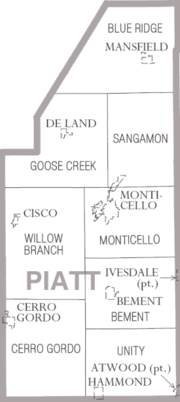
Piatt County is divided into eight البلدات:
انظر أيضاً
الهامش
- ^ أ ب "Monthly Averages for Monticello, Illinois". The Weather Channel. Retrieved 2011-01-27.
- ^ "U.S. Decennial Census". United States Census Bureau. Retrieved July 8, 2014.
- ^ "Historical Census Browser". University of Virginia Library. Retrieved July 8, 2014.
- ^ "Population of Counties by Decennial Census: 1900 to 1990". United States Census Bureau. Retrieved July 8, 2014.
- ^ "Census 2000 PHC-T-4. Ranking Tables for Counties: 1990 and 2000" (PDF). United States Census Bureau. Retrieved July 8, 2014.
- ^ خطأ استشهاد: وسم
<ref>غير صحيح؛ لا نص تم توفيره للمراجع المسماةQF

|
McLean County | 
| ||
| Champaign County | De Witt County | |||
| Douglas County | Moultrie County | Macon County |
الكلمات الدالة:
?
تصنيفات:
- Pages using gadget WikiMiniAtlas
- Short description is different from Wikidata
- مقاطعات Illinois
- U.S. Counties Missing Ex Image
- Pages using infobox U.S. county with unknown parameters
- Pages using infobox U.S. county with a missing map
- Articles containing إنگليزية-language text
- Pages using Lang-xx templates
- Pages using US Census population needing update
- Portal-inline template with redlinked portals
- Pages with empty portal template
- Coordinates on Wikidata
- تأسيسات 1841 في الولايات المتحدة
- Populated places established in 1841
- Piatt County, Illinois
- مقاطعات إلينوي
