كوروسا
كوروسا
Kouroussa | |
|---|---|
Sub-prefecture and town | |
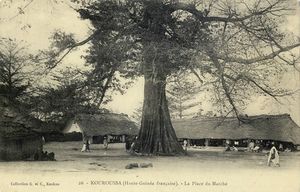
 Kouroussa market square, seen in a French image from 1911 | |
| الإحداثيات: 10°39′00″N 09°53′00″W / 10.65000°N 9.88333°W | |
| البلد | |
| المنطقة | منطقة كنكن |
| المحافظة | محافظة كوروسا |
| المنسوب | 362 m (1٬188 ft) |
| التعداد (2014) | |
| • الإجمالي | 39٬611 |
| منطقة التوقيت | UTC0 |
كوروسا Kouroussa أو Kurussa هي بلدة تقع في شمال شرق غينيا، وهي عاصمة محافظة كوروسا. وحتى 2014 بلغ عدد سكانها 39,611 نسمة.[1] A trade center and river port from at least the time of the Mali Empire, Kouroussa has long relied upon its position near the upstream limit of navigation of the Niger River to make it an important crossroads for people and goods moving between the Guinea coast and the states of the western Soudan and Niger River valley. The town and surrounding area is a center of Malinke culture, and is known for its Djembe drumming tradition.
التاريخ
Kouroussa represented the southern end of the Manden: the Mandé heartland of the امبراطورية مالي. Kouroussa's position as a river port has made it a historic center for regional trade, much like its larger neighbor Kankan. Much of the Jallonke population of the area migrated from the west when the Fula people conquered the Fouta Djallon in the 13th - 16th centuries. With the collapse of the empire, southern Manden confederations and states continued to exist, including in the area around Kouroussa. In the 17th century the Fama Da Monzon Diarra of the Bambara Empire made Kouroussa the southern reach of his state. By the 18th century the Fula Muslim Imamate of Futa Jallon led by the Alamay of Timbo provided pressure from the south and west, while the growing Kong state (in modern Côte d'Ivoire) became powerful to the south and east. The Mandé state around Kouroussa, called in some periods Hamana and in others Koumara, continued as an important trade center and small regional power, squeezed between these forces.[2]
أشخاص بارزون
- كمارا لايه -كاتب
انظر أيضاً
المراجع
- ^ "Guinea". Institut National de la Statistique, Guinea, accessed via Geohive. Archived from the original on 24 November 2015. Retrieved 12 September 2014.
{{cite web}}: Unknown parameter|deadurl=ignored (|url-status=suggested) (help) - ^ Jan Jansen. THE REPRESENTATION OF STATUS IN MANDE: DID THE MALIEMPIRE STILL EXIST IN THE NINETEENTH CENTURY? History in Africa 23 (1996), 87-109
Note: Jansen argues for a reappraisal of Mandé dating which pushes remnants of the Mali Empire into the 19th century. The more traditional dates are accepted in Charlotte A Quinn. Mandingo kingdoms of the Senegambia: Traditionalism, Islam, and European expansion. Longman (1972). ISBN 0-582-64547-6

