إعصار إستوائي
| أعاصير إستوائية |
| التكون والتسمية |
|---|
| التطور - البنية التسمية - القوائم الإستوائية - القائمة الكاملة |
| التأثيرات |
|
التأثيرات |
| علم المناخ والتتبع |
| الأحواض - RSMCs - TCWCs - المقاييس المراقبة - التوقع توقع الأمطار علم مناخ سقوط الأمطار |
| جزء من سلسلة الطبيعة: الطقس |
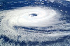
الإعصار الاستوائي هو نظام عاصفة يتميز بمركز منخفض الضغط وعدد كبير من العواصف الرعدية التي تؤدي إلى رياح قوية وأمطار فيضانات.
. . . . . . . . . . . . . . . . . . . . . . . . . . . . . . . . . . . . . . . . . . . . . . . . . . . . . . . . . . . . . . . . . . . . . . . . . . . . . . . . . . . . . . . . . . . . . . . . . . . . . . . . . . . . . . . . . . . . . . . . . . . . . . . . . . . . . . . . . . . . . . . . . . . . . . . . . . . . . . . . . . . . . . . .
البنية الطبيعية
العين والمركز
| Size descriptions of tropical cyclones | |
|---|---|
| ROCI | النوع |
| Less than 2 degrees latitude | Very small/midget |
| 2 to 3 degrees of latitude | Small |
| 3 to 6 degrees of latitude | Medium/Average |
| 6 to 8 degrees of latitude | Large |
| Over 8 degrees of latitude | Very large[1] |
الحجم
الميكانيكا

الأحواض الرئيسية ومراكز الإنذار المناظرة
| ||||||||||||||||||||||
|
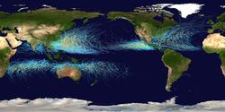
التكون
المرات
| Season lengths and seasonal averages[4][5] | |||||
|---|---|---|---|---|---|
| Basin | Season start | Season end | Tropical Storms (>34 knots) |
Tropical Cyclones (>63 knots) |
Category 3+ TCs (>95 knots) |
| Northwest Pacific | April | January | 26.7 | 16.9 | 8.5 |
| South Indian | November | April | 20.6 | 10.3 | 4.3 |
| Northeast Pacific | May | November | 16.3 | 9.0 | 4.1 |
| North Atlantic | June | November | 10.6 | 5.9 | 2.0 |
| Australia Southwest Pacific | November | April | 10.6 | 4.8 | 1.9 |
| North Indian | April | December | 5.4 | 2.2 | 0.4 |
العوامل
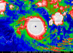
الحركة والمسار
Steering winds
Coriolis effect
. . . . . . . . . . . . . . . . . . . . . . . . . . . . . . . . . . . . . . . . . . . . . . . . . . . . . . . . . . . . . . . . . . . . . . . . . . . . . . . . . . . . . . . . . . . . . . . . . . . . . . . . . . . . . . . . . . . . . . . . . . . . . . . . . . . . . . . . . . . . . . . . . . . . . . . . . . . . . . . . . . . . . . . .
التفاعل مع the mid-latitude westerlies
التشتت
العوامل
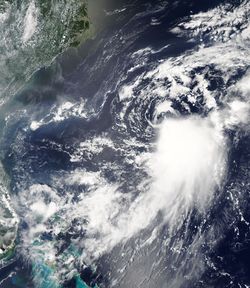
التأثيرات

الرصد والتنبؤ
الرصد

التنبؤ
التصنيفات والمصطلحات والتسمية
تصنيفات الشدة

أصول تعبيرات العواصف

أهم الأعاصير الإستوائية

. . . . . . . . . . . . . . . . . . . . . . . . . . . . . . . . . . . . . . . . . . . . . . . . . . . . . . . . . . . . . . . . . . . . . . . . . . . . . . . . . . . . . . . . . . . . . . . . . . . . . . . . . . . . . . . . . . . . . . . . . . . . . . . . . . . . . . . . . . . . . . . . . . . . . . . . . . . . . . . . . . . . . . . .
أنواع أعاصير ذات علاقة
انظر أيضاً
- Hurricane Alley
- Hypercane
- List of wettest tropical cyclones by country
- Secondary flow in tropical cyclones
|
|
المصادر
- ^ Joint Typhoon Warning Center. Q: What is the average size of a tropical cyclone? Retrieved on 2007-07-04.
- ^ Kerry Emanuel. Anthropogenic Effects on Tropical Cyclone Activity. Retrieved on 2008-02-25.
- ^ Atlantic Oceanographic and Meteorological Laboratory, Hurricane Research Division. "Frequently Asked Questions: What regions around the globe have tropical cyclones and who is responsible for forecasting there?". NOAA. Retrieved 2006-07-25.
- ^ خطأ استشهاد: وسم
<ref>غير صحيح؛ لا نص تم توفيره للمراجع المسماةAOML FAQ G1 - ^ Atlantic Oceanographic and Meteorological Laboratory, Hurricane Research Division. "Frequently Asked Questions: What are the average, most, and least tropical cyclones occurring in each basin?". NOAA. Retrieved 2006-11-30.
وصلات خارجية
| Tropical cyclones
]].- مراجع تعليمية
- Economic Costs of Hurricanes and associated Economic Benefits from Improved Forecasting
- FEMA for Kids: Hurricanes
- Mariner's Guide for Hurricane AwarenessPDF (1.23 MiB)
- Is Global Climate Change Affecting Hurricanes?
- NOVA science now: Hurricanes
- Surviving a hurricane – A guide for children and youth
- Summary of cyclone terminology from NOAA FAQ
- Tropical Storms Worldwide – by Hawaii University
- WMO guide on cyclone terminology
- World Meteorological Organization Severe Weather Information Center – Shows all current tropical systems worldwide and their tracks
- Regional specialised meteorological centers
- Canadian Hurricane Centre - Canadian Maritimes
- Caribbean Disaster Emergency Response Agency - Caribbean region
- Caribbean Hurricane Network - Caribbean region
- Central Pacific Hurricane Center – Central Pacific
- Fiji Meteorological Service – South Pacific east of 160°, north of 25° S
- India Meteorological Department – Bay of Bengal and the Arabian Sea
- Japan Meteorological Agency – NW Pacific
- Météo-France – La Reunion – South Indian Ocean from Africa to 90° E
- US National Hurricane Center – North Atlantic, Eastern Pacific
- عواصف سابقة
- Digital Typhoon: Typhoon Images and Information
- Global climatology of tropical cyclones
- Global ISCCP B1 Browse System Satellite Archive- by ISCCP
- Unisys historical and contemporary hurricane track data
- United States Tropical Cyclone Rainfall Climatology – Nearly 30 years of tropical cyclone histories with an emphasis on storm total rainfall, in color, up to present. Broken up by year, region, by point of landfall, and North American countries impacted
- Interactive hurricane tracking map - Includes hurricane data all the way back to the 1850s

