حلقة شيكاغو
The Loop | |
|---|---|
| Community Area 32 – The Loop | |
 | |
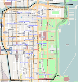
 Streetmap | |
 Location within the city of Chicago | |
| الإحداثيات: 41°53′N 87°38′W / 41.883°N 87.633°W | |
| Country | الولايات المتحدة |
| State | Illinois |
| County | Cook |
| City | Chicago |
| Neighborhoods | |
| المساحة | |
| • الإجمالي | 1٫58 ميل² (4٫09 كم²) |
| التعداد (2015) | |
| • الإجمالي | 33٬442[1] |
| (population up 104.1% from 2000) | |
| Demographics 2015[1] | |
| • White | 60.94% |
| • Black | 12.35% |
| • Hispanic | 6.45% |
| • Asian | 17.14% |
| • Other | 3.12% |
| Educational Attainment 2015[1] | |
| • High School Diploma or Higher | 92.8% |
| • Bachelor's Degree or Higher | 78.8% |
| منطقة التوقيت | UTC-6 (CST) |
| • الصيف (التوقيت الصيفي) | UTC-5 (CDT) |
| ZIP codes | 60601, 60602, 60603, 60604, and parts of 60605, 60606, 60607, and 60616 |
| Median household income | $93,254[1] |
| Source: U.S. Census, Record Information Services [مطلوب توضيح] | |
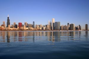
الحلقة أو لوپ Loop، هي واحدة من 77 مجاورة معينة في شيكاغو، وهي central business district في منطقة downtown في المدينة. It is home to Chicago's commercial core, City Hall, وهي مقر مقاطعة كوك. Bounded on the north and west by the Chicago River, on the east by Lake Michigan, and on the south by Roosevelt Road (although the commercial core has expanded into adjacent community areas), it is the second largest commercial business district in the United States after Midtown Manhattan and contains the headquarters of many locally and globally important businesses as well as many of Chicago's most famous attractions.
In what is now the Loop, on the south bank of the Chicago River near today's Michigan Avenue Bridge, the United States Army erected Fort Dearborn in 1803, the first settlement in the area sponsored by the United States. In the late nineteenth century cable car turnarounds and a prominent elevated railway encircled the area, giving the Loop its name. Around the same time some of the world's earliest skyscrapers were constructed in the area. In 1908, Chicago addresses were made uniform by naming the intersection of State Street and Madison Street in the Loop as the origin of the Chicago street grid.
انظر أيضاً
المراجع
- ^ أ ب ت ث "Community Data Snapshot - Loop" (PDF). cmap.illinois.gov. MetroPulse. Retrieved ديسمبر 1, 2017.
وصلات خارجية
 Chicago Loop travel guide from Wikivoyage
- Loop Alliance
- Greater South Loop Association
- Prairie District Neighborhood Alliance Website
- City of Chicago Loop Community Map
- Rand McNally 1893 Loop Sketches

|
Near North Side | West Town | 
| |
| Lake Michigan | Near West Side | |||
| Near South Side |
- Pages using gadget WikiMiniAtlas
- Use mdy dates from October 2012
- Short description is different from Wikidata
- Coordinates on Wikidata
- جميع الصفحات التي تحتاج تنظيف
- مقالات بالمعرفة تحتاج توضيح from March 2009
- مناطق الأعمال المركزية في الولايات المتحدة
- Central Chicago
- Community areas of Chicago
- Geography of Chicago
- Shopping centers in Chicago