أيداهو
Idaho | |
|---|---|
| الكنية: The Gem State (official), The Potato State | |
| الشعار: | |
| النشيد: "Here We Have Idaho" | |
 خريطة الولايات المتحدة، موضح فيها Idaho | |
| البلد | الولايات المتحدة |
| قبل الولائية | Oregon Territory, Washington Territory, Idaho Territory |
| انضمت للاتحاد | July 3, 1890 (43rd) |
| العاصمة (وأكبر مدينة) | Boise |
| الحكومة | |
| • الحاكم | Brad Little (R) |
| • نائب الحاكم | Scott Bedke (R) |
| المجلس التشريعي | Legislature |
| • المجلس العلوي | Senate |
| • المجلس السفلى | House of Representatives |
| القضاء | Idaho Supreme Court |
| سناتورات الولايات المتحدة | Mike Crapo (R) Jim Risch (R) |
| وفد مجلس النواب | 1. Russ Fulcher (R) 2. Mike Simpson (R) (القائمة) |
| المساحة | |
| • الإجمالي | 83٬546[2] ميل² (216٬444 كم²) |
| • البر | 82٬623 ميل² (216٬400 كم²) |
| • الماء | 923 ميل² (2٬398 كم²) 1.11% |
| ترتيب المساحة | 11th |
| الأبعاد | |
| • الطول | 479 mi (771 km) |
| • العرض | 305 mi (491 km) |
| المنسوب | 5٬000 ft (1٬520 m) |
| أعلى منسوب | 12٬662 ft (3٬859 m) |
| أوطى منسوب | 713 ft (217 m) |
| التعداد | |
| • الإجمالي | 1٬964٬726 |
| • الترتيب | 38th |
| • الكثافة | 23٫63/sq mi (8٫33/km2) |
| • ترتيب الكثافة | 44th |
| • الدخل الأوسط للأسرة | $76٬918[5] |
| • ترتيب الدخل | 31st |
| صفة المواطن | Idahoan |
| اللغة | |
| • اللغة الرسمية | English[6] |
| منطقة التوقيت | |
| primary | UTC−07:00 (Mountain) |
| • الصيف (التوقيت الصيفي) | UTC−06:00 (MDT) |
| Idaho Panhandle | UTC−08:00 (Pacific) |
| • Summer (DST) | UTC−07:00 (PDT) |
| اختصار البريد | ID |
| ISO 3166 code | US-ID |
| خط العرض | 42° N to 49° N |
| خط الطول | 111°03′ W to 117°15′ W |
| الموقع الإلكتروني | idaho |
 علم Idaho | |
 شعار Idaho | |
| رموز حية | |
|---|---|
| البرمائي | Tiger salamander (Ambystoma tigrinum) |
| الطائر |
|
| السمك | Cutthroat trout (Oncorhynchus clarkii) |
| الزهرة | Syringa (Philadelphus lewisii) |
| سلالة الجياد | Appaloosa |
| الحشرة | Monarch butterfly (Danaus plexippus) |
| الشجرة | Western white pine (Pinus monticola) |
| رموز جامدة | |
| الرقصة | Square dance |
| الطعام |
|
| الأحفورة | Hagerman horse (Equus simplicidens) |
| الحجر الكريم | Star garnet |
| التربة | Threebear |
| علامة طريق ولائي | |
 | |
| قوائم رموز الولايات الأمريكية | |
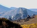
آيداهو Idaho هي ولاية من الولايات المتحدة. وهي إحدى ولايات جبال الروكي بالولايات المتحدة الأمريكية ذات المشاهد الجميلة والموارد الطبيعية الهائلة. بها جبال مرتفعة تغطي قِممَهَا الثلوج، وأنهار سريعة ذات دوامات، وبحيرات هادئة ووديان سحيقة. It shares a small portion of the Canada–United States border to the north, with the province of British Columbia. It borders Montana and Wyoming to the east, Nevada and Utah to the south, and Washington and Oregon to the west. عدد سكانها 1,293,953 نسمة. وأكبر مدن إيداهو مدينة بويزي الواقعة في الجزء الجنوبي الغربي. وهي أيضاً عاصمة الولاية. With an area of 83,570 square miles (216,400 km2), Idaho is the 14th largest state by land area. With a population of approximately 1.8 million, it ranks as the 13th least populous and the 7th least densely populated of the 50 U.S. states.
For thousands of years, and prior to European colonization, Idaho has been inhabited by native peoples. In the early 19th century, Idaho was considered part of the Oregon Country, an area of dispute between the U.S. and the British Empire. It officially became a U.S. territory with the signing of the Oregon Treaty of 1846, but a separate Idaho Territory was not organized until 1863, instead being included for periods in Oregon Territory and Washington Territory. Idaho was eventually admitted to the Union on July 3, 1890, becoming the 43rd state.
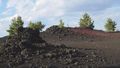
Forming part of the Pacific Northwest (and the associated Cascadia bioregion), Idaho is divided into several distinct geographic and climatic regions. The state's north, the relatively isolated Idaho Panhandle, is closely linked with Eastern Washington, with which it shares the Pacific Time Zone—the rest of the state uses the Mountain Time Zone. The state's south includes the Snake River Plain (which has most of the population and agricultural land), and the southeast incorporates part of the Great Basin. Idaho is quite mountainous and contains several stretches of the Rocky Mountains. The United States Forest Service holds about 38% of Idaho's land, the highest proportion of any state.[7]
Industries significant for the state economy include manufacturing, agriculture, mining, forestry, and tourism. Several science and technology firms are either headquartered in Idaho or have factories there, and the state also contains the Idaho National Laboratory, which is the country's largest Department of Energy facility. Idaho's agricultural sector supplies many products, but the state is best known for its potato crop, which comprises around one-third of the nationwide yield. The official state nickname is the "Gem State."[8]
. . . . . . . . . . . . . . . . . . . . . . . . . . . . . . . . . . . . . . . . . . . . . . . . . . . . . . . . . . . . . . . . . . . . . . . . . . . . . . . . . . . . . . . . . . . . . . . . . . . . . . . . . . . . . . . . . . . . . . . . . . . . . . . . . . . . . . . . . . . . . . . . . . . . . . . . . . . . . . . . . . . . . . . .
أصل الاسم
أطلق اسم إيداهو في البداية على المنطقة التي أصبحت فيما بعد كولورادو. وقد رفض هذا الاسم لأنه ليس هنديًا، ولكنه أختِير فيما بعد لإقليم إيداهو. واسم الشهرة لولاية إيداهو هو ولاية غِمْ.
The name's origin remains a mystery.[9] In the early 1860s, when the U.S. Congress was considering organizing a new territory in the Rocky Mountains, the name "Idaho" was suggested by George M. Willing, a politician posing as an unrecognized delegate from the unofficial Jefferson Territory.[10] Willing claimed that the name was derived from a Shoshone term meaning "the sun comes from the mountains" or "gem of the mountains",[11] but it was revealed later that there was no such term and Willing claimed that he had been inspired to coin the name when he met a little girl named Ida.[12] Since the name appeared to be fabricated, the U.S. Congress ultimately decided to name the area Colorado Territory instead when it was created in February 1861, but by the time this decision was made, the town of Idaho Springs, Colorado had already been named after Willing's proposal.
The same year Congress created Colorado Territory, a county called Idaho County was created in eastern Washington Territory. The county was named after a steamship named Idaho, which was launched on the Columbia River in 1860. It is unclear whether the steamship was named before or after Willing's claim was revealed. Regardless, part of Washington Territory, including Idaho County, was used to create Idaho Territory in 1863.[13] Idaho Territory would later change its boundaries to the area that became the U.S. state.[14]
التاريخ
Humans may have been present in the Idaho area as long as 14,500 years ago. Excavations at Wilson Butte Cave near Twin Falls in 1959 revealed evidence of human activity, including arrowheads, that rank among the oldest dated artifacts in North America. American Indian peoples predominant in the area included the Nez Percé in the north and the Northern and Western Shoshone in the south.[15]
A Late Upper Paleolithic site was identified at Cooper's Ferry in western Idaho near the town of Cottonwood by archaeologists in 2019. Based on evidence found at the site, first people lived in this area 15,300 to 16,600 years ago, predating the Beringia land bridge by about a thousand years. The discoverers emphasized that they possess similarities with tools and artifacts discovered in Japan that date from 16,000 to 13,000 years ago.[15][16] The discovery also showed that the first people might not have come to North America by land, as previously theorized. On the contrary, they probably came through the water, using a Pacific coastal route.[17]
The most parsimonious explanation we think is that people came down the Pacific Coast, and as they encountered the mouth of the Columbia River, they essentially found an off-ramp from this coastal migration and also found their first viable interior route to the areas that are south of the ice sheet.[16]
An early presence of French-Canadian trappers is visible in names and toponyms: Nez Percé, Cœur d'Alène, Boisé, Payette. Some of these names appeared prior to the Lewis and Clark and Astorian expeditions, which included significant numbers of French and Métis guides recruited for their familiarity with the terrain.[بحاجة لمصدر]
Idaho, as part of the Oregon Country, was claimed by both the United States and Great Britain until the United States gained undisputed jurisdiction in 1846. From 1843 to 1859, present-day Idaho was under the de facto jurisdiction of the Provisional Government of Oregon. When Oregon became a state in 1859, what is now Idaho was situated in what remained of the original Oregon Territory, designated as the Washington Territory.
Between 1849 and the creation of the Idaho Territory in 1863, parts of present-day Idaho were included in the Oregon, Washington, and Dakota Territories. The new Idaho territory included present-day Idaho, Montana, and most of Wyoming. The Lewis and Clark expedition crossed Idaho in 1805 on the way to the Pacific, and in 1806, on the return trip, largely following the Clearwater River in both directions. The first non-indigenous settlement was Kullyspell House, established on the shore of Lake Pend Oreille in 1809 by David Thompson of the North West Company for fur trading.[18][19] In 1812 Donald Mackenzie, working for the Pacific Fur Company at the time, established a post on the lower Clearwater River near present-day Lewiston. This post, known as "MacKenzie's Post" or "Clearwater", operated until the Pacific Fur Company was bought out by the North West Company in 1813, after which the post was abandoned.[20][21] The first organized non-indigenous communities within the present borders of Idaho were established by Mormon pioneers in 1860.[22][23] The first permanent, substantial incorporated community was Lewiston, in 1861. Early in its history, Idaho saw a large influx of Chinese immigrants, who by 1870 made up about 28.5% of the territory's population.[24]
Idaho achieved statehood in 1890, following a difficult start as a territory, including the chaotic transfer of the territorial capital from Lewiston to Boise,[25] disenfranchisement of Mormon polygamists upheld by the U.S. Supreme Court in 1890,[26] and a federal attempt to split the territory between Washington Territory, which gained statehood in 1889, a year before Idaho, and the state of Nevada which had been a state since 1864.[27]
Idaho was one of the hardest hit of the Pacific Northwest states during the Great Depression.[28] Prices plummeted for Idaho's major crops: in 1932 a bushel of potatoes brought only ten cents compared to 1919 for $1.51, while Idaho farmers saw their annual income of $686 in 1929 drop to $250 by 1932.[29]
In recent years, Idaho has expanded its commercial base as a tourism and agricultural state to include science and technology industries. Science and technology have become the largest single economic center (over 25% of the state's total revenue) within the state and are greater than agriculture, forestry and mining combined.[30]
During the COVID-19 pandemic, Idaho enacted statewide crisis standards of care as COVID-19 patients overwhelmed hospitals.[31] The state had one of the lowest vaccination rates in the country as of mid-October 2021.[32]
عاش الهنود في إقليم إيداهو منذ ما يزيد على عشرة آلاف عام. وأهم قبيلتين عاشتا في هذه المنطقة هما النيزبرسيه والشوشون.
عثر المنقبون على الذهب خلال ستينيات القرن التاسع عشر، ومن ثم تدفّق الباحثون عن الذهب إلى المنطقة. وأصبحت إيداهو الولاية الأمريكية الثالثة والأربعين وذلك في الثالث من يوليو عام 1890م. وقد نمت بسرعة، حيث تطورت مواردها الطبيعية، وبدأت بعد الحرب العالمية الثانية (1939 – 1945م) في التحول من ولاية ريفية إلى حضرية.
الجغرافيا
تمتد ولاية إيداهو على مساحة 216,456 كم². وتغطي الغابات نحو 40% من أراضيها. وتحتوي جبال الروكي على كميات ضخمة من أخشاب الغابات ومناطق التعدين المهمة. تقع إحدى أهم المناطق الوعرة في الولايات المتحدة في ذلك الإقليم. وتعد منطقة بوراه بيك أعلى نقطة في إيداهو، حيث ترتفع إلى 3,859م. أما أقل ارتفاع فيبلغ 216م عند نهر سنيك في لوينستون. تنشط الزراعة في منطقة السهل الخصب ومناطق الوديان والمنطقة التي يقع فيها سهل نهر ينينك في جنوب إيداهو.
Idaho shares a border with six U.S. states and one Canadian province. The states of Washington and Oregon are to the west, Nevada and Utah are to the south, and Montana and Wyoming are to the east. Idaho also shares a short border with the Canadian province of British Columbia to the north.[33]
The landscape is rugged, with some of the largest unspoiled natural areas in the United States. For example, at 2.3 million acres (930,010 ha), the Frank Church-River of No Return Wilderness Area is the largest contiguous area of protected wilderness in the continental United States. Idaho is a Rocky Mountain state with abundant natural resources and scenic areas. The state has snow-capped mountain ranges, rapids, vast lakes and steep canyons. The waters of the Snake River run through Hells Canyon, the deepest gorge in the United States. Shoshone Falls falls down cliffs from a height greater than Niagara Falls.[34]
By far, the most important river in Idaho is the Snake River, a major tributary of the Columbia River. The Snake River flows from Yellowstone in northwestern Wyoming through the Snake River Plain in southern Idaho before turning north, leaving the state at Lewiston before joining the Columbia in Kennewick. Other major rivers are the Clark Fork/Pend Oreille River, the Spokane River, and, many major tributaries of the Snake River, including the Clearwater River, the Salmon River, the Boise River, and the Payette River. The Salmon River empties into the Snake in Hells Canyon and forms the southern boundary of Nez Perce County on its north shore, of which Lewiston is the county seat. The Port of Lewiston, at the confluence of the Clearwater and the Snake Rivers is the farthest inland seaport on the West Coast at 465 river miles from the Pacific at Astoria, Oregon.[35]

The vast majority of Idaho's population lives in the Snake River Plain, a valley running from across the entirety of southern Idaho from east to west. The valley contains the major cities of Boise, Meridian, Nampa, Caldwell, Twin Falls, Idaho Falls, and Pocatello. The plain served as an easy pass through the Rocky Mountains for westward-bound settlers on the Oregon Trail, and many settlers chose to settle the area rather than risking the treacherous route through the Blue Mountains and the Cascade Range to the west. The western region of the plain is known as the Treasure Valley, bound between the Owyhee Mountains to the southwest and the Boise Mountains to the northeast. The central region of the Snake River Plain is known as the Magic Valley.
Idaho's highest point is Borah Peak, 12,662 ft (3,859 m), in the Lost River Range north of Mackay. Idaho's lowest point, 710 ft (216 m), is in Lewiston, where the Clearwater River joins the Snake River and continues into Washington. The Sawtooth Range is often considered Idaho's most famous mountain range.[36] Other mountain ranges in Idaho include the Bitterroot Range, the White Cloud Mountains, the Lost River Range, the Clearwater Mountains, and the Salmon River Mountains.
Salmon-Challis National Forest is located in the east central sections of the state, with Salmon National Forest to the north and Challis National Forest to the south. The forest is in an area known as the Idaho Cobalt Belt, which consists of a 34 miles (55 km) long geological formation of sedimentary rock that contains some of the largest cobalt deposits in the U.S.[37]
Idaho has two time zones, with the dividing line approximately midway between Canada and Nevada. Southern Idaho, including the Boise metropolitan area, Idaho Falls, Pocatello, and Twin Falls, are in the Mountain Time Zone. A legislative error (15 U.S.C. ch. 6 §264) theoretically placed this region in the Central Time Zone, but this was corrected with a 2007 amendment.[38] Areas north of the Salmon River, including Coeur d'Alene, Moscow, Lewiston, and Sandpoint, are in the Pacific Time Zone, which contains less than a quarter of the state's population and land area.[بحاجة لمصدر]
الطقس

تختلف درجة الحرارة في إيداهو باختلاف الفصول. ففي شهر يوليو يكون متوسط درجة الحرارة 19م، بينما يكون المتوسط في شهر يناير-5م.
| Monthly Normal High and Low Temperatures For Various Idaho Cities. | ||||||||||||
| City | Jan | Feb | Mar | Apr | May | Jun | Jul | Aug | Sep | Oct | Nov | Dec |
|---|---|---|---|---|---|---|---|---|---|---|---|---|
| Boise | 37/24 | 44/29 | 54/34 | 62/39 | 71/47 | 80/54 | 89/60 | 88/60 | 77/51 | 64/41 | 48/32 | 37/24 |
| Lewiston | 39/28 | 46/31 | 54/36 | 62/41 | 70/47 | 78/54 | 88/59 | 88/59 | 77/51 | 62/41 | 47/34 | 39/28 |
| Pocatello | 32/16 | 39/21 | 48/27 | 58/33 | 68/39 | 78/46 | 88/51 | 87/50 | 76/42 | 62/33 | 44/25 | 34/17 |
| [2] | ||||||||||||
. . . . . . . . . . . . . . . . . . . . . . . . . . . . . . . . . . . . . . . . . . . . . . . . . . . . . . . . . . . . . . . . . . . . . . . . . . . . . . . . . . . . . . . . . . . . . . . . . . . . . . . . . . . . . . . . . . . . . . . . . . . . . . . . . . . . . . . . . . . . . . . . . . . . . . . . . . . . . . . . . . . . . . . .
البحيرات
- Alturas Lake
- Bear Lake (Idaho-Utah)
- Hayden Lake
- Henry's Lake
- Lake Cascade
- Lake Coeur d'Alene
- Lake Lowell
- Lake Walcott
- Payette Lake (McCall)
- Pend Oreille
- Little Redfish Lake
- Pettit Lake
- Priest Lake
- Redfish Lake
- Sawtooth Lake
- Stanley Lake
- Warm Lake
الديموغرافيا
| التعداد تاريخياً | |||
|---|---|---|---|
| الإحصاء | التعداد | %± | |
| 1870 | 14٬999 | ||
| 1880 | 32٬610 | 117.4% | |
| 1890 | 88٬548 | 171.5% | |
| 1900 | 161٬772 | 82.7% | |
| 1910 | 325٬594 | 101.3% | |
| 1920 | 431٬866 | 32.6% | |
| 1930 | 445٬032 | 3.0% | |
| 1940 | 524٬873 | 17.9% | |
| 1950 | 588٬637 | 12.1% | |
| 1960 | 667٬191 | 13.3% | |
| 1970 | 712٬567 | 6.8% | |
| 1980 | 943٬935 | 32.5% | |
| 1990 | 1٬006٬749 | 6.7% | |
| 2000 | 1٬293٬953 | 28.5% | |
| تقديري 2008[39] | 1٬523٬816 | 17.8% | |
الدين

الإقتصاد


والصناعات الرائدة في ولاية إيداهو هي التمويل والتصنيع والتجارة. وأهم الصناعات هناك هي الأغذية المصنعة والمنتجات الخشبية. وتُعد مدينة بويزي المركز المالي والتجاري الرئيسي بالولاية. وتستفيد صناعات الولاية من الطاقة المائية الوفيرة الرخيصة.
والمحصول الرئيسي فيها هو البطاطس، ويليه علف الحيوانات كالبرسيم والقش وغيره ثم القمح. كما تعد لحوم الأبقار والمواشي من أهم منتجاتها. وتليها في الأهمية منتجات الألبان. أما أهم المعادن في الولاية فهي الفضة وأحجار الفوسفات والموليبدنم (وهو معدن يشبه الكروم في خصائصه).
ومنذ منتصف القرن العشرين، انتقل إلى الولاية العديد من الصناعات الصغيرة. وأسهم نمو صناعة السياحة في التطور الاقتصادي. وقد توقف عن العمل عدد من المزارع في إيداهو أثناء الأزمة الزراعية التي حدثت في ثمانينيات القرن العشرين.
الطاقة

المواصلات

الطرق السريعة الرئيسية


السفر الجوي
السفر بالقطار
الموانئ
|
North |
North/South |
West/East | Southwest |
. . . . . . . . . . . . . . . . . . . . . . . . . . . . . . . . . . . . . . . . . . . . . . . . . . . . . . . . . . . . . . . . . . . . . . . . . . . . . . . . . . . . . . . . . . . . . . . . . . . . . . . . . . . . . . . . . . . . . . . . . . . . . . . . . . . . . . . . . . . . . . . . . . . . . . . . . . . . . . . . . . . . . . . .
القانون والحكومة

دستور الولاية
كود أيداهو
حكومة الولاية
السلطة التنفيذية
The governor of Idaho serves a four-year term, and is elected during what is nationally referred to as midterm elections. As such, the governor is not elected in the same election year as the president of the United States. The current governor is الجمهوري C. L. "Butch" Otter, who was elected in 2006.
الشعبة التشريعية
الشعبة القضائية
المقاطعات

| IDAHO COUNTIES | ||||||
|---|---|---|---|---|---|---|
| County name | County seat | Year founded | Population | Percent | Area (sq. m.) | Percent |
| Ada | Boise | 1864 | 300,904 | 23.25 % | 1,060 | 1.21 % |
| Adams | Council | 1911 | 3,476 | 0.27 % | 1,370 | 1.57 % |
| Bannock | Pocatello | 1893 | 75,565 | 5.84 % | 1,147 | 1.31 % |
| Bear Lake | Paris | 1893 | 6,411 | 0.50 % | 1,049 | 1.20 % |
| Benewah | St. Maries | 1915 | 9,171 | 0.71 % | 784 | 0.90 % |
| Bingham | Blackfoot | 1885 | 41,735 | 3.23 % | 2,120 | 2.42 % |
| Blaine | Hailey | 1895 | 18,991 | 1.47 % | 2,661 | 3.04 % |
| Boise | Idaho City | 1864 | 6,670 | 0.52 % | 1,907 | 2.18 % |
| Bonner | Sandpoint | 1907 | 36,835 | 2.85 % | 1,920 | 2.19 % |
| Bonneville | Idaho Falls | 1911 | 82,522 | 6.38 % | 1,901 | 2.17 % |
| Boundary | Bonners Ferry | 1915 | 9,871 | 0.76 % | 1,278 | 1.46 % |
| Butte | Arco | 1917 | 2,899 | 0.22 % | 2,234 | 2.55 % |
| Camas | Fairfield | 1917 | 991 | 0.08 % | 1,079 | 1.23 % |
| Canyon | Caldwell | 1891 | 131,441 | 10.16 % | 604 | 0.69 % |
| Caribou | Soda Springs | 1919 | 7,304 | 0.56 % | 1,799 | 2.06 % |
| Cassia | Burley | 1879 | 21,416 | 1.66 % | 2,580 | 2.95 % |
| Clark | Dubois | 1919 | 1,022 | 0.08 % | 1,765 | 2.02 % |
| Clearwater | Orofino | 1911 | 8,930 | 0.69 % | 2,488 | 2.84 % |
| Custer | Challis | 1881 | 4,342 | 0.34 % | 4,937 | 5.64 % |
| Elmore | Mountain Home | 1889 | 29,130 | 2.25 % | 3,101 | 3.54 % |
| Franklin | Preston | 1913 | 11,329 | 0.88 % | 668 | 0.76 % |
| Fremont | St. Anthony | 1893 | 11,819 | 0.91 % | 1,896 | 2.17 % |
| Gem | Emmett | 1915 | 15,181 | 1.17 % | 566 | 0.65 % |
| Gooding County, Idaho | Gooding | 1913 | 14,155 | 1.09 % | 734 | 0.84 % |
| Idaho | Grangeville | 1861/1864 | 15,511 | 1.20 % | 8,502 | 9.71 % |
| Jefferson | Rigby | 1913 | 19,155 | 1.48 % | 1,106 | 1.26 % |
| Jerome | Jerome | 1919 | 18,342 | 1.42 % | 602 | 0.69 % |
| Kootenai | Coeur d'Alene | 1864 | 108,685 | 8.40 % | 1,316 | 1.50 % |
| Latah | Moscow | 1886 | 34,935 | 2.70 % | 1,077 | 1.23 % |
| Lemhi | Salmon | 1869 | 7,806 | 0.60 % | 4,570 | 5.22 % |
| Lewis | Nezperce | 1911 | 3,747 | 0.29 % | 480 | 0.55 % |
| Lincoln | Shoshone | 1895 | 4,044 | 0.31 % | 1,206 | 1.38 % |
| Madison | Rexburg | 1914 | 27,467 | 2.12 % | 473 | 0.54 % |
| Minidoka | Rupert | 1913 | 20,174 | 1.56 % | 763 | 0.87 % |
| Nez Perce | Lewiston | 1861/1864 | 37,410 | 2.89 % | 856 | 0.98 % |
| Oneida | Malad City | 1864 | 4,125 | 0.32 % | 1,202 | 1.37 % |
| Owyhee | Murphy | 1863 | 10,644 | 0.82 % | 7,697 | 8.79 % |
| Payette | Payette | 1917 | 20,578 | 1.59 % | 410 | 0.47 % |
| Power | American Falls | 1913 | 7,538 | 0.58 % | 1,443 | 1.65 % |
| Shoshone | Wallace | /1861/1864 | 13,771 | 1.06 % | 2,636 | 3.01 % |
| Teton | Driggs | 1915 | 5,999 | 0.46 % | 451 | 0.52 % |
| Twin Falls | Twin Falls | 1907 | 64,284 | 4.97 % | 1,928 | 2.20 % |
| Valley | Cascade | 1917 | 7,651 | 0.59 % | 3,734 | 4.27 % |
| Washington | Weiser | 1879 | 9,977 | 0.77 % | 1,474 | 1.68 % |
| Total Counties: 44 | Total 2000 Population: 1,293,953 | Total Area: 87,530 square miles | ||||
- three counties were first designated as such by the Washington Territorial Legislature in 1861[40]; they were subsequently re-designated as Idaho counties in 1864
السياسة
| Year | الجمهوري | الديمقراطي |
|---|---|---|
| 2008 | 61.5% 403,012 | 36.1% 236,440 |
| 2004 | 68.38% 409,235 | 30.26% 181,098 |
| 2000 | 67.17% 336,937 | 27.64% 138,637 |
| 1996 | 52.18% 256,595 | 33.65% 165,443 |
| 1992 | 42.03% 202,645 | 28.42% 137,013 |
| 1988 | 62.08% 253,881 | 36.01% 147,272 |
| 1984 | 72.36% 297,523 | 26.39% 108,510 |
| 1980 | 66.46% 290,699 | 25.19% 110,192 |
| 1976 | 59.88% 204,151 | 37.12% 126,549 |
| 1972 | 64.24% 199,384 | 26.04% 80,826 |
| 1968 | 56.79% 165,369 | 30.66% 89,273 |
| 1964 | 49.08% 143,557 | 50.92% 148,920 |
| 1960 | 53.78% 161,597 | 46.22% 138,853 |
أهم المدن والبلدات
|
Population > 100,000 (urbanized area)
Population > 50,000 (urbanized area)
Population > 30,000 (urbanized area)
Population > 10,000 (urbanized area)
|
Smaller Towns and Cities
|
 Boise, capital and largest city in Idaho. |


المواقع التاريخ، الحدائق العامة والوطنية
City of Rocks National Reserve
Craters of the Moon National Monument


- California National Historic Trail
- City of Rocks National Reserve
- Craters of the Moon National Monument
- Hagerman Fossil Beds National Monument
- Lewis and Clark National Historic Trail
- Minidoka National Historic Site
- Nez Perce National Historical Park
- Oregon National Historic Trail
- Yellowstone National Park
أماكن الترفيه الوطنية

ملاجئ الحياة البرية الوطنية
- Bear Lake National Wildlife Refuge
- Camas National Wildlife Refuge
- Deer Flat National Wildlife Refuge
- Grays Lake National Wildlife Refuge
- Kootenai National Wildlife Refuge
- Minidoka National Wildlife Refuge
المناطق المحمية الطبيعية
الحدائق العامة في الولاية
التعليم
الكليات والجامعات


الرياضة
الشعارات الرسمية للدولة


- State Bird: Mountain Bluebird
- State Dance: Square Dance
- State Fish: Cutthroat Trout
- State Flower: Syringa (Syringa vulgaris)
- State Fossil: Hagerman Horse (Equus simplicidens)
- State Fruit: Huckleberry
- State Gem: Idaho star garnet
- State Horse: Appaloosa
- State Motto: Esto perpetua ("Let it be perpetual")[41]
- State Insect: Monarch butterfly
- State Raptor: Peregrine falcon
- State Song: Here We Have Idaho
- State Tree: Western White Pine
- State Soil: Threebear (soil)
مشاهير أيداهو
انظر أيضا
المصادر
This article includes a list of references, but its sources remain unclear because it has insufficient inline citations. (April 2009) |
- ^ "Facts & Symbols". The Official Website of the State of Idaho. Access Idaho. Retrieved May 8, 2023.
- ^ [1] United States Census Bureau—Population, Housing Units, Area, and Density: 2010
- ^ "Beauty Reset". NGS data sheet. U.S. National Geodetic Survey.
- ^ أ ب "Elevations and Distances in the United States". United States Geological Survey. 2001. Archived from the original on October 15, 2011. Retrieved October 21, 2011.
- ^ "Median Household Income in Idaho".
- ^ "Idaho Statutes (73-121)". State of Idaho. 2017. Archived from the original on December 8, 2017. Retrieved December 7, 2017.
- ^ "Western States Data Public Land Acreage", wildlandfire.com. Archived on July 27, 2011. Retrieved January 3, 2020.
- ^ Wells, Merle W. "Origins of the Name "Idaho" and How Idaho Became a Territory in 1863" (PDF). Archived (PDF) from the original on April 6, 2019. Retrieved January 16, 2019.
- ^ Rees, John E (1928) [1868]. "Idaho—its meaning, origin and application". Internet Archive. Archived from the original on June 29, 2011. Retrieved July 30, 2010.
- ^ "Did Idaho Get Its Name As a Result of a Hoax?". Museum of hoaxes. April 25, 2006. Archived from the original on October 25, 2011. Retrieved July 30, 2010.
- ^ "Idaho". Encarta. MSN. Archived from the original on October 28, 2009.
- ^ Ellis, Erl H. (October 1951). "Idaho". Western Folklore. 10 (4): 317–9. doi:10.2307/1496073. JSTOR 1496073.
- ^ "Origins of the Name "Idaho" and How Idaho Became a Territory in 1863", Idaho Museum of Natural History, Idaho State University, http://imnh.isu.edu/digitalatlas/geog/explore/essay.pdf, retrieved on March 6, 2013.
- ^ "uslaw.link". uslaw.link. Retrieved 2023-09-01.
- ^ أ ب "15,000-year-old Idaho archaeology site now among America's oldest". Culture & History. August 29, 2019. Archived from the original on September 5, 2019. Retrieved September 5, 2019.
- ^ أ ب G. Davis, Loren; B. Madsen, David; Higham, Thomas Higham (2019). "Late Upper Paleolithic occupation at Cooper's Ferry, Idaho, USA, ~16,000 years ago". Science. 365 (6456): 891–897. Bibcode:2019Sci...365..891D. doi:10.1126/science.aax9830. PMID 31467216. S2CID 201672463.
- ^ "Idaho artifacts show human presence in Americas 16,600 years ago". news.yahoo.com. August 29, 2019. Archived from the original on September 1, 2019. Retrieved September 5, 2019.
- ^ "David Thompson's Trading Post". Idaho Forts. American Forts Network. Archived from the original on August 13, 2009. Retrieved December 7, 2009.
- ^ Meinig, DW (1995) [1968]. The Great Columbia Plain. Weyerhaeuser Environmental Classic. University of Washington Press. pp. 36, 55. ISBN 978-0-295-97485-9.
- ^ "Fur Trade Posts in Idaho" (PDF). Idaho State Historical Society. Archived (PDF) from the original on September 30, 2009. Retrieved December 7, 2009.
- ^ "Donald MacKenzie's Post". Idaho Forts. American Forts Network. Archived from the original on August 13, 2009. Retrieved December 7, 2009.
- ^ Bennett, Eldon T. "An Early History of Franklin". Franklin, ID. Archived from the original on May 13, 2008. Retrieved May 19, 2008.
- ^ "Elias Davidson Pierce and the Founding of Pierce" (PDF). Idaho State Historical Society. August 1966. Archived from the original (PDF) on May 28, 2008. Retrieved May 19, 2008.
- ^ "Significance of Asians and Asian Americans in Idaho History". www.uidaho.edu (in الإنجليزية). Retrieved 2023-07-17.
- ^ "Territorial Government in Idaho, 1863–1869" (PDF). Reference. ID, US: State Historical Society. 1968. Archived from the original (PDF) on October 2, 2013. Retrieved September 29, 2013.
- ^ Tanenhaus, David S. "Mormon" (PDF). The Encyclopedia of the Supreme Court of the United States (entry). Archived (PDF) from the original on June 28, 2010. Retrieved July 30, 2010.
- ^ "Idaho becomes 43rd state—Jul 03, 1890—HISTORY.com". HISTORY.com. Archived from the original on November 2, 2012. Retrieved February 2, 2018.
- ^ Schwantes, Carlos (1991). In Mountain Shadows: a History of Idaho. Lincoln: University of Nebraska Press.
- ^ Doyle, Randall (2004). A political dynasty in North Idaho, 1933–1967. University Press. p. 7. ISBN 978-0-7618-2842-6.
- ^ "The Power of Idaho" (whitepaper). ID: Economic Development Association. 2004. Archived from the original on October 13, 2007. Retrieved October 7, 2007.
- ^ erusby@idahopress.com, ERIN BANKS RUSBY (September 16, 2021). "Idaho issues crisis standards of care statewide". Idaho Press (in الإنجليزية). Retrieved 2021-10-10.
- ^ "See How Vaccinations Are Going in Your County and State". The New York Times (in الإنجليزية الأمريكية). 2020-12-17. ISSN 0362-4331. Retrieved 2021-10-10.
- ^ "Map of Idaho".
- ^ "2015 Idaho Travel Guide by Visit Idaho - Issuu". issuu.com (in الإنجليزية). February 13, 2015.
- ^ "Port of Lewiston". US history. Archived from the original on June 22, 2011. Retrieved July 30, 2010.
- ^ "Sawtooth Range". Idaho climbing guide. Archived from the original on June 15, 2011. Retrieved July 30, 2010.
- ^ Michael Holtz (24 Jan 2022). "Idaho Is Sitting on One of the Most Important Elements on Earth". The Atlantic.
- ^ "Part of Idaho in fourth zone". U.S. Code. Washington, D.C., U.S.: House of representatives. 264. Archived from the original on January 25, 2006.
- ^ خطأ استشهاد: وسم
<ref>غير صحيح؛ لا نص تم توفيره للمراجع المسماة08CenEst - ^ http://www.idahohistory.net/pierce.html
- ^ Idaho history homepage
وصلات خارجية
![]() تعريفات قاموسية في ويكاموس
تعريفات قاموسية في ويكاموس
![]() كتب من معرفة الكتب
كتب من معرفة الكتب
![]() اقتباسات من معرفة الاقتباس
اقتباسات من معرفة الاقتباس
![]() نصوص مصدرية من معرفة المصادر
نصوص مصدرية من معرفة المصادر
![]() صور و ملفات صوتية من كومونز
صور و ملفات صوتية من كومونز
![]() أخبار من معرفة الأخبار.
أخبار من معرفة الأخبار.
- State of Idaho government website
- أيداهو at the Open Directory Project
- Energy Profile for Idaho
- Idaho Department of Parks and Recreation
- Idaho Newspapers
- Idaho State Databases - Annotated list of searchable databases produced by Idaho state agencies and compiled by the Government Documents Roundtable of the American Library Association.
- Idaho State Facts
- Log Cabins in America: The Finnish Experience, a National Park Service Teaching with Historic Places (TwHP) lesson plan
- The History of Idaho
- U.S. Census Bureau
- USGS real-time, geographic, and other scientific resources of Idaho
- Visit Idaho site
Related information

|
مونتانا | واشنطن |
| |
| وايومنگ | Oregon | |||
| وايومنگ | Utah | Nevada |
| سبقه {{{before}}} |
{{{title}}} | تبعه {{{after}}} |
Coordinates: 45°N 114°W / 45°N 114°W
خطأ استشهاد: وسوم <ref> موجودة لمجموعة اسمها "lower-alpha"، ولكن لم يتم العثور على وسم <references group="lower-alpha"/>
- CS1 الإنجليزية الأمريكية-language sources (en-us)
- Short description is different from Wikidata
- Pages using infobox settlement with possible nickname list
- Pages using infobox settlement with no coordinates
- Articles with hatnote templates targeting a nonexistent page
- Articles with unsourced statements from August 2022
- Articles with unsourced statements from July 2023
- Articles lacking in-text citations from April 2009
- All articles lacking in-text citations
- Coordinates on Wikidata
- ولايات الولايات المتحدة الأمريكية
- أيداهو
- دول وأراضي تأسست في 1890