غرب ميدلاندز (اقليم)
 West Midlands في إنگلترة | |
| الجغرافيا | |
|---|---|
| الحالة | اقليم |
| المساحة الاجمالية | Ranked 7 13,004 كم² 5,020 ميل² |
| NUTS 1 | UKG |
| الديموغرافيا | |
| اجمالي الكثافة السكانية | الترتيب5 5,602,000 (2011) 431 كم² |
| القيمة المضافة للفرد | £17,161 (7) |
| الحكومة | |
| المقر الاداري | برمنگهام |
| القيادة | مجالس غرب ميدلاندز |
| التنمية المحلية | Advantage West Midlands |
| البرلمان الأوروپي | غرب ميدلاندز |
| الموقع الإلكتروني | |
غرب ميدلاندز West Midlands، هو أحد الأقاليم الإنگليزية التسعة الرسمية من المستوى الأول لأغراض إحصائية. يغطي الاقليم النصف الغربي من المنطقة المعروفة تقليدياً باسم ميدلاندز. ويضم ثاني المدن البريطانية اكتظاظاً بالسكان، مدينة برمنگهام، وأكبر تجمعات حضرية، والتي تضم وولڤرهامپتون، والبلدات الكبرى؛ دودلي، سوليهل، والسال وغرب برومويتش. وتقع مدينة كوڤنتر أيضاً في مقاطعة غرب ميدلاندز، ويفصلها عن التجمعات الحضرية من الغرب عدة أميال عن گرين بلت.
. . . . . . . . . . . . . . . . . . . . . . . . . . . . . . . . . . . . . . . . . . . . . . . . . . . . . . . . . . . . . . . . . . . . . . . . . . . . . . . . . . . . . . . . . . . . . . . . . . . . . . . . . . . . . . . . . . . . . . . . . . . . . . . . . . . . . . . . . . . . . . . . . . . . . . . . . . . . . . . . . . . . . . . .
الجغرافيا
 |
|---|
النقل
الطرق

سياسة النقل

البلدات والمدن
البلدات والمدن الرئيسية في اقليم غرب ميدلاندز:[1]
- الخط العريض يشير إلى حالة المدينة.
|
|
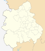
 خريطة لاقليم غرب ميدلاندز، يظهر فيها البلدات/المدن باللون الأحمر، طرق السيارات باللون الأزرق، م.طباللون الأخضر الفاتح والمنتزهات الطبيعية باللون الأخضر الداكن.
|
التاريخ

المجلس الاقليمي
الديموغرافيا
حمل المراهقين
الحرمان الاجتماعي
الانتخابات
. . . . . . . . . . . . . . . . . . . . . . . . . . . . . . . . . . . . . . . . . . . . . . . . . . . . . . . . . . . . . . . . . . . . . . . . . . . . . . . . . . . . . . . . . . . . . . . . . . . . . . . . . . . . . . . . . . . . . . . . . . . . . . . . . . . . . . . . . . . . . . . . . . . . . . . . . . . . . . . . . . . . . . . .
الأقاليم الاحصائية في الاتحاد الأوروپي
| من المستوى 1 | الرمز | من المستوى 2 | الرمز | من المستوى 3 | الرمز |
|---|---|---|---|---|---|
| غرب ميدلاندز | UKG | Herefordshire, Worcestershire and Warwickshire | UKG1 | Herefordshire | UKG11 |

|
Worcestershire CC | UKG12 | |||
| Warwickshire CC | UKG13 | ||||
| Shropshire and Staffordshire | UKG2 | Telford and Wrekin | UKG21 | ||
| Shropshire CC | UKG22 | ||||
| Stoke-on-Trent | UKG23 | ||||
| Staffordshire CC | UKG24 | ||||
| West Midlands | UKG3 | Birmingham | UKG31 | ||
| Solihull | UKG32 | ||||
| Coventry | UKG33 | ||||
| Dudley | UKG36 | ||||
| Sandwell | UKG37 | ||||
| Walsall | UKG38 | ||||
| Wolverhampton | UKG39 | ||||
الحكومة المحلية
يضم الاقليم رسمياً التقسيمات التالية:
| خريطة | Ceremonial county | Shire county / unitary | المقاطعات |
|---|---|---|---|
 |
1. Herefordshire U.A. | ||
| Shropshire | 2. Shropshire U.A. | ||
| 3. Telford and Wrekin U.A. | |||
| Staffordshire | 4. Staffordshire † | a) Cannock Chase, b) East Staffordshire, c) Lichfield, d) Newcastle-under-Lyme, e) South Staffordshire, f) Stafford, g) Staffordshire Moorlands, h) Tamworth | |
| 5. Stoke-on-Trent U.A. | |||
| 6. Warwickshire † | a) North Warwickshire, b) Nuneaton and Bedworth, c) Rugby, d) Stratford-on-Avon, e) Warwick | ||
| 7. West Midlands * | a) Birmingham, b) Coventry, c) Dudley, d) Sandwell, e) Solihull, f) Walsall, g) Wolverhampton | ||
| 8. Worcestershire † | a) Bromsgrove, b) Malvern Hills, c) Redditch, d) Worcester, e) Wychavon, f) Wyre Forest | ||
Key: †shire county | *مقاطعة كبرى
الديموغرافيا

| المقاطعة | السكان | الكثافة السكانية | أكبر سلطة محلية | أكبر مستوطنة |
|---|---|---|---|---|
| اقليم غرب ميدلاندز | 5,267,337 | 405/كم² | برمنگهام (1,006,500) | برمنگهام (1,006,500) |
| غرب ميدلاندز (مقاطعة) | 2,600,100 | 2,884/كم² | برمنگهام (1,006,500) | برمنگهام (1,006,500) |
| Staffordshire | 1,062,500 | 391/كم² | Stoke-on-Trent (240,636) | Stoke-on-Trent (259,252) |
| Worcestershire | 552,900 | 318/كم² | Wychavon (116,300) | Worcester (93,400) |
| Warwickshire | 522,200 | 264/كم² | وارويك (132,900) | Nuneaton (70,721) |
| Shropshire | 451,100 | 129/كم² | Shropshire (290,900) | تلفورد (138,241) |
| Herefordshire | 177,800 | 82/كم² | N/A[2] | Hereford (50,400) |
الاقتصاد


. . . . . . . . . . . . . . . . . . . . . . . . . . . . . . . . . . . . . . . . . . . . . . . . . . . . . . . . . . . . . . . . . . . . . . . . . . . . . . . . . . . . . . . . . . . . . . . . . . . . . . . . . . . . . . . . . . . . . . . . . . . . . . . . . . . . . . . . . . . . . . . . . . . . . . . . . . . . . . . . . . . . . . . .
التعليم
المدارس
الجامعات
| الجامعة | عدد الطلبة | الترتيب الوطني (1998–2007)[3] |
|---|---|---|
| جامعة وارويك | 21,598 | 7 |
| برمنگهام | 30,725 | 19 |
| جامعة أستون | 8,915 | 37 |
| جامعة كيل | 12,720 | 41 |
| جامعة كوڤنتري | 19,495 | 41 |
| جامعة ستافوردشاير | 15,200 | 82 |
| جامعة ووستر | 9,455 | 85 |
| جامعة مدينة برمنگهام | 25,010 | 96 |
| جامعة ولڤرهامپتون | 24,020 | 108 |
الاعلام الاقليمي
الرياضة
المصادر
- ^ Office for National Statistics - Key Statistics for Urban Areas Population data
- ^ County of Hereford forms single local government unit (Unitary Authority)
- ^ The Times (PDF). London http://extras.timesonline.co.uk/pdfs/univ07ten.pdf.
{{cite news}}: Missing or empty|title=(help)
وصلات خارجية
- Advantage West Midlands - Regional Development Agency
- Government Office for the West Midlands
- West Midlands Regional Assembly
- Government's list of councils in the West Midlands
- MLA West Midlands - Museums, Libraries and Archives Regional Agency
- NHS West Midlands - The regional Strategic Health Authority for the West Midlands
- West Midlands NO! - campaign against regional government in the West Midlands


