قفط
قفط | |
|---|---|
| الإحداثيات: 25°59′44″N 32°48′57″E / 25.99556°N 32.81583°E | |
| البلد | |
| Governorate | محافظة قنا |
| منطقة التوقيت | UTC+2 (EST) |
| • الصيف (التوقيت الصيفي) | +3 |
قفط هي مدينة صغيرة في محافظة قنا في مصر تقع على شاطئ النيل الشرقي تبعد عن الأقصر مسافة 43 كم.
. . . . . . . . . . . . . . . . . . . . . . . . . . . . . . . . . . . . . . . . . . . . . . . . . . . . . . . . . . . . . . . . . . . . . . . . . . . . . . . . . . . . . . . . . . . . . . . . . . . . . . . . . . . . . . . . . . . . . . . . . . . . . . . . . . . . . . . . . . . . . . . . . . . . . . . . . . . . . . . . . . . . . . . .
لمحة تاريخية
في مصر القديمة، قفط، التي كانت تُعرف آنذاك بإسم گبطو، كانت مركزاً هاماً للادارة والدين والتجارة، إذ كانت مركز of the fifth Upper Egyptian Nome of Harawî (Two Hawks). فمن قفط وقوص، trading expeditions heading for the Red Sea and many mining expeditions into the Eastern Desert left the وادي النيل. Gebtu was at the starting-point of the two great caravan routes leading to the coast of the البحر الأحمر, the one toward the port Tââou (Myoshormos), the other more southerly, toward the port of Shashirît (Berenice).
Under the native pharaohs, the whole trade of southern Egypt with the Red Sea passed over these two roads; under the Ptolemies as well as in Roman and Byzantine times, merchants followed the same roads for purposes of barter at the coasts of Zanzibar and in Southern Arabia, India, and the Far East.

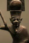
Gebtu was the most important religious center in the area. Its principal male deity was Min, a sky-god whose symbol was a thunderbolt. [1] He became a male fertility deity, [2], and also was regarded as the male deity of the desert region to the east.
His cult rose to prominence in the المملكة الوسطى. At that time, he became associated with Horus as the deity, Min-Horus. Later, he was fused with Amen in the deity Min-Amen-ka-Mut-ef, as "Min-Amen-bull of his mother" (حتحور-إيزيس).
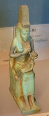
Isis (Hathor-Isis) and her infant, حورس, were the deities connected with Gebtu, named Coptos during the Greco-Roman period, probably due to the reinterpretation of the Two Hawks of the Nome, Harawî, standard as Min and Horus.
Gebtu, once politically important, especially under the الأسرة الحادية عشر, was overshadowed by Thebes. It recuperated its prominence under the Antonines; it was the base camp of الفيلق الثالث قورينا، أو على الأقل أحد وحداته. وقد تمردت في 292 حتى 295م، حين أرسـَل الامبراطور الروماني ديوكلتيان گالريوس، القيصر الروماني في البلقان، إلى مصر لمقاتلة المدينتين المتمردتين بوسيريس و قـُپطـُس. وقد سيطر گالريوس على قفط بعد حصار طويل ودمار معظمها، ثم سرعان عاودت الازدهار إلى سابق عهدها.
في القرن السادس، كانت قفط تُعرف باسمها الروماني، جستنيانوپوليس. ويُعتبر هذا القرن نهاية العصر الكلاسيكي في أوروپا حيث تلته العصور المظلمة.
The Christian see was suffragan of Ptolemais in Thebais Secunda. Five bishops are known (Lequien, II, 607): Theodorus, a partisan of Meletius; Phoebammon in 431; Sabinus in 451; Vincent, author of the "Canonical Solutions", preserved in an Arabic translation and highly esteemed by the Copts; Moyses, who wrote the panegyric of Vincent.
وفي عهد الخلفاء والسلاطين المسلمين، ظلت قفط واحدة من المدن الرئيسية في مصر العليا. وفي 1176، رفع سكانها المسيحيون راية العصيان على المسلمين، إلا أنهم سرعان ما أُخمـِدوا على يد الملك العادل، شقيق صلاح الدين، الذي شنق نحو 3,000 قبطي على الأشجار حول المدينة. وفي القرن 13 الميلادي، كانت هناك العديد من الأديرة حول المدينة. قفط تم تخريبها في القرن 16 على يد العثمانيين.
وكانت تعتبر قفط بوابه الطرق المودية إلى البحر الحمر ومدينة القصير وطريق الحج البري القديم.
ومن أشهر المعارك التي حدثت خلال الحملة الفرنسية على مصر معركة البارود وهي قرية في قفط كانت سبب في وقف الحملة الفرنسية على الصعيد. وكذلك معركة بئر عنبر التي كانت بقيادة ابراهيم باشا الذي استقر في الصعيد بعد الحملة مذبحة المماليك.
الآثار
عُثر على بقايا ثلاث مجموعات من المعابد ويحيط بها سور أثناء حفريات و. م. فلندرز پتري في 1893-1894، ولاحقاً، على يد ريموند وايل وأدولف يوسف رايناخ في 1910-1911.
المعبد الشمالي غير المزين للإلهتين مين وإيزيس was the work of an official named Sennuu on behalf of Roman occupiers during the Ptolemaic kingdom, namely, پطليموس الثاني فيلادلفوس الذي حكم من 281 ق.م. حتى 246 ق.م.
This northern temple has some later additions by پطليموس الرابع فيلوپاتور الذي حكم من 221-205 ق.م. He was the son of Ptolemy III and Berenice II of Egypt and was the fourth pharaoh of the Ptolemaic Egypt, when the decline of the Ptolemaic kingdom began. More additions were added by Julio-Claudian emperors of Rome, كاليگولا ونيرون.
This temple stands on the site of earlier Ancient Egyptian temple structures, those of the visor to منتوحوتپ الرابع الذي أصبح أمنمحات الأول وابنه، سنوسرت الأول، both of the الأسرة الثانية عشر، وتحتمس الثالث من الأسرة الثامنة عشر. بقايا مصلى اوزيريس، الذي أقامه أماسيس الثاني من الأسرة السادسة والعشرين، عثر عليها بالقرب من المعبد الشمالي.
At the site of the later middle temple built by Romans during the Ptolemaic kingdom, blocks of an earlier structure by سنوسرت الأول وبوابة تحتمس الثالث, with additions probably made by اوسوركون الثاني of the twenty-second dynasty, were found. This later middle temple was built during the Ptolemaic kingdom by Ptolemy II Philadelphus, with minor additions by members of the Julio-Claudian dynasty of Rome, كاليگولا, كلاوديوس, وتراجان.
At the site of the southern temple, are the gates of Nectanebo II of the thirtieth dynasty, who was the last native king of Egypt. He was placed on the throne by a Spartan king and lost a conflict with the Persians, who then overtook Egypt.
Other structures found at the site include a set of stelae, now known as the Koptos Decrees. These stelae date to the الأسرة السادسة and Seventh Dynasties, with copies of royal decrees from the pharaohs concerning the temple and its personnel. The name by which the stelae are known reflects the much later Greek name for the city, Coptos or Koptos however.
كما عُثر على مصلى لفرعونة الأسرة البطلمية كليوپاترا السابعة وابنها، پطليموس الخامس عشر قيصريون، في الموقع. These rulers of Ancient Egypt for six hundred years were not native, but of Greek origin. Without many changes, however, they adopted the culture and religious practices of the country they occupied. Cleopatra even learned the ancient Egyptian language, which never had been used by these rulers. The Greeks sought to find parallels to their own religious beliefs and would describe the Egyptian deities as related to their own.
Built even later, after the conquest by the Romans in 30 AD, gates associated with the Roman emperors كاليگولا وكلاوديوس are documented at the site. The Romans also continued the religious traditions of Ancient Egypt, adopting some completely, and drawing parallels (similar to the Greek rulers) for others.
وفي شمال شرق قفط، بالقرب من قرية القلعة، بنى كذلك الامبراطور الروماني كلاوديوس معبداً صغيراً وكرسه للإلهة مين، إيزيس وحورس.
وكانت قفط مركز بعثة استكشاف أثرية أمريكية من 1987 حتى 1992، وأخرى أسترالية بين 2000 و 2003.
بمدينة قفط تم اكتشاف معبد الاله مين اله الخصوبة عند القدماء والإلهة إيزيس.
التقسيم الاداري
قرى قفط عديدة تاتى في مقدمتهم
- قرية القلعة
- قرى الاشراف ،البراهمة، العروبة، البارود، بئر عنبر ونجع العكرمي, الكلاحين، الشيخية والعويضات.
- كوم المؤمنين من أشهرها نظرا لوجود الكثير من الحفريات الفرعونيه فيه حيث أنها تقع على تبة عالية عن سطح البحر لذا كان يلجا الناس اليه عند بدايه طوفان النيل.
وكان العرب يأتون بالموص وهو ملح الطعام وملح البارود من جبال البحر الاحمر وكان هذا الموص يستخدم في صناعة البارود.
أبناء قفط
ومن مشاهير مركز قفط
- أمل دنقل، ابن القلعة بلد الأمراء
- عبد الرحمن الأبنودي، الشاعر المبدع.
انظر أيضاً
وصلات خارجية
- Home Page, The Qift Regional Expedition, 31 July 2003, Archived from the original on 9 April 2005, http://web.archive.org/web/20050409021924/http://www.koptos.com/index.htm, retrieved on 28 June 2009
![]() هذه المقالة تضم نصاً من مطبوعة هي الآن مشاع: هربرمان, تشارلز, ed. (1913). الموسوعة الكاثوليكية. Robert Appleton Company.
هذه المقالة تضم نصاً من مطبوعة هي الآن مشاع: هربرمان, تشارلز, ed. (1913). الموسوعة الكاثوليكية. Robert Appleton Company. {{cite encyclopedia}}: Cite has empty unknown parameters: |1=, |coauthors=, and |month= (help); Invalid |ref=harv (help); Missing or empty |title= (help)
Coordinates: 25°59′44″N 32°48′57″E / 25.99556°N 32.81583°E
- Short description is different from Wikidata
- CS1 errors: missing title
- Articles incorporating text from the 1913 Catholic Encyclopedia with no article parameter
- Coordinates on Wikidata
- محافظة قنا
- أماكن مأهولة في محافظة قنا
- مراكز محافظة قنا
- مواقع يونانية قديمة في مصر
- مواقع رومانية في مصر
- معسكرات الفيالق الرومانية في مصر


