شعفاط


شعفاط (Šuʿafāṭ)، أيضاً Shu'fat and Sha'fat,[1] هو حي يغلب عليه العرب من القدس الشرقية ، ويشكل جزءًا من الشمال الشرقي للقدس.[2] تقع على طريق القدس القديمة - رام الله على بعد حوالي ثلاثة أميال شمال البلدة القديمة ، ويبلغ عدد سكان شعفاط 35000 نسمة.
بجانب حي شعفاط يوجد مخيم اللاجئين بنفس الاسم، والذي أنشأه الملك حسين ملك الأردن عام 1965 لإيواء اللاجئين الفلسطينيين من القدس، واللد ويافا والرملة بعد إغلاق معسكر المعسكر في الحي اليهودي بالبلدة القديمة.[3]
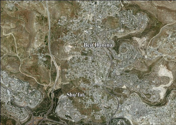
تحد شعفاط پسگات زئڤ وبيت حنينا من الشمال، ومخيم شعفاط من الشرق، والتلة الفرنسية من الجنوب، ورمات شلومو من الغرب.[4][5] تقع شعفاط في جزء من الضفة الغربية تم إدراجه ضمن الحدود البلدية للقدس بعد احتلالها عام 1967.
قامت على شعفاط ممالك عديدة، ومرت فيها السكة الحديدية العثمانية إلى الحجاز، وفيها آثار كثيرة. ويُقال أن الجن على زمن سيدنا سليمان عليه السلام تأخذ الحجارة التي بُني سور القدس منها. وقد وُجدت تحت الشارع الرئيسي فيها أنقاض مدينة قديمة ترجع للعهد الروماني كما وُجد فيها أيضا تابوت يُقال أنه للملكة كيلوباترا.
. . . . . . . . . . . . . . . . . . . . . . . . . . . . . . . . . . . . . . . . . . . . . . . . . . . . . . . . . . . . . . . . . . . . . . . . . . . . . . . . . . . . . . . . . . . . . . . . . . . . . . . . . . . . . . . . . . . . . . . . . . . . . . . . . . . . . . . . . . . . . . . . . . . . . . . . . . . . . . . . . . . . . . . .
أصل الكلمة
يُعتقد بأنها سميت بهذا الاسم نسبة إلى الملك الروماني شافاط (أو يوهشوفاط) المذكور في الإنجيل في عصر الرومان. وهناك من يذكر أنها هي ليست قرية، بل حي من أحياء القدس.
التاريخ

كانت شعفاط مأهولة بالسكان منذ زمن بعيد يرجع إلى 200 عام قبل الميلاد. سميت شعفاط بهذا الاسم نسبه إلى الملك الروماني شفاط الذي حكمها في عصر الرومان، ويعتقد أنها أقيمت على أنقاض قرية "تل الفول" الكنعانية، والتي تقع على مشارف القرية.
شارك سكانها في المقاومة ضد الاحتلال البريطاني لفلسطين في العشرينات من القرن العشرين.
تمت تسوية منطقة شعفاط بشكل متقطع، حيث يرجع تاريخ أقدم الاكتشافات المعمارية إلى العصر الحجري النحاسي قبل 7000 عام.[6] كشفت النتائج من القرن الثاني إلى القرن الأول قبل الميلاد عن وجود مستوطنة زراعية محصنة في تلك الفترة.[7][8][9] وصلت المستوطنة إلى أكبر حجم لها في العصر الروماني، بين 70-130م، قبل أن يتم التخلي عنها أو تدميرها بعد 135م ثورة بار كوخبا، ليتم إعادة توطينها على نطاق أصغر في القرنين الثاني والرابع.[10]
اقترح مؤرخو الكتاب المقدس في أواخر القرن التاسع عشر أنه قد يكون مرتبطًا بـ المصفاة في بنيامين،[11] و نوب،[12] بينما اقترحت إحدى المراجعات في القرن الحادي والعشرين Gebim، على الرغم من التحذير من أنه لا يزال غير مؤكد.[13]
القرن الثاني - الأول قبل الميلاد
بعد عملية الحفريات الأثرية التي أجراها ألكسندر أون وتسفي جرينهوت عام 1991 والتي اكتشفت مستوطنة زراعية محصنة من القرن الثاني قبل الميلاد بالقرب من شعفاط، يرجع تاريخ غرفة تحت الأرض في المجمع إلى أوائل القرن الأول قبل الميلاد، وتم تحديدها على أنها غرفة للصلاة أو كنيس يهودي. بعد ذلك، تم التشكيك بشدة في هذا التفسير للموقع.[7][8][9] في عام 2008 صرحت راشيل هاتشليلي أن المبنى لم يعد يعتبر كنيسًا يهوديًا.[14] تم التخلي عن المستوطنة بعد أن تضررت لأضرار بالغة جراء الزلزال الذي وقع عام 31 قبل الميلاد.[9]
كما تم اكتشاف مقابر يهودية تعود إلى هذه الفترة في رمات شلومو، في ما كان يُعرف سابقًا باسم شعفاط ريدج.[15] كما تم العثور في رمات شلومو على مقلع كبير، من المحتمل أن يكون مرتبطًا بـ بتوسع هيرودس للهيكل الثاني، يرجع تاريخه إلى تلك الفترة في رمات شلومو.[16]
الفترة الرومانية
تم اكتشاف بقايا مستوطنة يهودية من العصر الروماني، وذلك أثناء عملية تنقيب عن الآثار بالقرب من مخيم شعفاط للاجئين تمهيدًا لمد مسارات نظام القطار الخفيف في القدس.[17] كانت المستوطنة على الطريق الروماني الرئيسي المؤدي شمالاً من القدس باتجاه شكم/Flavia Neapolis.[18] كانت مأهولة بين ثورتين رئيسيتين لليهود ضد الرومان، حيث تأسست بعد تدمير القدس 70 م وتم التخلي عنها فجأة حوالي 130م، قبل وقت قصير من اندلاع ثورة بار كوخبا (132-36).[19][2]
يوصف بأنه مجتمع متطور تم التخطيط له بدقة من قبل السلطات الرومانية، مع وجود صفوف منظمة من المنازل وحمامين عامين رائعين إلى الشمال.[2] في وقت اكتشافها قيل إنها أول مؤشر على وجود مستوطنة يهودية نشطة في منطقة القدس بعد سقوط المدينة في 70 م.[20] وبمساحة إجمالية مفترضة تبلغ ج. 11 دونم (الحد الأدنى للطول 310 م، العرض 35 م)،[17] كما كانت تعتبر أكبر مستوطنة يهودية في ذلك الوقت "بالقرب من القدس".[21] المؤشر الرئيسي على أن المستوطنة كانت يهودية هو التجمع الكبير والمتنوع لأواني الحجر الطباشيري التي عثر عليها هناك.[20] مثل هذه الأواني، لتخزين الطعام وتقديمه، كان يستخدمها اليهود فقط لأنهم يُعتقد أنهم لا ينقلون النجاسة.[20] بعض الأواني المكتشفة هناك تنتمي إلى نوع تم العثور عليه فقط بعد 70 م.[19]
والدليل الأثري القاطع على الطابع اليهودي للمستوطنة هو وجود حمامات الطقوس اليهودية، والتي تم العثور على العديد منها خلال أعمال لاحقة.[20][2][10] إن وجود الحمامات العامة، والتأخير في العثور على حمامات الطقوس اليهودية، واكتشاف النبيذ الإيطالي واليوناني المستورد الذي ينتجه غير اليهود، والذي كان يتجنبه اليهود المهتمون بالنقاء في ذلك الوقت، جعل الباحثين يتكهنون في البداية فيما إذا ربما كانت المستوطنة مختلطة يهودية رومانية (وثنية)، مع الحمامات التي يديرها اليهود لصالح الجنود الرومان.[20][18] تشهد جودة المباني وغيرها من الاكتشافات، مثل الكنوز المعدنية الغنية، ومستحضرات التجميل، والأواني الحجرية والنبيذ المستورد، على ثروة السكان.[21][20]
أعيد توطين الموقع المهجور أو المدمر على نطاق أصغر في القرنين الثاني والرابع الميلادي، مع ظهور المدرجات الزراعية مؤخرًا غرب شارع شعفاط.[10]
الفترة الصليبية
كان المكان معروفًا للصليبيين باسم "Dersophath" أو "Dersophach".[22][23] في مارس 1179، لوحظ أن عائداتها ذهبت إلى دير القديسة ماري في جبل صهيون كنتيجة لمنحة قدمها أنسيلم دي بارينتي.[24]
تم العثور على بقايا هيكل صليبي في وسط القرية.[22] اعتقد گيران أنه من المحتمل أن تكون كنيسة: "أحد [المنزل] الذي لا يزال حتى اليوم يحمل اسم" الكنيسة "(الكنيسة)، يعرض بقايا مقدس مسيحي مواجه للشرق ونوافذها مدببة ويعود تاريخها في الغالب إلى العصور الوسطى. وقد تم استخدام بعض الأشلار الجميلة ذات المظهر العتيق، إلى جانب مواد أخرى أصغر، في بناء هذه الكنيسة الصغيرة".[25] ومع ذلك، لم يعثر شيك على أية كنيسة، "ببساطة مبنى صليبي قديم له نافذتان محفوظتان. يبلغ سمك الجدران حوالي 6 أقدام، والتي تم بناء منازل الفلاهين عليها، وبالتالي فإن الأمر ليس بالأمر السهل لنتعرف عليه. لقد كان نوعًا من خان مبني بالطريقة الصليبية المعتادة، مع | قبو أعلى قليلاً في المنتصف من نصف دائري."[26]
الفترة المملوكية
اكتشف علماء الآثار أن المصاطب الزراعية في المنطقة قد تم بناؤها وتغطيتها بالتربة السطحية خلال الفترة المملوكية (1260-1516).[10]
الفترة العثمانية
The village was incorporated into the Ottoman Empire in 1517 with all of Palestine, and in 1596 Shuafat appeared in Ottoman tax registers as being in the Nahiya of Quds of the Liwa of Quds. It had eight Muslim families who paid taxes on wheat, barley, vineyards and other agricultural produce; a total of 2,200 akçe.[27]
In 1838, Edward Robinson described Shuafat as a small Muslim village with the remains of an old wall,[28][29] while de Saulcy, who saw it in 1851, wrote that "this village has the appearance of a castle of the middle ages with a square keep."[30]
The French explorer Guérin visited in 1863 and noted that the village was situated on an elevated plateau "from which one can make out perfectly the cupolas and minarets of Jerusalem," and that it counted 150 inhabitants. He described the houses as for the most part fairly old and vaulted internally.[31] He noted the remains of a church called al-Kanisa, facing east. He thought it was a Frankish church.[32] He also passed by in 1870.[33] An official Ottoman village list from about 1870 showed 23 houses and a population of 90, counting men only.[34][35]
In 1883, the Palestine Exploration Fund's Survey of Western Palestine described Shuafat as "A small village, standing on a flat spur immediately west of the watershed, surrounded with olive-trees. It has wells to the north. There is a sacred chapel of Sultan Ibrahim in the village."[11] In 1896 the population of Scha'fat was estimated to be about 276 persons.[36]
The Ottomans built a road in the same place as the old Roman road linking Jerusalem to Nablus.[18]
. . . . . . . . . . . . . . . . . . . . . . . . . . . . . . . . . . . . . . . . . . . . . . . . . . . . . . . . . . . . . . . . . . . . . . . . . . . . . . . . . . . . . . . . . . . . . . . . . . . . . . . . . . . . . . . . . . . . . . . . . . . . . . . . . . . . . . . . . . . . . . . . . . . . . . . . . . . . . . . . . . . . . . . .
فترة الانتداب البريطاني
In the 1922 census of Palestine conducted by the British Mandate authorities, Sha'afat had a population 422, all Muslims,[37] increasing in the 1931 census to 539, still all Muslims, in 123 houses.[38]
In the 1945 statistics the population of Shu'fat was 760, all Muslims,[39] and it had 5,215 dunams of land according to an official land and population survey.[40] 484 dunams were for plantations and irrigable land, 2,111 for cereals,[41] while 62 dunams were built-up (urban) land.[42]
الفترة الأردنية
The town of Shuafat was to be the most northernmost point of the corpus separatum proposed in 1947 for Jerusalem and its surrounding villages, which "in view of its association with three world religions" was to be "accorded special and separate treatment from the rest of Palestine and should be placed under effective United Nations control".[43]
In mid-February, during the 1948 Arab–Israeli War, Abd al-Qadir al-Husayni, leader of Palestinian irregulars in the area, tried to persuade the residents of Shuafat to attack the neighbouring Jewish village of Neve Yaakov but the invitation was declined.[44][45] On 13 May the villagers were evacuated on orders from the Arab Legion. Shortly afterwards the Palmach captured Shuafat, destroying many of the buildings.[46] Shuafat was then occupied by Jordan, which annexed the West Bank in April 1950.[47]
Jordan's king Hussein also built a palace here.[48]
In 1961, the population of Shuafat was 2,541,[49] of whom 253 were Christian.[50]
مخيم شعفاط

In the wake of the 1948 war, the Red Cross accommodated Palestinian refugees in the depopulated and partly destroyed Jewish Quarter of Jerusalem's Old City.[51] This grew into the Muaska refugee camp managed by UNRWA, which housed refugees from 48 locations now in Israel.[52] Over time many poor non-refugees also settled in the camp.[52] Conditions became unsafe for habitation due to lack of maintenance and sanitation, but neither UNRWA nor the Jordanian government wanted the negative international response that would result if they demolished the old Jewish houses.[52]
In 1964, a decision was made to move the refugees to a new camp constructed on mostly Jewish land near Shuafat.[52] Most of the refugees refused to move, since it would mean losing their livelihood, the market and the tourists, as well as reducing their access to the holy sites.[52] In the end, many of the refugees were moved to Shuafat by force during 1965 and 1966.[51][52]
1967 وما بعده
After the Six-Day War in 1967, East Jerusalem, including the town and refugee camp, was occupied and later annexed by Israel and were incorporated into the Jerusalem municipal district.[2][53] The residents were offered Israeli citizenship, but most refused it as they considered the area to be illegally occupied. Many accepted permanent residency status instead.[2]
According to ARIJ, Israel has illegally and unilaterally redrawn the boundaries of Jerusalem Municipality, and confiscated 3,989 dunams of Shu’fat land (47% of the total town's area) in order to establish five Israeli settlements:[54]
- 1,494 dunams for Rekhes Shufat (Ramat Shlomo)[55]
- 1,446 dunams for Ramot (Ramot Allon)[55]
- 416 dunams for Ramat Eshkol[55]
- 239 dunams for Pisgat Amir[55]
- 394 dunams for Giva't Shappira (French Hill)[55]
The Shuafat refugee camp is the only Palestinian refugee camp located inside Jerusalem or any other Israeli-administered area. While its residents carry Jerusalem identity cards, which grants them the same privileges and rights as regular Israelis, the camp itself is largely serviced by the United Nations Relief and Works Agency, even though 40 - 50% of the camp's population are not registered refugees. The Israeli West Bank barrier was partially constructed between the camp and the rest of Shuafat and Jerusalem. Some health services are provided by Israeli clinics in the camp. The Israeli presence is limited to checkpoints controlling entry and exit. According to Ir Amim, the camp suffers from high crime as Israeli Police rarely enter due to security concerns and the Palestinian Civil Police Force do not operate in Israeli-administered municipalities. Unlike other UN-run refugee camps, residents of Shuafat camp pay taxes to the Israeli authorities.[4][56]
The Shuafat Ridge next to the township was declared a 'green zone' to stop Palestinians in Shuafat from building there, until the opportunity arose to unfreeze its status as a green area and open it up for a new Jewish neighbourhood, as Teddy Kollek openly admitted.[57]
In a survey conducted as part of the research for the book Negotiating Jerusalem (2000), it was reported that 59% of Israeli Jews supported redefining the borders of the city of Jerusalem so as to exclude Arab settlements such as Shuafat, in order to ensure a "Jewish majority" in Jerusalem.[58]
In July 2001, the Israeli authorities destroyed 14 homes under construction in Shuafat on the orders of then mayor Ehud Olmert, who said the structures were built without permits. No one was yet living in them.[59] The families acknowledged they do not own the land they built on, but believed they had permission to build there from Islamic Trust religious authorities and argue that obtaining permits to build legally is nearly impossible. Olmert said the houses were being constructed on public land in a "green area" and posed a security threat to the Jews of Pisgat Zeev.[60] According to Isabel Kershner of the New York Times, Shuafat suffered from an absence of municipal planning, overcrowding, and potholed roads in 2007.[2]
As prime minister, Ehud Olmert questioned whether the annexation of areas like Shuafat into the Jerusalem area was necessary.[61] The Israeli initiative to transfer control of the area to the Palestinian National Authority led to a split in the community: A camp official favored being under Palestinian sovereignty, while the neighborhood's mukhtar rejected the plan, citing his residents' participation in Israeli elections as well as the danger of Palestinian rocket attacks on Israel.[62]
In 2012, Sorbonne scholar Prof. Sylvaine Bulle cited the Shuafat refugee camp for its urban renewal dynamic, seeing it as an example of a creative adaptation to the fragmented space of the camps towards creating a bricolage city, with businesses relocating from east Jerusalem there and new investment in commercial projects.[63]
Three stations of the First 'Red' Line of the Jerusalem Light Rail are situated in Shuafat: Shuafat North, Shuafat Central and Shuafat South.[64][65]
The neighbourhood's Main Street, Shuafat Road, was previously part of route 60. In the 1990s a new route was built to the east of the neighbourhood, a dual carriageway with 3 lines in each direction, relieving traffic congestion along the road.
In 2014, the 16-year-old Mohammed Abu Khdeir was kidnapped from near his home in Shuafat. He was then murdered by his kidnappers, who were Jewish extremists.
مخيم شعفاط

يقع إلى الشّرق من شعفاط مخيم شعفاط الذي أسس عام 1965.
الجغرافيا
تقع قرية شعفاط على مسافة 5 كيلومترات إلى الشّمال من البلدة القديمة في القدس، وتقع ضمن حدود نفوذ بلدية الاحتلال الإسرائيلي في القدس. تحدّ القرية من الشّرق عناتا وحزما، ومن الشّمال بيت حنينا، ومن الغرب بيت اكسا، ومن الجنوب العيسوية. ومساحتها حوالي 4277 دونم[66] قامت سلطات الاحتلال الإسرائيلي بمصادرة ما يقارب 47% من أراضي شعفاط لصالح بناء المستوطنات والقواعد العسكرية وجدار الفصل العنصري . ويحيط بالقرية خمس خرب، هي: خربة الصومعة، خربة الرأس، خربة المصانع، خربة تل الفول، خربة العدسة، وتحتوي هذه الخرب على العديد من المواقع الأثرية.[67]
. . . . . . . . . . . . . . . . . . . . . . . . . . . . . . . . . . . . . . . . . . . . . . . . . . . . . . . . . . . . . . . . . . . . . . . . . . . . . . . . . . . . . . . . . . . . . . . . . . . . . . . . . . . . . . . . . . . . . . . . . . . . . . . . . . . . . . . . . . . . . . . . . . . . . . . . . . . . . . . . . . . . . . . .
الديموغرافيا
يزيد عدد السكان عن 32 ألف نسمة حتى عام 2012م، وتعتبر شعفاط، مثل قرية بيت حنينا، مركزاً تجارياً نشطاً يجذب العديد من سكان البلدة والقرى المجاورة شمالي القدس، ففي شعفاط عدد من المراكز التّجاريّة، والمرافق التّعليمية والصّحيّة، والترفيهيّة التي تخدم الكثيرين.
مضايقات الاحتلال

جدار الفصل العنصري
بعد إقامة حاجز شعفاط تم فصل القرية عن مخيم شعفاط وعن قرية عناتا. كما أن بناء جدار الضمّ والتوسع وعدد من المستوطنات القريبة أدى إلى عزل شعفاط ووضع العراقيل أمام أي نمو عمراني، مما يعني عدم القدرة على الاستجابة لحاجات السّكان المتزايدة للإسكان.
التوسع الاستيطاني ومصادرة الأراضي
تحيط القرية مستوطنات بسجات زئيف، التلة الفرنسية، رامات اشكول، ورامات شلومو. نتيجة لموقعها الاستراتيجي باعتبارها الضّاحية الشّمالية لمدينة القدس المحتلة، تعرضت شعفاط لمصادرة الأراضي كجزء من عملية التهويد المتصاعدة في المدينة وفي 2013 قامت جرافات البلدية بتجريف الاراضي الزراعية و خلغ أشجار الزيتون بهدف فتح شارع رقم 21 و الذي يربط مدينة القدس بالمستوطنات الموجوده منها راموت شلومو وراموت وغيرها. وفي2011 تم تفعيل القطار الذي يمر من أراضي شعفاط والذي يخدم المستوطنات المجاورة بيسغات زئيف والتله الفرنسيه.
هدم البيوت
تعد قضية الحصول على تراخيص لبناء البيوت واحدة من أكبر الصعوبات التي تواجه سكان شعفاط. يعود ذلك لسببيين أساسيين: التكلفة المادية المرتفعة للأراضي، والتكلفة المادية المرتفعة المرتبطة بالحصول على رخصة للبناء. وبما أن شعفاط موقع استراتيجي لعمليات التهويد والاستيطان، نظراً لقربها من البلدة القديمة، فإنّ بلدية الاحتلال تتشدد في منح رخص البناء لأهاليها. أشارت مؤسسة المقدسي في تقرير لها إلى توثيقها 3 حالات هدم لمنشآت في شعفاط، 2 منها سكنية، وقد أدى هدمها إلى تشريد 7 فلسطينيين حتى عام 2014.[68]
تضييق المساحة
تفتقر شعفاط للمساحات الواسعة المفتوحة، وإلى الأراضي المناسبة للبناء العمراني، مع نسبة كثافة سكانية عالية، وسرقة الاراضي من قبل الاحتلال.
مرئيات
| اشتباكات بمخيم شعفاط وإصابات بمواجهات مع الاحتلال بعناتا
في أكتوبر 2022 |
انظر أيضاً
المصادر
- ^ de Saulcy, 1854, p. 116
- ^ أ ب ت ث ج ح خ Isabel Kershner (June 5, 2007). "Under a Divided City, Evidence of a Once United One". The New York Times. Retrieved 2018-07-28.
- ^ UNWRA. "Shu'fat refugee camp". Retrieved 2014-08-24.
- ^ أ ب "New checkpoint opened at entrance to Shuafat". The Jerusalem Post. December 2011. Retrieved 2012-02-20.
- ^ "Jerusalem Neighborhood Profile: Shuafat Refugee Camp". Ir Amim. August 2006. Archived from the original (DOC) on 2011-08-22. Retrieved 2008-02-01.
- ^ Haaretz, Jerusalem Even Older Than Thought: Archaeologists Find 7,000-year-old Houses, 17 February 2016 [1]
- ^ أ ب Rainer Reisner, 'Synagogues in Jerusalem,' in Richard Bauckham The Book of Acts in its First Century Setting, Wm. B. Eerdmans Publishing, 1995 pp.179–212 p.192
- ^ أ ب Lee I. Levine (2005). The Ancient Synagogue (2nd. ed.). Yale University Press. p. 72.
The case for a synagogue or prayer hall at this site appears to have evaporated.
- ^ أ ب ت Anders Runesson; Donald D. Binder; Birger Olsson (2008). The ancient synagogue from its origins to 200 A.D. Leiden: Brill. pp. 75–76. ISBN 978-9004161160.
Unless further excavations or more detailed information can strengthen the case for the identification of this building as a synagogue, the authors believe the claim should be withdrawn.
- ^ أ ب ت ث Yeger, David (22 January 2017). "Jerusalem, Shuʽfat (A): Final Report". Hadashot Arkheologiyot – Excavations and Surveys in Israel (HA-ESI). Jerusalem: Israel Antiquities Authority (IAA). 129. Retrieved 28 July 2018.
- ^ أ ب Conder and Kitchener, 1883, SWP III, pp. 13–14
- ^ Geikie, 1887, pp. 158–159.
- ^ Eerdmans Dictionary of the Bible. Wm. B. Eerdmans. 2000. p. 487. ISBN 0-8028-2400-5.
shuafat.
- ^ Rachel Hachlili, Ancient Synagogues - Archaeology and Art: New Discoveries and Current Research,, BRILL, 2013 p.39.
- ^ Rachel Hachlili (2005). Jewish Funerary Customs, Practices And Rites In The Second Temple Period. ISBN 9789004123731.
A Second Temple Period Tomb on the Shuafat Ridge, North Jerusalem
- ^ ROSENFELD, Amnon, et al. "BUILDING STONES FROM A QUARRY IN NORTHERN JERUSALEM PROBABLY USED IN THE TEMPLE MOUNT: 5 YEARS AFTER THE DISCOVERY." 2014 GSA Annual Meeting in Vancouver, British Columbia. 2014.
- ^ أ ب Sklar-Parnes, Deborah A. (8 May 2005). "Jerusalem, Shu'fat: Ramallah Road". Hadashot Arkheologiyot – Excavations and Surveys in Israel (HA-ESI). Jerusalem: Israel Antiquities Authority (IAA). 117. Retrieved 28 July 2018.
- ^ أ ب ت "Post-Roman [sic] Ancient Jewish Village Discovered: Finding calls into doubt belief that all Jews fled Holy Land after Roman destruction". 4 January 2006. Retrieved 28 July 2018.
- ^ أ ب Adler, Yonatan
- ^ أ ب ت ث ج ح Amiram Barkat (2006-01-02). "Shuafat dig reveals first sign of Jewish life after destruction of Second Temple". Haaretz. Retrieved 2018-07-28., Haaretz
- ^ أ ب Israel Antiquities Authority (10 April 2007). "Remains of Jewish settlement revealed in the Shu'afat neighborhood of Jerusalem". Israel Ministry of Foreign Affairs website. Retrieved 28 July 2018.
- ^ أ ب Pringle, 1997, p. 94
- ^ Pringle, 1998, #235, pp. 316–317
- ^ Röhricht, 1893, RRH, pp. 153–154, No 576
- ^ Guérin, 1868, p. 395
- ^ Schick, 1891, p. 200
- ^ Hütteroth and Abdulfattah, 1977, p. 120
- ^ Robinson and Smith, 1841, vol 2, p. 318, vol 3, p. 75
- ^ Robinson and Smith, 1841, vol 3, Appendix 2, p. 121
- ^ de Saulcy, 1854, pp. 114–116
- ^ Guérin, 1868, pp. 395–402
- ^ Ellenblum, 2003, p. 241
- ^ Guérin, 1874, p. 185
- ^ Socin, 1879, p. 160
- ^ Hartmann, 1883, p. 127 noted 26 houses
- ^ Schick, 1896, p. 121
- ^ Barron, 1923, Table VII, Sub-district of Jerusalem, p. 14
- ^ Mills, 1932, p. 43
- ^ Government of Palestine, Department of Statistics, 1945, p. 25
- ^ Government of Palestine, Department of Statistics. Village Statistics, April, 1945. Quoted in Hadawi, 1970, p. 58
- ^ Government of Palestine, Department of Statistics. Village Statistics, April, 1945. Quoted in Hadawi, 1970, p. 104
- ^ Government of Palestine, Department of Statistics. Village Statistics, April, 1945. Quoted in Hadawi, 1970, p. 154
- ^ Paul Jacob Ignatius Maria de Waart (1994). Dynamics of Self-Determination in Palestine: Protection of Peoples As a. BRILL. p. 216. ISBN 90-04-08286-7.
- ^ Morris, 1987, p. 38
- ^ "American Newlyweds in Israel, 1948". American Jewish Historical Society. 11 April 2011. Retrieved 25 April 2011.
- ^ Morris, 1987, pp. 67, 113, 158
- ^ Eyāl Benveniśtî. The international law of occupation, Princeton University Press, 2004. pg. 108. ISBN 0-691-12130-3.
- ^ Mariam Shahin (2005). Palestine: A Guide. Interlink Books. p. 334. ISBN 1-56656-557-X.
- ^ Government of Jordan, Department of Statistics, 1964, p. 14
- ^ Government of Jordan, Department of Statistics, 1964, pp. 115-116
- ^ أ ب Meron Benvenisti (1976). Jerusalem: The Torn City. Isratypeset. p. 70.
- ^ أ ب ت ث ج ح Avi Plascov (1981). The Palestinian Refugees in Jordan 1948–1957. Frank Cass.
- ^ Noah Browning, 'In bleak Arab hinterland, hints of Jerusalem's partition,' Reuters December 20, 2013.
- ^ Shu’fat Town Profile, ARIJ, 2013 p. 13
- ^ أ ب ت ث ج Shu’fat Town Profile, ARIJ, 2013 p. 14
- ^ "Jerusalem Neighborhood Profile: Shuafat Refugee Camp". Ir Amim. August 2006. Archived from the original (DOC) on 2011-08-22. Retrieved 2008-02-01.
- ^ Eyal Weizman, Hollow Land: Israel's Architecture of Occupation, Verso Books 2012 p.50
- ^ Jerome M. Segal (2000). Negotiating Jerusalem. SUNY Press. p. 127. ISBN 0-7914-4537-2.
- ^ Violence flares in Jerusalem as Israeli bulldozers destroy dozen 'illegal' homes[dead link], The Independent
- ^ Tracy Wilkinson (July 10, 2001). "Israel Razes 14 Arab Homes at Refugee Camp". Los Angeles Times. p. in print edition A-4. Retrieved 2008-09-07.
- ^ Meranda, Amnon (October 15, 2007). "Olmert hints at possible concessions in Jerusalem". Ynetnews. Ynet. Retrieved 2008-02-01.
- ^ "Shuafat area residents split over plan to divide Jerusalem in two". The Jerusalem Post. October 2007. Retrieved 2012-02-20.
- ^ Esther Zandberg (2008-10-23). "Their Shoafat outshines her Paris". Haaretz. Retrieved 2012-12-04.
- ^ Stations Archived 2011-07-21 at the Wayback Machine
- ^ "The Jerusalem Light Rail Map", Citypass, http://www.citypass.co.il/english/FirstLine3bigmappE.htm, retrieved on 2009-11-08
- ^ "مشاكل الملكية والتخطيط في القدس"، خليل التفكجي، مركز الأبحاث، منظمة التحرير الفلسطينية، 2013، ص.31
- ^ احياء وقرى القدسة - شعفاط Archived 2016-04-24 at the Wayback Machine
- ^ ملف شعفاط في معهد الأبحاث التطبيقية – أريج، تم الوصول إليه في أيار 2014
المراجع
- Bauckham, Richard (1995). The Book of Acts in Its Palestinian Setting. Grand Rapids, Michigan: Wm. B. Eerdmans Publishing. ISBN 0-85364-566-3.
- Barron, J. B., ed. (1923). Palestine: Report and General Abstracts of the Census of 1922. Government of Palestine.
- Conder, Claude Reignier; Kitchener, H. H. (1883). The Survey of Western Palestine: Memoirs of the Topography, Orography, Hydrography, and Archaeology. Vol. 3. London: Committee of the Palestine Exploration Fund.
- Ellenblum, Ronnie (2003). Frankish Rural Settlement in the Latin Kingdom of Jerusalem. Cambridge University Press. ISBN 9780521521871.
- Geikie, C. (1887). The Holy Land and the Bible. Vol. 2. London: Cassell.
- Government of Jordan, Department of Statistics (1964). First Census of Population and Housing. Volume I: Final Tables; General Characteristics of the Population (PDF).
- Government of Palestine, Department of Statistics (1945). Village Statistics, April, 1945.
- Guérin, Victor (1868). Description Géographique Historique et Archéologique de la Palestine (in French). Vol. 1: Judee, pt. 1. Paris: L'Imprimerie Nationale.
{{cite book}}: CS1 maint: unrecognized language (link) - Guérin, Victor (1874). Description Géographique Historique et Archéologique de la Palestine (in French). Vol. 2: Samarie, pt. 1. Paris: L'Imprimerie Nationale.
{{cite book}}: CS1 maint: unrecognized language (link) - Hadawi, Sami (1970). Village Statistics of 1945: A Classification of Land and Area ownership in Palestine. Palestine Liberation Organization Research Center.
- Hartmann, M. (1883). "Die Ortschaftenliste des Liwa Jerusalem in dem türkischen Staatskalender für Syrien auf das Jahr 1288 der Flucht (1871)". Zeitschrift des Deutschen Palästina-Vereins. 6: 102–149.
- Hütteroth, Wolf-Dieter; Abdulfattah, Kamal (1977). Historical Geography of Palestine, Transjordan and Southern Syria in the Late 16th Century. Erlanger Geographische Arbeiten, Sonderband 5. Erlangen, Germany: Vorstand der Fränkischen Geographischen Gesellschaft. ISBN 3-920405-41-2.
- Mills, E., ed. (1932). Census of Palestine 1931. Population of Villages, Towns and Administrative Areas. Jerusalem: Government of Palestine.
- Morris, Benny (1987). The Birth of the Palestinian refugee problem, 1947-1949. Cambridge University Press. ISBN 0-521-33028-9.
- Morris, Benny (2004). The Birth of the Palestinian Refugee Problem Revisited. Cambridge University Press. ISBN 978-0-521-00967-6.
- Palmer, E. H. (1881). The Survey of Western Palestine: Arabic and English Name Lists Collected During the Survey by Lieutenants Conder and Kitchener, R. E. Transliterated and Explained by E.H. Palmer. Committee of the Palestine Exploration Fund.
- Pringle, Denys (1997). Secular buildings in the Crusader Kingdom of Jerusalem: an archaeological Gazetter. Cambridge University Press. ISBN 0521 46010 7.
- Pringle, Denys (1998). The Churches of the Crusader Kingdom of Jerusalem: Volume II L-Z (excluding Tyre). Cambridge University Press. ISBN 0 521 39037 0.
- Robinson, Edward; Smith, Eli (1841). Biblical Researches in Palestine, Mount Sinai and Arabia Petraea: A Journal of Travels in the year 1838. Vol. 2. Boston: Crocker & Brewster.
- Robinson, Edward; Smith, Eli (1841). Biblical Researches in Palestine, Mount Sinai and Arabia Petraea: A Journal of Travels in the year 1838. Vol. 3. Boston: Crocker & Brewster.
- Röhricht, Reinhold (1893). (RRH) Regesta regni Hierosolymitani (MXCVII-MCCXCI) (in Latin). Berlin: Libraria Academica Wageriana.
{{cite book}}: CS1 maint: unrecognized language (link) - Saulcy, Louis Félicien de (1854). Narrative of a journey round the Dead Sea, and in the Bible lands, in 1850 and 1851. Vol. 1, new edition. London: R. Bentley.
- Schick, C. (1891). "Reports from Jerusalem - Letters from Herr Schick". Quarterly statement - Palestine Exploration Fund. 23: 198–204. doi:10.1179/peq.1891.23.3.198.
- Schick, C. (1896). "Zur Einwohnerzahl des Bezirks Jerusalem". Zeitschrift des Deutschen Palästina-Vereins. 19: 120–127.
- Socin, A. (1879). "Alphabetisches Verzeichniss von Ortschaften des Paschalik Jerusalem". Zeitschrift des Deutschen Palästina-Vereins. 2: 135–163.
- Tobler, Titus. (1854). Dr. Titus Toblers zwei Bucher Topographie von Jerusalem und seinen Umgebungen (in German). Vol. 2. Berlin: G. Reimer.
{{cite book}}: CS1 maint: unrecognized language (link) (pp. 899- 890)
وصلات خارجية
- Welcome To Shu'fat
- Shu'fat Town (Fact Sheet), Applied Research Institute–Jerusalem, ARIJ
- Shu’fat Town Profile, ARIJ
- Shu’fat aerial photo, ARIJ
- Survey of Western Palestine, Map 17: IAA, Wikimedia commons

مواقع وسكان مخيمات اللاجئين الفلسطينيين اعتباراً من 2015[1] | ||||||||||||||||||||||||||||||||||||||||||||||||||||||||||||||||||||||||||||||||||||
|---|---|---|---|---|---|---|---|---|---|---|---|---|---|---|---|---|---|---|---|---|---|---|---|---|---|---|---|---|---|---|---|---|---|---|---|---|---|---|---|---|---|---|---|---|---|---|---|---|---|---|---|---|---|---|---|---|---|---|---|---|---|---|---|---|---|---|---|---|---|---|---|---|---|---|---|---|---|---|---|---|---|---|---|---|
| ||||||||||||||||||||||||||||||||||||||||||||||||||||||||||||||||||||||||||||||||||||
المصادر
| ||||||||||||||||||||||||||||||||||||||||||||||||||||||||||||||||||||||||||||||||||||

Coordinates: 31°48′55.00″N 35°13′48.00″E / 31.8152778°N 35.2300000°E