بانجول
بانجول
ߓߊ߲߬ߖߎߟ Banjul 𞤄𞤢𞤲𞥆𞤶𞤵𞤤𞤵 Bannjulu | |
|---|---|
 مسجد الملك فهد في بانجول | |
 Flag  Coat of arms | |
 بانجول موقع بانجول في گامبيا  بانجول بانجول (أفريقيا) | |
| الإحداثيات: 13°27′11″N 16°34′39″W / 13.45306°N 16.57750°WCoordinates: 13°27′11″N 16°34′39″W / 13.45306°N 16.57750°W | |
| البلد | گامبيا |
| القسم | بانجول |
| تأسست | 23 أبريل 1816 بإسم باثهرست Bathurst |
| الحكومة | |
| • العمدة | روحي مالك لو |
| المساحة | |
| • المدينة | 12 كم² (5 ميل²) |
| • الحضر | 93 كم² (36 ميل²) |
| المنسوب | 0 m (0 ft) |
| التعداد (2013 census) | |
| • المدينة | 31٬301 |
| • الكثافة | 2٬600/km2 (6٬800/sq mi) |
| • Urban | 413٬397 |
| • الكثافة الحضرية | 4٬400/km2 (12٬000/sq mi) |
| منطقة التوقيت | UTC±00:00 (GMT) |
| HDI (2017) | 0.552[1] medium |
| الموقع الإلكتروني | www |
بانجول بالإنجليزية Banjul ، العاصمة، وأكبر مدينة في جامبيا، يبلغ عدد سكانها 44,188 نسمة. تقع على مصب نهر جامبيا على جزيرة سانت ماري الواقعة على طول الساحل الغربي من إفريقيا.هُناك جسر يربط بانجول بالبر الرئيسي. بانجول هي الميناء الرئيسي لجامبيا، ويُعَدّ الفول السُوداني من الصادرات الرئيسية للميناء. كما تتركز معظم الصناعات الجامبية في منطقة بانجول، وتوجد في المنطقة مصانع لمعالجة الفول السوداني وإنتاج المشروبات والأقمشة وتجميع الآلات الزراعية.
The population of the city proper is 31,301, with the Greater Banjul Area, which includes the City of Banjul and the Kanifing Municipal Council, at a population of 413,397 (2013 census).[2] The island is connected to the mainland to the west and the rest of Greater Banjul Area via bridges. There are also ferries linking Banjul to the mainland at the other side of the river.
From the 19th century until 24 April 1973, the city was known as Bathurst.[3]

. . . . . . . . . . . . . . . . . . . . . . . . . . . . . . . . . . . . . . . . . . . . . . . . . . . . . . . . . . . . . . . . . . . . . . . . . . . . . . . . . . . . . . . . . . . . . . . . . . . . . . . . . . . . . . . . . . . . . . . . . . . . . . . . . . . . . . . . . . . . . . . . . . . . . . . . . . . . . . . . . . . . . . . .
أصل الاسم
There are several etymologies for 'Banjul.' One traditional history recounts that Bandjougou, son of Barafin, came to the island after fleeing the attacks of Soumaoro Kante on the Manding region. His name became attached to the island, and over time changed to 'Bandjoulou'.[4] Another theory claims that Banjul takes its name from Bang julo, the Mandinka word for rope fibre that the Mandinka people gathered on the island.[بحاجة لمصدر]
تاريخ


In 1651, Banjul was leased by the Duke of Courland and Semigallia (German: Herzog von Kurland und Semgallen) from the King of Kombo, as part of the Couronian colonization.[5]
أنشأ البريطانيون المدينة سنة 1816 وسمُّوها باثهيرست. واتُّخذت المدينة في بادئ الأمر بمثابة قاعدة ينطلق منها البريطانيون لإيقاف تجارة الرقيق في إفريقيا، وسرعان ما أصبحت المدينة مركزًا تجاريًا، وأدار البريطانيون المدينة باعتبارها جزءًا من المستعمرة التي أسَّسُوها في جامبيا إلى أن حصلت البلاد على استقلالها في سنة 1965، ثم سُمِّيَت المدينة من جديد باسم بانجول في 1973.
On 23 April 1816, Tumani Bojang, the King of Kombo, ceded Banjul Island to Alexander Grant, the British commandant, in exchange for an annual fee of 103 iron bars. Grant's expedition, consisting of 75 men and tasked with establishing a military garrison, had been ordered by Charles MacCarthy.[6] Grant founded Banjul as a trading post and base, constructing houses and barracks for controlling entrance to the Gambia estuary and suppressing the slave trade.[7] The British renamed Banjul Island as St. Mary's Island and named the new town Bathurst, after the 3rd Earl Bathurst, Secretary of State for War and the Colonies at the time.[8] Streets were laid out in a modified grid pattern, and named after Allied generals at the Battle of Waterloo. The town became the centre of British activity in the Gambia Colony and Protectorate.[8]
Within a few years of its establishment the town started attracting migrants. Its population consisted of Africans of various origins, Levantines (Syrians, Lebanese) as well as Europeans (English, French, Portuguese). A majority of the population was Muslim but there was a significant Christian minority, including the Aku inhabitants. The majority of the Africans consisted of Wolof people, whose population rose from 829 in 1881 to 3,666 in 1901 and then 10,130 in 1944. They had mainly hailed from Gorée and Saint-Louis. The Mandinka were the second largest African group, followed by the Jola as well as the Fula. Islamic schools called dara were founded in Bathurst from its early years, resulting in the foundation of the first Muslim court in 1905, in addition to the increasingly more sophisticated British legal framework.[6]
Bathurst was officially declared the capital of the Protectorate of the Gambia in 1889, leading to an increase in population. Through the 20th century, it became an even greater attraction for Gambians due to the availability of jobs fuelled by British colonial activities as well as social activities such as cinemas. Young men from rural farming villages would move to Bathurst to work at the Public Works Department (established in 1922) or docks. The town was an important Allied naval and air hub during World War II, resulting in an increase in population from 14,370 in 1931 to 21,154 in 1944.[6]
After independence, the town's name was changed to Banjul in 1973.[7] On 22 July 1994, Banjul was the scene of a bloodless military coup d'état in which President Sir Dawda Jawara was overthrown and replaced by Yahya Jammeh. To commemorate this event, Arch 22 was built as an entrance portal to the capital. The gate is 35 metres tall and stands at the centre of an open square. It houses a textile museum.
الجغرافيا
تقع بانجول في بانجول عند مصب نهر جامبيا في المحيط الأطلنطي. تتصل الجزيرة بالأرض الأساسية عن طريق عبارة في الشمال وجسر في الجنوب وتقع بانجول على خط 13°28' شمال و 16°36' غربا.
الإقتصاد

تعتبر بانجول هي المنطقة الحضرية الأساسية من جامبيا وتعتبر مركزا إقتصاديا وتجاريا هاما للبلاد. ويقع فيها بنك گامبيا الرئيسي. تقوم عدة صناعات رئيسية هامة في بانجول من ضمنها صناعة شمع العسل والأخشاب وزيت النخيل وكذلك الشحن من خلال ميناء بانجول.
الطقس
| بيانات مناخ بانجول | |||||||||||||
|---|---|---|---|---|---|---|---|---|---|---|---|---|---|
| الشهر | يناير | فبراير | مارس | أبريل | مايو | يونيو | يوليو | أغسطس | سبتمبر | اكتوبر | نوفمبر | ديسمبر | العام |
| العظمى القياسية °س (°ف) | 37 (99) |
39 (102) |
40 (104) |
41 (106) |
41 (106) |
38 (100) |
34 (93) |
33 (91) |
34 (93) |
37 (99) |
36 (97) |
36 (97) |
41 (106) |
| العظمى المتوسطة °س (°ف) | 31 (88) |
32 (90) |
34 (93) |
33 (91) |
32 (90) |
32 (90) |
30 (86) |
29 (84) |
31 (88) |
32 (90) |
32 (90) |
31 (88) |
32 (90) |
| الصغرى المتوسطة °س (°ف) | 15 (59) |
16 (61) |
17 (63) |
18 (64) |
19 (66) |
23 (73) |
23 (73) |
23 (73) |
23 (73) |
22 (72) |
18 (64) |
16 (61) |
19 (66) |
| الصغرى القياسية °س (°ف) | 7 (45) |
10 (50) |
12 (54) |
12 (54) |
14 (57) |
18 (64) |
21 (70) |
20 (68) |
17 (63) |
16 (61) |
12 (54) |
9 (48) |
7 (45) |
| هطول mm (inches) | 3 (0.12) |
3 (0.12) |
0 (0) |
0 (0) |
10 (0.39) |
58 (2.28) |
282 (11.1) |
500 (19.69) |
310 (12.2) |
109 (4.29) |
18 (0.71) |
3 (0.12) |
1٬296 (51٫02) |
| Source: BBC Weather [9] | |||||||||||||
التغير المناخي
A 2019 paper published in PLOS One estimated that under Representative Concentration Pathway 4.5, a "moderate" scenario of climate change where global warming reaches ~2.5–3 °C (4.5–5.4 °F) by 2100, the climate of Banjul in the year 2050 would most closely resemble the current climate of Bamako in Mali. The annual temperature would increase by 2 °C (3.6 °F), and the temperature of the warmest month by 3.3 °C (5.9 °F), while the temperature of the coldest month would actually decrease by 1.2 °C (2.2 °F).[10][11] According to Climate Action Tracker, the current warming trajectory appears consistent with 2.7 °C (4.9 °F), which closely matches RCP 4.5.[12]
. . . . . . . . . . . . . . . . . . . . . . . . . . . . . . . . . . . . . . . . . . . . . . . . . . . . . . . . . . . . . . . . . . . . . . . . . . . . . . . . . . . . . . . . . . . . . . . . . . . . . . . . . . . . . . . . . . . . . . . . . . . . . . . . . . . . . . . . . . . . . . . . . . . . . . . . . . . . . . . . . . . . . . . .
النقل
The primary method of reaching the city by land is by road. A highway connects Banjul to Serrekunda which crosses the Denton Bridge, however ferries provide another mode of transportation.[13] As of May 2014, ferries sail regularly from Banjul across the Gambia River to Barra.[14] The city is served by the Banjul International Airport. Banjul is on the Trans–West African Coastal Highway connecting it to Dakar and Bissau, which will eventually provide a paved highway link to 11 other nations of the Economic Community of West African States (ECOWAS).[بحاجة لمصدر]
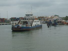
عبّارة في بنجول
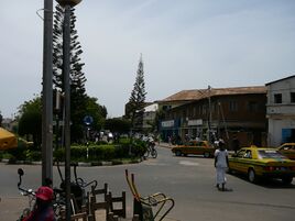
شارع في بنجول


التقسيمات الإدارية

ينقسم اقليم بانجول إلى قسمين:
المواصلات
تتصل بانجول مع جامبيا عن طريق العبارة. ويخدم المدينة مطار بانجول الدولي. وتقع بانجول على الطريقة الشاطئي الغربي لأفريقيا الذي يصلها مع داكار و بيساو وسوف يصلها مع 11 مدينة أخرى.
مدن شقيقة
 Ostend (Belgium)[15]
 Grimsby (UK)
 Newark, New Jersey (الولايات المتحدة).
 Taipei, (Taiwan) since 1997.
انظر أيضا
المصادر
- ^ "Sub-national HDI – Area Database – Global Data Lab". hdi.globaldatalab.org (in الإنجليزية). Retrieved 2018-09-13.
- ^ "The Gambia 2013 Population and Housing Census Preliminary Results" (PDF). Gambia Bureau of Statistics. Archived from the original (PDF) on 2018-07-13. Retrieved 2017-12-07.
- ^ "Gambia: The Post-Colonial Period, Part III" (in English). Gambia. Retrieved 11 December 2022.
{{cite news}}: CS1 maint: unrecognized language (link) - ^ Mane, Daouda (2021). "La Question des Origines et de l'Emergence de l'Etat de Kaabu". In Fall, Mamadou; Fall, Rokhaya; Mane, Mamadou (eds.). Bipolarisation du Senegal du XVIe - XVIIe siecle (in French). Dakar: HGS Editions. p. 251.
{{cite book}}: CS1 maint: unrecognized language (link) - ^ Arnold Hughes; David Perfect (2008). "Courland, Duchy Of". Historical Dictionary of The Gambia. Scarecrow Press. pp. 43–4. ISBN 978-0-8108-6260-9.
- ^ أ ب ت Saho, Bala (2018). Contours of Change: Muslim Courts, Women, and Islamic Society in Colonial Bathurst, the Gambia, 1905-1965. East Lansing: Michigan State University Press. pp. 45–51. ISBN 9781611862669.
- ^ أ ب "History of Banjul". Accessgambia.com. Retrieved 2012-10-29.
- ^ أ ب Arnold Hughes; David Perfect (2008). "Banjul". Historical Dictionary of The Gambia. Scarecrow Press. pp. 15–16. ISBN 978-0-8108-6260-9.
- ^ "Average Conditions Banjul, Gambia". BBC Weather. Retrieved August 16, 2009.
- ^ Bastin, Jean-Francois; Clark, Emily; Elliott, Thomas; Hart, Simon; van den Hoogen, Johan; Hordijk, Iris; Ma, Haozhi; Majumder, Sabiha; Manoli, Gabriele; Maschler, Julia; Mo, Lidong; Routh, Devin; Yu, Kailiang; Zohner, Constantin M.; Thomas W., Crowther (10 July 2019). "Understanding climate change from a global analysis of city analogues". PLOS ONE. 14 (7). S2 Table. Summary statistics of the global analysis of city analogues. Bibcode:2019PLoSO..1417592B. doi:10.1371/journal.pone.0217592. PMC 6619606. PMID 31291249.
- ^ "Cities of the future: visualizing climate change to inspire action". Current vs. future cities. Retrieved 8 January 2023.
- ^ "The CAT Thermometer". Retrieved 8 January 2023.
- ^ "Denton Bridge bridge, Banjul, Gambia". Gambia. Retrieved 2018-02-12.
- ^ "Virtual Tourist, The Gambia Transportation". Archived from the original on 2015-09-08. Retrieved 2014-05-18.
- ^ Cooperation is established in ICT-infrastructure for the B.C.C. and other projects for capacity building. Ostend-based humanitarian organisation Medios vzw is supporting the Female Surgical Ward of the Royal Victoria Teaching Hospital. (more info on http://stedenband.oostende.be)
وصلات خارجية
- Short description is different from Wikidata
- Articles with hatnote templates targeting a nonexistent page
- Articles containing Mandinka-language text
- Articles containing Fula-language text
- Coordinates on Wikidata
- مقالات ذات عبارات بحاجة لمصادر
- Articles with unsourced statements from February 2024
- بانجول
- مدن غامبيا
- عواصم أفريقيا
- Local Government Areas of the Gambia
- Populated places in the Gambia
- Capitals in Africa
- Serer country
- Populated places established in 1816
- Port cities and towns of the Atlantic Ocean
- Port cities in Africa
- Gambia River
- Former colonies of Courland
- 1816 establishments in the British Empire
- 1816 establishments in Africa