آتيراو
Atyrau
Атырау Atyraý | |
|---|---|
City | |
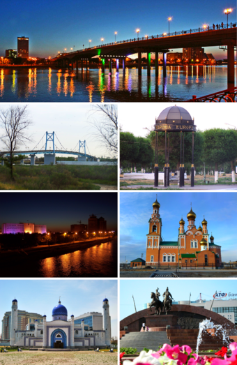 Clockwise from top: Central Bridge which connects Europe and Asia during the evening; Stand marking the European side of the city; Orthodox Church; Isatay and Makhambet Monument; Manjali Mosque; Ural River at night; Pedestrian Bridge over the Ural River. | |
| الإحداثيات: 47°07′0″N 51°53′0″E / 47.11667°N 51.88333°E | |
| Country | Kazakhstan |
| Region | Atyrau Region |
| Founded | 1640 |
| City status | 1885 |
| الحكومة | |
| • Akim (mayor) | Kairat Urazbayev (Кайрат Уразбаев) |
| المنسوب | −20 m (−70 ft) |
| التعداد (2020) | |
| • City | 290٬700 |
| • العمرانية | 355٬117 |
| منطقة التوقيت | UTC+5 (UTC+5) |
| Postal code | 060001 - 060011 |
| مفتاح الهاتف | (+7) 7122 |
| لوحة السيارة | E, 06 |
| الموقع الإلكتروني | atyrau |
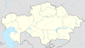
آتيراو (Atyrau ؛ بالقزخية: Атырау؛ Atyraý؛ أتيراو؛ pronounced [ɑtəˈrɑw]؛ روسية: Атырау؛ تـُنطق [ɐtɨˈraʊ])؛ عـُرِفت حتى سنة 1991 بإسم Guryev (روسية: Гурьев؛ تـُنطق [ˈɡurʲjɪf])، هي مدينة في قزخستان، وعاصمة Atyrau Region. Atyrau is a transcontinental city in Eurasia, located at the mouth of the Ural River on the Caspian Sea, in both Europe and Asia, 2,700 kilometres (1,700 miles) west of Almaty and 351 kilometres (218 miles) east of the Russian city of Astrakhan.
Modern Atyrau is famous for its oil and gas industries. It has 154,100 inhabitants (2007), up from 142,500 (1999 census), 90% ethnic Kazakhs (up from 80%), the rest being mostly Russians and other ethnic groups such as Tatars and Ukrainians.
. . . . . . . . . . . . . . . . . . . . . . . . . . . . . . . . . . . . . . . . . . . . . . . . . . . . . . . . . . . . . . . . . . . . . . . . . . . . . . . . . . . . . . . . . . . . . . . . . . . . . . . . . . . . . . . . . . . . . . . . . . . . . . . . . . . . . . . . . . . . . . . . . . . . . . . . . . . . . . . . . . . . . . . .
التاريخ
The wooden fort at the mouth of the Yaik River was founded in 1645 as Nizhny Yaitzky gorodok (literally, Lower Yaik Fort) by the Russian trader Gury Nazarov, a native of Yaroslavl, who specialized in trade with Khiva and Bukhara. The fort was plundered by the Yaik Cossacks, leading the Guriev family to rebuild it in stone (1647–62). Tsar Alexis sent a garrison of Streltsy to protect the fort from Cossack incursions. Despite these efforts, the Cossack rebel Stepan Razin held the town in 1667 and 1668. The fort gradually lost its strategic significance and was demolished in 1810. Between 1708 and 1992 the city was known as Guriev. The Kazakh name Atyraý means 'river delta'.
الجغرافيا
Atyrau (together with Aktau) is Kazakhstan's main harbour city on the Caspian Sea, Atyrau at the delta of the Ural River. Atyrau city is approximately 20 metres (66 feet) below sea level. The city is considered to be located both in Asia and Europe, as it is divided by the Ural River.
The city is a hub for the oil-rich Caspian Depression; because of this, many oil wells have been drilled in the Tengiz Field and Kashagan Field areas. An oil pipeline runs from Atyrau to Samara, where it joins the Russian pipeline system. A separate oil pipeline runs from the Tengiz field to the Russian Black Sea port of Novorossiisk.
التعداد
At the beginning of 2020, the population of the city is 290,700 people, 355,117 people in the territory of the city akimat.
National composition (at the beginning of 2020):
- Kazakhs - 313 534 people (88.29%)
- Russians - 29 466 people (8.30%)
- Koreans - 2 987 people (0.84%)
- Tatars - 1 934 people (0.54%)
- Uzbeks - 1 320 people (0.37%)
- Ukrainians - 709 people (0.20%)
- Karakalpaks - 700 people (0.20%)
- Azerbaijanis - 510 people (0.14%)
- Germans - 406 people (0.11%)
- Armenians - 357 people (0.10%)
- Dargins - 229 people (0.06%)
- Belarusians - 210 people (0.06%)
- Bulgarians - 197 people (0.06%)
- Others - 2 558 people (0.72%)
In total - 355,117 people.
أصل الاسم
Murzaev E. Dictionary of popular geographical terms (1984) states:
- "The branched coast of a large lake or sea, on which appeared the bay and islands, the estuaries of rivers and capes. The north-eastern coast of the Caspian Sea, including its alyp, the locals still call Atyrau."
A. Nurmaganbetov and M. Khobdabayev states:
- "The word atyrau, which earlier means "island", also grasps the concept of the word saga -" the mouth of the river, "and this is natural, whatever the river, at the point where it enters the ocean or the sea, its mouth branches out, and between each branch appears dry We think that this is the main reason for joint use of Atyrau together with the "mouth of the river".
Ecological Kazakh-Russian dictionary (2001) states:
- Atyrau is a tract, a cane shoal in the mouth of the Urals.
المناخ
Atyrau's climate is semi-arid (Köppen climate classification BSk), just shy of being classified as arid (Köppen climate classification BWk), with hot summers and cold winters. Precipitation is low throughout the year. Snow is common, though light in winter. The lowest temperature on record is −37.9 °C (−36.2 °F), recorded in 1909, and the highest temperature is 42.7 °C (108.9 °F), recorded in 1984.[1] It is much more continental than areas further west on the European continent, with summers characterized by temperatures averaging 33 °C (91 °F) and lack of precipitation, resembling continental hot-summer mediterranean climates, and subarctic winters with little snow but with chilling temperatures. These vast temperature swings are more comparable to Siberia and the North American plains.
| Climate data for آتيراو | |||||||||||||
|---|---|---|---|---|---|---|---|---|---|---|---|---|---|
| Month | Jan | Feb | Mar | Apr | May | Jun | Jul | Aug | Sep | Oct | Nov | Dec | Year |
| Record high °C (°F) | 10.5 (50.9) |
15.0 (59.0) |
26.3 (79.3) |
32.5 (90.5) |
38.0 (100.4) |
41.9 (107.4) |
42.7 (108.9) |
41.9 (107.4) |
40.1 (104.2) |
29.6 (85.3) |
19.9 (67.8) |
11.8 (53.2) |
42.7 (108.9) |
| Mean daily maximum °C (°F) | −2.8 (27.0) |
−1.8 (28.8) |
5.8 (42.4) |
17.2 (63.0) |
24.5 (76.1) |
30.8 (87.4) |
33.4 (92.1) |
31.6 (88.9) |
24.6 (76.3) |
15.3 (59.5) |
5.1 (41.2) |
−1.1 (30.0) |
15.2 (59.4) |
| Daily mean °C (°F) | −6.4 (20.5) |
−6.3 (20.7) |
0.8 (33.4) |
11.2 (52.2) |
18.4 (65.1) |
24.5 (76.1) |
26.8 (80.2) |
24.8 (76.6) |
18.0 (64.4) |
9.7 (49.5) |
1.3 (34.3) |
−4.3 (24.3) |
9.9 (49.8) |
| Mean daily minimum °C (°F) | −9.4 (15.1) |
−9.9 (14.2) |
−3.1 (26.4) |
6.1 (43.0) |
12.8 (55.0) |
18.4 (65.1) |
20.5 (68.9) |
18.5 (65.3) |
12.3 (54.1) |
5.0 (41.0) |
−1.7 (28.9) |
−7.0 (19.4) |
5.2 (41.4) |
| Record low °C (°F) | −37.9 (−36.2) |
−37.4 (−35.3) |
−32.3 (−26.1) |
−12.3 (9.9) |
−2.3 (27.9) |
2.3 (36.1) |
8.1 (46.6) |
4.8 (40.6) |
−5.7 (21.7) |
−15.7 (3.7) |
−29.8 (−21.6) |
−35.8 (−32.4) |
−37.9 (−36.2) |
| Average precipitation mm (inches) | 14 (0.6) |
12 (0.5) |
15 (0.6) |
16 (0.6) |
23 (0.9) |
18 (0.7) |
10 (0.4) |
12 (0.5) |
8 (0.3) |
16 (0.6) |
18 (0.7) |
14 (0.6) |
176 (6.9) |
| Average rainy days | 4 | 4 | 6 | 8 | 9 | 7 | 6 | 5 | 5 | 8 | 10 | 6 | 78 |
| Average snowy days | 14 | 11 | 7 | 1 | 0 | 0 | 0 | 0 | 0 | 1 | 5 | 11 | 50 |
| Average relative humidity (%) | 84 | 80 | 74 | 58 | 50 | 45 | 45 | 46 | 52 | 64 | 80 | 84 | 64 |
| Mean monthly sunshine hours | 98 | 138 | 167 | 245 | 311 | 330 | 343 | 323 | 267 | 196 | 105 | 75 | 2٬598 |
| Source 1: Pogoda.ru.net[1] | |||||||||||||
| Source 2: NOAA (sun, 1961–1990)[2] | |||||||||||||
. . . . . . . . . . . . . . . . . . . . . . . . . . . . . . . . . . . . . . . . . . . . . . . . . . . . . . . . . . . . . . . . . . . . . . . . . . . . . . . . . . . . . . . . . . . . . . . . . . . . . . . . . . . . . . . . . . . . . . . . . . . . . . . . . . . . . . . . . . . . . . . . . . . . . . . . . . . . . . . . . . . . . . . .
الصناعة
صناعة النفط
The third biggest refinery in Kazakhstan is located in Atyrau.[3] Atyrau Refinery is operated by KazMunayGas and has a capacity of 16,600 m³/day (2012). A deep oil refining complex is under construction which is the final stage of complete reconstruction of Atyrau Oil Refinery. This project is designed to process 2.4 million tons/year of raw materials (oil and vacuum gas oil). The project will increase the depth of the oil processing at the refinery by 2016 to 85%. The volume of oil refining will reach 5.5 million tons per year.[4]
Atyrau is located near Tengiz field, which is operated in part by Chevron.[5] Most families of Chevron employees live in Dostyk village, a compound that includes housing, recreational facilities, and an international school.[6] Atyrau also has expatriate populations working for Agip, ExxonMobil, Royal Dutch Shell, and ConocoPhillips.[7]
الرياضة
The city is home to the basketball team BC Barsy Atyrau. The team competes in the international FIBA Asia Champions Cup and the Kazakhstan Basketball Championship. It plays its home games at the Sports and Recreation complex Atyrau.
Atyrau state university, http:/asu.edu.kz/
العلاقات الدولية
البلدات التوأم
آتيراو متوأمة مع:
 Aktau, قزخستان
 أورال، قزخستان
 Aktobe, قزخستان
 Shirvan, أذربيجان
 أستراخان، روسيا
 Syktyvkar، روسيا
 أبردين، المملكة المتحدة
 أشدود، إسرائيل
 عشق آباد، تركمنستان[8]
جسور آتيراو
On August 28, 1965, the first real reinforced concrete bridge in the city, passing through the Ural River, was built and put into operation. The bridge is 259 meters (847.9 feet) long and 10 meters (32.8 feet) high. The bridge connects Satpayev Avenue and Abay Street. On the right European coast on Satpayev Avenue, the akimat (mayor's office) of the city and akimat (governor) of the Atyrau region adjoin the bridge.
In 2001, a unique pedestrian suspension bridge was built. The 551-meter (1807.7 feet)-long bridge is listed in the Guinness Book of Records as the longest pedestrian bridge in the world. From the middle of the bridge over the Urals there are views of Azattyk Avenue and its surroundings.
In 2009, the Sultan Beibars was opened - a four-lane bridge with a throughput capacity of 5–7 thousand cars a day, 800 meters (2624.6 feet) long with access roads, 380.74 meters (1249.1 feet) long and 22 meters (72.17 feet) wide. The width of the roadway is 16 meters (52.49 feet), plus two walking paths of 2.5 meters (8.2 feet) each.
انظر أيضاً
الهامش
- ^ أ ب "pogoda.ru.net Погода и Климат". Retrieved January 10, 2012.
- ^ "Atyrary (Atyrau) Climate Normals 1961–1990". National Oceanic and Atmospheric Administration. Retrieved 13 May 2015.
- ^ Company Overview of Atyrau Refinery LLP
- ^ "Japanese Banks Provide $297.5 million Loan to Atyrau Oil Refinery". The Gazette of Central Asia. Satrapia. 15 August 2012.
- ^ Affairs, Chevron Policy, Government and Public. "Kazakhstan". chevron.com. Retrieved 2016-12-06.
{{cite web}}:|first=has generic name (help)CS1 maint: multiple names: authors list (link) - ^ "DAIS | Touching Hearts Strengthening Minds". www.daiskz.org. Retrieved 2016-12-06.
- ^ "General Information". atyrau.globaloutpostservices.com. Archived from the original on 2016-12-20. Retrieved 2016-12-06.
- ^ https://tumba.kz/zhizn-regiona/11-zhizn-regiona/43012-Est_li_pobratimy_u_Aktau_i_drugih_gorodov_Kazahstan.html
وصلات خارجية
- CS1 errors: generic name
- Pages using gadget WikiMiniAtlas
- Short description is different from Wikidata
- Articles containing قزخ-language text
- Articles containing روسية-language text
- Pages using Lang-xx templates
- Articles with hatnote templates targeting a nonexistent page
- Articles with روسية-language sources (ru)
- Coordinates on Wikidata
- آتيراو
- Populated places in Atyrau Region
- Ural Oblast (Russian Empire)
- Populated places established in 1640
- أماكن مأهولة على بحر قزوين
- 1640 establishments in Russia
- مدن وبلدات في قزخستان
- Transcontinental cities
- Port cities and towns of the Caspian Sea
