ملف:Israel Railway map Hebrew English sb.svg

حجم معاينة PNG لذلك الملف ذي الامتداد SVG: 274 × 599 بكسل. البعد الآخر: 936 × 2٬048 بكسل.
الملف الأصلي (ملف SVG متحرك، بمقاسات 750 × 1٬640 بكسل، حجم الملف: 35 كيلوبايت)
ملاحظة: نظراً للقيود التقنية، فإن الصورة المصغرة لهذا الملف ستكون غير متحركة.
| Description |
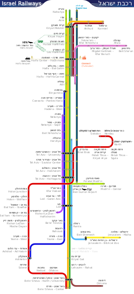
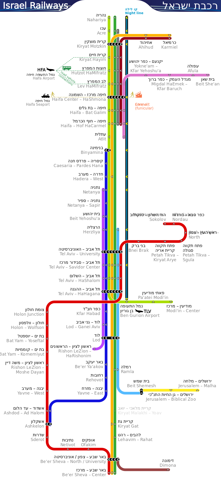
English: Map of Israel Railways passenger lines and stations in Hebrew and English. Freight lines and stations are not shown. The source SVG includes an interactive function to highlight each line in yellow dashed line individually by clicking the line itself. This effect can be cancelled globally by clicking the empty background within the image canvas. بالعبرية: מפת קווים ותחנות רכבת ישראל (באנגלית ועברית) |
|||
| Date | قالب:Upload date | |||
| Source | Own work. Generally referencing the image in Israel Railways official site, but all graphical elements in this image are done from scratch. | |||
| Author | Sameboat | |||
| ⧼wm-license-information-permission⧽ (⧼wm-license-information-permission-reusing-text⧽) |
|
|||
| ⧼wm-license-information-other-versions⧽ | قالب:PDF version available |
تاريخ الملف
اضغط على زمن/تاريخ لرؤية الملف كما بدا في هذا الزمن.
| زمن/تاريخ | صورة مصغرة | الأبعاد | مستخدم | تعليق | |
|---|---|---|---|---|---|
| حالي | ★ مراجعة معتمدة 05:25، 28 أكتوبر 2023 | | 750 × 1٬640 (35 كيلوبايت) | Pastakhov (نقاش | مساهمات) | Upload https://upload.wikimedia.org/wikipedia/commons/8/87/Israel_Railway_map_Hebrew_English_sb.svg |
لا يمكنك استبدال هذا الملف.
وصلات
لا يوجد صفحات تصل لهذه الصورة.