ساوان ناكت Savannakhet
Savannakhet
ເມືອງໄກສອນ ພົມວິຫານ Meuong Kaison Phomvihan | |
|---|---|
District and municipality | |
| Kaysone Phomvihane District | |
 The commercial centre of Kaysone Phomvihane, Savannakhet Province | |
 Savannakhet | |
| Coordinates: 16°33′N 104°45′E / 16.550°N 104.750°E | |
| Country | |
| Province | Savannakhet Province |
| Population (2018) | |
• Total | 125٬760 |
| Time zone | UTC+7 (ICT) |
Savannakhet (لاو: ສະຫວັນນະເຂດ, تـُنطق [sā.wǎn.nā(ʔ).kʰȅːt]; , officially named Kaysone Phomvihane (لاو: ໄກສອນ ພົມວິຫານ); since 2005 and previously known as Khanthaboury (لاو: ຄັນທະບູລີ), is a city in western Laos. It is the capital of Savannakhet Province. With a population of 125,760 (2018),[1] it is the second-largest city in Laos, after Vientiane. The annual per capita income of Kaysone Phomvihane City is US$2,041 (2018).[1]
Savannakhet has a large 15th-century Buddhist temple, Wat Sainyaphum, a Chinese temple, the Catholic Co-Cathedral of St. Therese and a mosque. The Second Thai–Lao Friendship Bridge over the Mekong connects to Mukdahan Province in Thailand.
Name change
The settlement of Savannakhet was formerly called Khanthaboury. Then it became Savannakhet. Its name was changed to Kaysone Phomvihane in 2005, while retaining its status as the provincial capital of Savannakhet Province. The city is the birthplace of Kaysone Phomvihane, the first leader of Laos from 1975 to 1992 after the dissolution of the Kingdom of Laos. In 2018, its status was upgraded to that of a "city". In order to attain city status, a district or municipality must be financially self-sufficient and have a population of at least 60,000 people.[1]
Transport
The Second Thai–Lao Friendship Bridge over the Mekong connects to Thailand's Mukdahan Province. The two-lane, 12-متر-wide (39 ft), 1،600-متر-long (5،250 ft) bridge opened in 2007.
The city is served by Savannakhet Airport.
Climate
Savannakhet features a tropical savanna climate (Aw) according to the Köppen climate classification.
| بيانات المناخ لـ Savannakhet (1991-2020) | |||||||||||||
|---|---|---|---|---|---|---|---|---|---|---|---|---|---|
| الشهر | ينا | فب | مار | أبر | ماي | يون | يول | أغس | سبت | أكت | نوف | ديس | السنة |
| القصوى القياسية °س (°ف) | 38.5 (101.3) |
39.5 (103.1) |
42.0 (107.6) |
41.5 (106.7) |
41.2 (106.2) |
38.0 (100.4) |
38.5 (101.3) |
36.3 (97.3) |
36.3 (97.3) |
36.0 (96.8) |
36.5 (97.7) |
38.0 (100.4) |
42.0 (107.6) |
| متوسط القصوى اليومية °س (°ف) | 29.7 (85.5) |
31.8 (89.2) |
34.2 (93.6) |
35.1 (95.2) |
33.9 (93.0) |
32.5 (90.5) |
31.2 (88.2) |
30.9 (87.6) |
31.4 (88.5) |
31.1 (88.0) |
31.2 (88.2) |
28.6 (83.5) |
31.7 (89.1) |
| المتوسط اليومي °س (°ف) | 22.2 (72.0) |
24.4 (75.9) |
27.4 (81.3) |
29.0 (84.2) |
28.8 (83.8) |
28.4 (83.1) |
27.4 (81.3) |
27.2 (81.0) |
27.3 (81.1) |
26.1 (79.0) |
24.3 (75.7) |
21.9 (71.4) |
26.2 (79.2) |
| متوسط الدنيا اليومية °س (°ف) | 15.8 (60.4) |
17.9 (64.2) |
21.7 (71.1) |
24.1 (75.4) |
25.0 (77.0) |
25.3 (77.5) |
24.6 (76.3) |
24.5 (76.1) |
24.2 (75.6) |
22.0 (71.6) |
19.2 (66.6) |
16.2 (61.2) |
21.7 (71.1) |
| الصغرى القياسية °س (°ف) | 5.8 (42.4) |
9.0 (48.2) |
10.0 (50.0) |
15.0 (59.0) |
17.5 (63.5) |
19.0 (66.2) |
18.2 (64.8) |
18.0 (64.4) |
18.0 (64.4) |
12.0 (53.6) |
8.5 (47.3) |
7.0 (44.6) |
5.8 (42.4) |
| متوسط تساقط الأمطار mm (inches) | 3.3 (0.13) |
19.3 (0.76) |
40.6 (1.60) |
69.3 (2.73) |
206.2 (8.12) |
216.5 (8.52) |
307.1 (12.09) |
333.9 (13.15) |
239.3 (9.42) |
74.2 (2.92) |
7.3 (0.29) |
4.0 (0.16) |
1٬521 (59.88) |
| Average precipitation days (≥ 1.0 mm) | 1 | 2 | 4 | 6 | 13 | 14 | 18 | 19 | 15 | 7 | 2 | 1 | 100 |
| متوسط الرطوبة النسبية (%) | 69 | 68 | 65 | 67 | 75 | 78 | 80 | 83 | 81 | 76 | 72 | 70 | 73.7 |
| Mean monthly ساعات سطوع الشمس | 246.8 | 222.4 | 225.6 | 217.4 | 191.2 | 165.0 | 142.1 | 115.9 | 154.6 | 202.8 | 225.3 | 236.9 | 2٬345٫9 |
| Source 1: NOAA (humidity, 1961-1990 and extremes)[2][3][4] | |||||||||||||
| Source 2: The Yearbook of Indochina (1932-1933)[5] | |||||||||||||
-
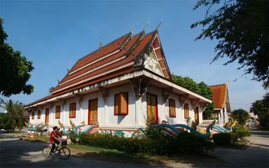 Wat Sainyaphum
 -
 Chinese Buddhist Temple
 -
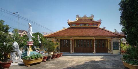 Vietnamese Buddhist Temple Diệu Giác
 -
 St. Teresa's Catholic Church


References
- ^ أ ب ت Yap, Jasmina (28 May 2018). "Town of Kaysone Phomvihane Officially Declared a City". The Laotian Times. Retrieved 30 May 2020.
- ^ "World Meteorological Organization Climate Normals for 1991-2020 — Savannakhet". National Oceanic and Atmospheric Administration. Retrieved January 17, 2024.
- ^ "Savannakhet Climate Normals 1961–1990". National Oceanic and Atmospheric Administration. Archived from the original on 17 July 2020. Retrieved 29 November 2013.
- ^ "Global Surface Summary of the Day - GSOD". National Oceanic and Atmospheric Administration. Retrieved January 26, 2023.
- ^ The Yearbook of Indochina (1932-1933)
وصلات خارجية
 Savannakhet travel guide from Wikivoyage