منطقة العاصمة الدنماركية
منطقة العاصمة الدنماركية
Region Hovedstaden | |
|---|---|
 | |
| البلد | الدنمارك |
| أكبر المدن | كوبنهاگن |
| العاصمة | هيلرود |
| البلديات | |
| الحكومة | |
| • الرئيس | Sophie Hæstorp Andersen (Social Democrats) |
| المساحة | |
| • الإجمالي | 2٬568٫29 كم² (991٫62 ميل²) |
| التعداد (1 January 2019)[1] | |
| • الإجمالي | 1٬835٬562 |
| • الكثافة | 710/km2 (1٬900/sq mi) |
| منطقة التوقيت | UTC+1 (CET) |
| • الصيف (التوقيت الصيفي) | UTC+2 (CEST) |
| GDP(nominal)[2] | 2017 |
| - الإجمالي | €120 billion ($137 billion) |
| - Per capita | €65,900 ($75,000) |
| HDI (2017) | 0.952[3] very high · 1st |
| الموقع الإلكتروني | www.regionhovedstaden.dk |
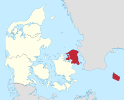
منطقة العاصمة الدنماركية (دنماركية: Region Hovedstaden) هي المنطقة الادارية الأقصى إلى الشرق في الدنمارك، تأسست في 1 يناير 2007 كجزء من الإصلاح البلدي الدنماركي 2007، الذي ألغى المقاطعات (وجمعها بالدنماركية: amter ومفردها: amt) وأنشأ خمس مناطق. وفي نفس الوقت، اندمجت البلديات الأصغر لتشكل وحدات أكبر، فخفضت عدد البلديات من 271 قبل 1 يناير 2006، حين أنشئت بلدية إرو، إلى 98. The Capital Region has 29 municipalities. The reform was implemented on January 1, 2007. The main task for the Danish regions are hospitals and healthcare. It is not to be confused with the Copenhagen Metropolitan Area nor with the Øresund Region. Unlike the counties (1970-2006) (Danish Amtskommune[da] literally county municipality) the regions are not municipalities and are thus not allowed to have coat of arms, but only logotypes, and cannot "shuffle money around" from one area of expenditure to another area of expenditure, that is, use money for any other purpose than has been stated specifically, but must pay money not used back rather like departments or agencies of the central government. The regions do not levy any taxes but are financed only through block grants.
لنمو التعداد، انظر مناطق الدنمارك.
لمعلومات حول الإصلاح، انظر بلديات الدنمارك.
Municipalities of the regions can be accessed from the Municipalities of Denmark template at the bottom of the page.
المستشفيات
The following hospitals are managed by the Capital Region of Denmark:
- Amager Hospital on the island of Amager, كوبنهاگن
- Bispebjerg Hospital في كوبنهاگن
- Bornholms Hospital on the island of Bornholm
- مستشفى فردريكسبرگ في فردريكسبرگ
- Gentofte Hospital in Gentofte
- Glostrup Hospital in Glostrup
- Herlev Hospital in Herlev
- Hvidovre Hospital in Hvidovre
- Nordsjællands Hospital in Esbønderup, Frederikssund, Hillerød, Elsinore, and Hørsholm
- Region Hovedstadens Psykiatri – psychiatric hospital with many centers around the region
- Rigshospitalet in Copenhagen
- Sct. Hans Hospital in Roskilde
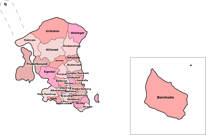
بلديات منطقة هوڤدستادن
There are 29 municipalities in the Capital Region of Denmark.
- كوبنهاگن
- فردريكسبرگ
- Albertslund
- Allerød
- Ballerup
- Bornholm
- Brøndby
- Dragør
- Egedal
- Fredensborg
- فردريكسسوند
- Furesø
- Gentofte
- Gladsaxe
- Glostrup
- Greve
- Gribskov
- Halsnæs
- Herlev
- Hillerød
- Hørsholm
- Høje-Taastrup
- Hvidovre
- Ishøj
- Lyngby-Taarbæk
- Rudersdal
- Rødovre
- Tårnby
- Vallensbæk
انظر أيضاً
المراجع
- ^ FOLK1: Population quarterly database from Statistics Denmark (دنماركية)
- ^ https://ec.europa.eu/eurostat/documents/2995521/9618249/1-26022019-AP-EN.pdf/f765d183-c3d2-4e2f-9256-cc6665909c80
- ^ "Sub-national HDI - Area Database - Global Data Lab". hdi.globaldatalab.org (in الإنجليزية). Retrieved 2018-09-13.
وصلات خارجية
 وسائط متعلقة بـRegion Hovedstaden من مشاع المعرفة.
- Official website (إنگليزية)
قالب:Danish flags 55°56.39′N 12°18′E / 55.93983°N 12.300°E
- Pages using gadget WikiMiniAtlas
- Articles with hatnote templates targeting a nonexistent page
- Short description is different from Wikidata
- Pages using infobox settlement with no coordinates
- Articles containing دنماركية-language text
- Pages using Lang-xx templates
- قوائم غير مكتملة
- Official website different in Wikidata and Wikipedia
- Coordinates on Wikidata
- منطقة العاصمة الدنماركية
- دول وأقاليم تأسست في 2007
- مناطق الدنمارك
- تأسيسات 2007 في الدنمارك


