منطقة پاردوبيتسه
Pardubice Region
Pardubický kraj | |
|---|---|
 Kunětická Hora from air | |
 Flag  Coat of arms | |
 | |
| Coordinates: 49°52′N 16°10′E / 49.87°N 16.17°E | |
| البلد | جمهورية التشيك |
| العاصمة | پاردوبيتسه |
| المقاطعات | مقاطعة پاردوبيتسه، مقاطعة خروديم، Svitavy District، Ústí nad Orlicí District |
| Government | |
| • الحاكم | Martin Netolický (ČSSD) |
| Area | |
• Total | 4٬518٫63 كم² (1٬744٫65 ميل²) |
| Highest elevation | 1٬424 m (4٬672 ft) |
| Population (2019-01-01[1]) | |
• Total | 520٬316 |
| • Density | 120/km2 (300/sq mi) |
| ISO 3166 code | CZ-PA |
| Vehicle registration | E |
| Website | www.pardubickykraj.cz |
منطقة پاردوبيتسه (تشيكية: Pardubický kraj؛ ألمانية: Pardubitzer Region؛ تـُنطق [paːʁˈdyːˈbɪt͡sɐ ʁeˈɡi̯oːn]؛ پولندية: Kraj pardubicki) هي وحدة إدارية (تشيكية: kraj) في جمهورية التشيك، located mainly in the eastern part of its historical region of Bohemia, with a small part in northwestern Moravia. It is named after its capital Pardubice. As an administrative unit, Pardubice Region has existed three times in the course of history. It was established for the first time in 1850, and extended from Český Brod to the Bohemian-Moravian border. In its second existence, it was one of 19 regions as they were set between 1949 and 1960. After 1960, Pardubice became the capital of Pardubice district, which was part of the Eastern Bohemian Region (capital Hradec Králové). The Pardubice Region, as it is now, was reestablished in 2000.
التقسيمات الإدارية
The Pardubice Region is divided into 4 districts:
 | ||||||||||
مقاطعات منطقة پاردوبيتسه
| ||||||||||
There are a total of 451 municipalities in the region (as of 2019).[2] Among these are 15 municipalities with extended powers and 26 municipalities with a delegated municipal office. Thirty-two of the municipalities are classified as towns. The regional central offices are in Pardubice.[3]
التعداد
The total population of the Pardubice Region is about 520,000. 17 municipalities have a higher population than 5,000. The largest municipality of the region is Pardubice with a population of more than 90,000. The table below shows the municipalities in Pardubice Region with the largest population (as of 1 January 2019).[2]
| الاسم | التعداد | المساحة (km2) | المقاطعة |
|---|---|---|---|
| 90,668 | 78 | مقاطعة پاردوبيتسه | |
| 23,151 | 33 | مقاطعة خروديم | |
| 16,838 | 31 | Svitavy District | |
| 15,508 | 41 | Ústí nad Orlicí District | |
| 14,196 | 36 | Ústí nad Orlicí District | |
| 12,335 | 42 | Ústí nad Orlicí District | |
| 10,429 | 33 | Svitavy District | |
| 10,070 | 42 | Svitavy District | |
| 9,991 | 21 | Ústí nad Orlicí District |
Other significant towns in Pardubice Region are Hlinsko, Přelouč, Polička, Choceň, Holice, Letohrad and Žamberk.
الجغرافيا
بمساحة 4,519 كم²، پاردوبيتسه هي خامس أصغر منطقة في جمهورية التشيك. Králický Sněžník (1,424 م) هي أعلى نقطة في المنطقة. أوطى نقطة (201 م) تقع بمنسوب سطح مياه نهر لابه (إلبه) بالقرب من Kojice.
The southern and southeastern parts of the region are home to the hilly areas of Žďárské vrchy and Železné Hory (Iron Mountains). The central and western parts of the region are formed by the Polabí lowlands. In the northeast, the region reaches the Orlické hory and Hrubý Jeseník Mountains.
The European Watershed runs through the region, where it separates the basins of the بحر الشمال and the Black Sea. The tripoint of the Danube (Black Sea), Elbe (North Sea) and Oder (Baltic Sea) watersheds is located at the peak of Králický Sněžník. The majority of the region belongs to the drainage basin of the Elbe, consisting of the rivers Chrudimka, Divoká Orlice, Doubrava, Loučná, Tichá Orlice and Třebovka. The rivers in the drainage basin of the Danube are the Morava, Moravská Sázava, Svitava and Třebůvka. The Seč Dam (220ha) and the Pastviny Dam (92ha) are among the larger water bodies in the region.
The most prevalent soil types in the region are podzol and cambisol. Forests cover 29.6% of the region and are predominantly coniferous. Deciduous forests occur around Pardubice.
المناخ
Pardubice Region has a continental climate characterized by relatively hot summers and cold winters. The climate in Pardubice Region differs depending on location. The areas in the Polabí lowlands in the western part of the region are relatively warmer with annual mean temperatures reaching 8 °C. On the other hand, the coldest areas are situated in the hilly northeastern part of the region, where the annual mean temperatures are around 4 °C.
Precipitation is relatively lower in the central part of the region where the total annual values are around 700 – 800 mm. In the areas with higher elevation (such as Žďárské Vrchy or the foothills of Orlické Hory) there is higher precipitation with annual values of 800 – 1,000 mm.
| بيانات المناخ لـ منطقة پاردوبيتسه (1961–1990) | |||||||||||||
|---|---|---|---|---|---|---|---|---|---|---|---|---|---|
| الشهر | ينا | فب | مار | أبر | ماي | يون | يول | أغس | سبت | أكت | نوف | ديس | السنة |
| المتوسط اليومي °س (°ف) | −3.1 (26.4) |
−1.4 (29.5) |
2.2 (36.0) |
7.1 (44.8) |
12.2 (54.0) |
15.3 (59.5) |
16.6 (61.9) |
16.3 (61.3) |
12.7 (54.9) |
8.0 (46.4) |
2.5 (36.5) |
−1.3 (29.7) |
7.2 (45.0) |
| متوسط تساقط الأمطار mm (inches) | 47 (1.9) |
40 (1.6) |
42 (1.7) |
46 (1.8) |
77 (3.0) |
87 (3.4) |
82 (3.2) |
84 (3.3) |
56 (2.2) |
45 (1.8) |
52 (2.0) |
54 (2.1) |
711 (28.0) |
| Source: Czech Hydrometeorological Institute[4] | |||||||||||||
الاقتصاد
The gross domestic product (GDP) per capita of the region was 81.1% of the national average in 2011. Services form the largest part of the region's economy, forming 52.4% of GDP in 2011. Other significant sectors are industry (36.9% of GDP) and construction (7.2% of GDP). The registered unemployment rate was 8.44% at the end of 2011. The highest unemployment rate was in Svitavy District.


- الصناعة
Industry and commercial public services are the basis of Pardubice's economy. General engineering, textiles, clothing, and leather processing are the strongest industrial branches. The chemical industry in Pardubice Region is larger than anywhere else in the Czech Republic.
- النقل
Road networks make up 3,597 km that transverse throughout the region. Roads I/35 and I/37 (connecting to I/17 in Chrudim) are noted as the most important. A 9 km section of the D11 motorway connect the region to Prague. The two-lane R35 expressway is planned to cross the region and connect it with Liberec, Germany and the Moravian network of highways and expressways.
There are 542 km of railways in the region, connecting it to Prague, Brno, Liberec, Olomouc, Ostrava, and to Poland. The railway corridor of Berlin – Prague – Brno – Vienna crosses the region and in Pardubice it is connected to routes of national significance to Liberec and Havlíčkův Brod.[5]
Pardubice has an international airport, operating for both public and military flights, which is listed in the category of the top 5 airports in the Czech Republic.
- الزراعة
Agriculture plays an important role in the region. The agricultural land covers about 60.2% of all land in the region, while the arable land occupies 43.8%. Forests cover 29.6% of the region.
- السياحة
Attractions from natural tourist spots (such as the Železné Hory and the Orlické Hory) to historical monuments, mostly medieval castles established since the 13th century, all encourage tourism to the region. The most significant historical monuments in the region are connected with the noble Pernštejn family from Moravia, who had two huge castles built, at Litice nad Orlicí, and on Kunětická Hora near Pardubice.[6] In 2011 there were 365 facilities providing accommodation in the region for 324,000 visitors.
التعليم والرعاية الصحية
In 2011 there were:
- 309 kindergartens with 17,994 students
- 251 elementary schools with 41,184 students
- 21 secondary elementary schools (Czech: gymnázium) with 6,305 students
- 55 high schools with 16,413 students
- 10 colleges (Czech: vyšší odborná škola) with 1,135 students
- University of Pardubice with seven faculties and more than 10,000 students.
Furthermore, there were nine hospitals with a capacity of 2,584 patients. In total, there were 2,009 doctors in the region and the patient-per-doctor ratio was 257.
معالم
- National Breeding Stud at Kladruby nad Labem
- Králíky and Králický Sněžník National Nature Reserve
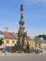
- Kunětická Hora Castle
- Lanškroun Ponds Nature Park
- Letohrad and its Museum of Crafts
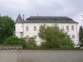
- Litomyšl with the Renaissance Chateau
- Nové Hrady Chateau
- پاردوبيتسه with the Pardubice Chateau and Grand Pardubice Steeplechase
- Svojanov Castle
- Veselý Kopec, the largest collection of folk architecture in Bohemia
- Železné Hory National Geopark
معرض صور
-
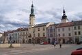
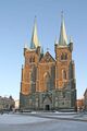 خروديم
 -
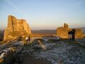
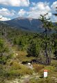 Kralický Sněžník
 -
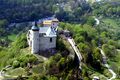 Kunětická Hora Castle
 -
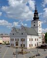 Lanškroun Town Hall
 -
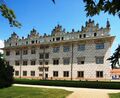 Litomyšl Chauteau
 -
 Moravská Třebová
 -
 Nové Hrady Chauteau
 -
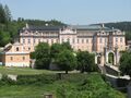
 Pardubice Chauteau
 -
 Polička
 -
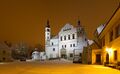
 Slatiňany Castle
 -
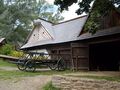 Veselý Kopec
 -
 Železné Mountains


المراجع
- ^ "Population of territorial units of the Czech republic". Czech Statistical Office. Retrieved 2019-04-30.
- ^ أ ب "Population of municipalities of the Czech republic". Czech Statistical Office. Retrieved 2019-04-30.
- ^ The Pardubice Region Archived 9 يوليو 2007 at the Wayback Machine, Official site, Retrieved 14 April 2011
- ^ "Historická data – meteorologie a klimatologie". Czech Hydrometeorological Institute. Archived from the original on 14 October 2013. Retrieved 8 September 2013.
- ^ East-Bohemia.info, Official tourist portal of the Pardubice region, Retrieved 8 December 2012
- ^ "Archived copy". Archived from the original on 9 July 2007. Retrieved 8 December 2011.
{{cite web}}: CS1 maint: archived copy as title (link)