شلالات كايتيور
| كايتيور | |
|---|---|
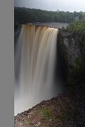
 كايتيور، گويانا، في موسم الأمطار، 2004. | |
 | |
 | |
| الموقع | گويانا |
| الإحداثيات | 5°10′30″N 59°28′49.8″W / 5.17500°N 59.480500°W |
| النوع | Plunge |
| الارتفاع | 4380 م. |
| إجمالي الارتفاع | 226 متر |
| عدد المساقط | 1 (أعلى شلال تدفق منفرد في العالم) |
| أعلى مسقط | 226 متر |
| المجرى المائي | نهر پوتارو |
| متوسط معدل التدفق | 660 م³ |
| الترتيب العالمي للارتفاع | 123 |
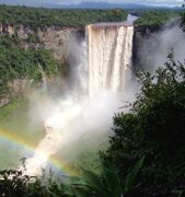
شلالات كايتيور (Kaieteur Falls)، هو شلال single-drop[1] على نهر پوتارو في منتزه كايتيور الوطني، إقليم إسكيبو الأوسط، گويانا. يبلغ ارتفاع الشلال 226 متراً عند قياسه من نقطة الهبوط فوق جرف الحجر الرملي والرصيص حتى الانكسار الأول. بعد ذلك يتدفق الشلال فوق سلسلة من الشلالات شديدة الانحدار والتي، عند تضمينها في القياسات، يصل الارتفاع الإجمالي لشلالات كايتيور إلى 251 مترًا. في حين أن العديد من الشلالات لها ارتفاع أكبر، فإن القليل منها يجمع بين الارتفاع وحجم الماء، ويعتبر كايتيور من بين أقوى الشلالات في العالم حيث يبلغ متوسط معدل التدفق 663 مترًا مكعبًا في الثانية.[2] يبلغ ارتفاع شلالات كايتيور أربع أضعاف ونص ارتفاع شلالات نياگرا، على الحدود بين كندا والولايات المتحدة، وحوالي ضعف ارتفاع شلالات ڤيكتوريا، على الحدود بين زامبيا وزيمبابوي في أفريقيا.
أعلى النهر وراء الشلالات، تمتد هضبة پوتارو إلى منحدر بعيد عن جبال پاكارايما. يصب نهر پوتارو في نهر إيسكيبو ويحتل الترتيب 34 كأطول نهر في أمريكا الجنوبية ويعد أطول نهر في گويانا.
التاريخ والاكتشاف
Long known about by Indigenous nations in the area, the falls were noticed by Europeans in 1870 by a party led by Charles Barrington Brown, a British geologist appointed as a government surveyor to the colony of British Guiana. Brown and his partner James Sawkins had arrived in Georgetown in 1867, and while they did some of their mapping and preparation of geological reports together, some work was performed in separate expeditions, and Sawkins was taking a break from his work at the time of Brown's discovery of Kaieteur. At this point, Brown did not have time to investigate Kaieteur Falls closely, so he returned one year later to make comprehensive measurements. Brown's book Canoe and Camp life in British Guiana was published in 1876. Two years later, in 1878, he published Fifteen Thousand Miles on the Amazon and its tributaries.
According to a Patamona Indian legend, Kaieteur Falls was named for Kai, a chief, or Toshao who acted to save his people by paddling over the falls in an act of self-sacrifice to Makonaima, the great spirit. Another legend though was told to Brown by Amerindians in the night of discovery of falls: Kaieteur has been named after an unpleasant old man who was placed in a boat and shoved in the fall by his relatives. Thus, the fall was named "Kaieteur", which means "old-man-fall".
السياحة
Kaieteur Falls is a major tourist attraction in Guyana. It is in Kaieteur National Park in the centre of Guyana's rainforest. The park is served by Kaieteur International Airport, about a 15-minute walk from the top of Kaieteur falls, with frequent flights to Ogle Airport and Cheddi Jagan International Airport in Georgetown.
الثقافة الشعبية
Kaieteur Falls is featured in:
- the documentary film The White Diamond by Werner Herzog and Animal Planet's River Monsters with Jeremy Wade.
- the science fiction animation television series G Gundam. The lead character trains and bathes under the falls before his final fight.
- the opening of the fourth season credits of the Discovery Channel's series "Gold Rush" (2013). It also features in the body of a few episodes of that season.
- episode 6 of David Attenborough's series Life on Earth in which the native frogs, which thrive in the moist conditions, are discussed.
- episode 1 of Steve Backshall's series Deadly Adventures where Steve abseils to the bottom and camps overnight.
- the ending of the final episode of the fourth season of River Monsters features the falls.
- Evelyn Waugh's 1934 travel book, Ninety-two Days.
انظر أيضاً
معرض الصور
-
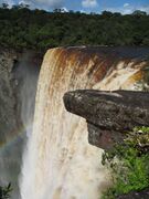
 شلالات كايتيور في سبتمبر 2007.
 -
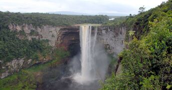 شلالات كايتيور في موسم الجفاف، فبراير 2007.
 -
 شلالات كايتيور، سبتمبر 2007.
 -
 شلالات كايتيور، 2006.
 -
 شلالات كايتيور، ديسمبر 2018.
 -
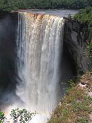
 شلالات كايتيور، 2004.

_2007.jpg&filetimestamp=20231105015530&)


مرئيات
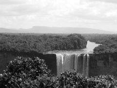
| صورة لجوية لشلالات كايتيور، گويانا. |
المصادر
- ^ "Kaieteur Falls - World Waterfall Database".
- ^ "Kaieteur Falls - World Waterfall Database". Archived from the original on 2017-10-10. Retrieved 2008-12-02.
وصلات خارجية
- منتزه كايتيور الوطني
- شلالات كايتيور
- شلالات كايتيور في بيوتيفل ورلد