مستكشف حقل الجاذبية والحالة المستقرة لدوران المحيطات
(تم التحويل من گوس (ساتل))
| قمر | الأرض |
|---|---|
| تاريخ الاقلاع | March 17, 2009 |
| مركبة الإطلاق | روكوت |
| صفحة الإنترنت | www.esa.int |
| الكتلة | 1،100 kg (2،400 lb) |
| العناصر المدارية | |
| اختلاف المركز | Near circular |
| زاوية ميلان | 96.70° |
| Periapsis | 270 km (170 mi) |
مستكشف حقل الجاذبية والحالة المستقرة لدوران المحيطات Gravity Field and Steady-State Ocean Circulation Explorer (GOCE) هو ساتل تابع لوكالة الفضاء الاوروبية، اطلق في 17 مارس 2009.[1] ويحمل گراديوميتر فائق الحساسية للجاذبية يرصد التغيرات الدقيقة في الكثافة في القشرة الأرضية وفي محيطات الأرض.
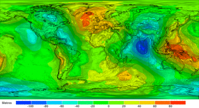
يهدف بشكل أساسي لقياس حقل الجاذبية الأرضي المستقر وإنشاء نموذج عالي الدقة للجيوئيد geoid.
أهداف المهمة
- تحديد دقة شذوذ الجاذبية الأرضية بدقة واحد ميلي گال (گال هو وحدة قياس للتسارع حيث أنه واحد گال = 0.01 متر /ثانية مربع ).
- تحديد الجيوئيد بدقة واحد إلى اثنين سنتيمتر.
- انجاز هذه الأهداف في منطقة من الأرض لا تتجاوز مئة كيلومتر.
خصائصه

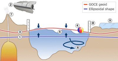
رسم خرائط للتأثيرات المختلفة للجاذبية.
1. Earth is a slightly flattened sphere - it is ellipsoidal in shape 2. Goce senses tiny variations in the pull of gravity over Earth 3. The data is used to construct an idealised surface, or geoid 4. It traces gravity of equal 'potential'; balls won't roll on its 'slopes' 5. It is the shape the oceans would take without winds and currents 6. So, comparing sea level and geoid data reveals ocean behaviour 7. Gravity changes can betray magma movements under volcanoes 8. A precise geoid underpins a universal height system for the world 9. Gravity data can also reveal how much mass is lost by ice sheets المصدر: [2]
1. Earth is a slightly flattened sphere - it is ellipsoidal in shape 2. Goce senses tiny variations in the pull of gravity over Earth 3. The data is used to construct an idealised surface, or geoid 4. It traces gravity of equal 'potential'; balls won't roll on its 'slopes' 5. It is the shape the oceans would take without winds and currents 6. So, comparing sea level and geoid data reveals ocean behaviour 7. Gravity changes can betray magma movements under volcanoes 8. A precise geoid underpins a universal height system for the world 9. Gravity data can also reveal how much mass is lost by ice sheets المصدر: [2]
- الارتفاع عن سطح الأرض 250 كيلومتر , و هذا الارتفاع المنخفض يمكنه من تحديد الجيوئيد بدقة.
- مدار متزامن مع الشمس, بانحناء inclination قدره 96.5 درجة.
- سيتم الإطلاق من موقع پلستسك Plesetsk Cosmodrome في روسيا.
- المحطة الأرضية في كيرونا Kiruna في السويد ستسخدم لتبادل الأوامر و المعلومات, و المركز الأوروبي للعمليات الفضائية ESOC في دارمشتات الألمانية ستستخدم لمراقبة القمر الصناعي.
- يبلغ وزن هذا القمر ألف كيلوگرام, وطوله خمسة متر.
القوة

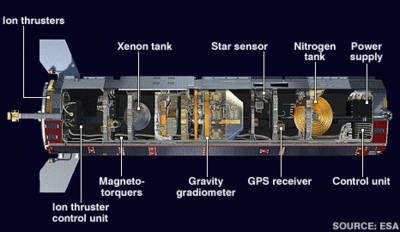
رسم خرائط للتأثيرات المختلفة للجاذبية. The 1,100kg Goce is built from rigid materials and carries fixed solar wings. The gravity data must be clear of spacecraft 'noise' The 5m-by-1m frame incorporates fins to stabilise the spacecraft as it flies through the residual air in the thermosphere Goce's accelerometers measure accelerations that are as small as 1 part in 10,000,000,000,000 of the gravity experienced on Earth The UK-built engine ejects xenon ions at velocities exceeding 40,000m/s; the engine throttles up and down to keep Goce at a steady altitude المصدر: [2]
انظر أيضاً
- Gravity Recovery and Climate Experiment (GRACE) NASA - launch 2002
- Ice, Cloud, and land Elevation Satellite (ICESat) NASA - launch 2003
- Soil Moisture and Ocean Salinity satellite (SMOS) ESA - launch 2009
- CryoSat-2 ESA - launch 2010
الهامش
- ^ GOCE site, ESA, http://www.esa.int/SPECIALS/GOCE/index.html, retrieved on 2009-03-04
- ^ أ ب ت Jonathan Amos (2010-06-28). "Goce satellite views Earth's gravity in high definition". BBC.
وصلات خارجية
- ESA GOCE site
- ESA's gravity mission GOCE
- GOCE page at ESA Spacecraft Operations
- GOCE Mission Profile by NASA's Solar System Exploration
- Jonathan Amos (27 July 2007), 'Space arrow' to map Earth's tug, BBC News, http://news.bbc.co.uk/1/hi/sci/tech/6919016.stm
- 24 October 2008 BBC News story
- 6 April 2009 BBC News story
- http://www.earthzine.org/2007/10/29/esa’s-earth-observation-programmes-advancing-earth-science-through-new-sensing-technology
This article contains content from Wikimedia licensed under CC BY-SA 4.0. Please comply with the license terms.

