نقاش القالب:Geobox/Protected area
Geobox|Protected area
| Mendip Hills | |
| Protected area | |
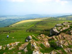
The Mendip Hills from Crook Peak, near Compton Bishop.
| |
| البلد | England |
|---|---|
| County | Somerset |
| Districts | North Somerset, Mendip, Sedgemoor, Bath & North East Somerset |
| Settlements | Wells, Cheddar |
| الاحداثيات | 51°18′N 2°44′W / 51.300°N 2.733°W |
| أعلى نقطة | Beacon Batch |
| - المنسوب | 325 m (1،066 ft) |
| - الإحداثيات | 51°18′43″N 2°44′28″W / 51.31194°N 2.74111°W |
| الطول | 30 km (19 mi), East–West |
| الاتساع | 10 km (6 mi), North–South |
| المساحة | 200 km2 (77 sq mi) |
| - SSSI | 25 km2 (10 sq mi) |
| - Nature Reserve | 10 km2 (4 sq mi) |
| - National Trust | 71 km2 (27 sq mi) |
| - Somerset Wildlife Trust | 28 km2 (11 sq mi) |
| Biome | Calcareous grassland |
| الجيولوجيا | Limestone, Karst, Caves |
| النباتات | Geranium purpureum, Galium fleurotii, Dianthus gratianopolitanus, Helianthemum apenninum |
| الحيوانات | Peregrine Falcon, Long-eared Owl, Greater Horseshoe Bat, Downy Emerald, White-clawed Crayfish, Hazel Dormouse |
| تأسست | 1972 |
| Management | Mendip Hills AONB Partnership |
| - location | Charterhouse, Somerset |
| - الاحداثيات | 51°17′58″N 2°43′40″W / 51.29944°N 2.72778°W |
| الموقع: www.mendiphillsaonb.org.uk | |
Geobox Protected Area

