ميلتون كينز
| Milton Keynes | |
|---|---|
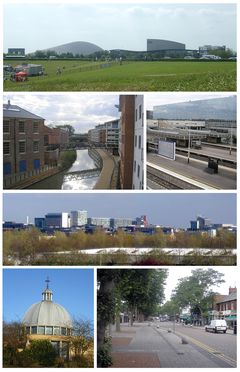
 Top to bottom, left to right: The Xscape and Theatre seen from Campbell Park; former railway works and new housing in Wolverton; Milton Keynes Central railway station; the Central Milton Keynes skyline; the central ecumenical Church of Christ the Cornerstone; and Bletchley's high street "Queensway". | |
Location within Buckinghamshire | |
| Area | 89 km2 (34 sq mi) |
| Population | 229٬941 (2011 Urban Area)[1] |
| • Density | 2،584/km2 (6،690/sq mi) |
| OS grid reference | SP841386 |
| • London | 50 mi (80 km)[أ] SSE |
| Unitary authority | |
| Ceremonial county | |
| Region | |
| Country | England |
| Sovereign state | United Kingdom |
| Post town | MILTON KEYNES |
| Postcode district | MK1–15, MK17, MK19 |
| Dialling code | 01908 |
| Police | Thames Valley |
| Fire | Buckinghamshire |
| Ambulance | South Central |
| EU Parliament | South East England |
| UK Parliament | |
| Website | www |
ميلتون كينز (Milton Keynes ؛ /ˌmɪltən ˈkiːnz/ (![]() استمع) mil-tən-KEENZ)، وتُعرف للمحليين بالاختصار MK، هي بلدة كبيرة[note 1] في بكنگهامشاير، إنگلترة. وهي المركز الاداري لـمركز ميلتون كينز وأُعلنت رسمياً بلدة جديدة في 23 يناير 1967،[5] with the design brief لتصبح "مدينة" مصغرة. وتقع على بعد 45 ميل (72 km) شمال غرب لندن.
استمع) mil-tən-KEENZ)، وتُعرف للمحليين بالاختصار MK، هي بلدة كبيرة[note 1] في بكنگهامشاير، إنگلترة. وهي المركز الاداري لـمركز ميلتون كينز وأُعلنت رسمياً بلدة جديدة في 23 يناير 1967،[5] with the design brief لتصبح "مدينة" مصغرة. وتقع على بعد 45 ميل (72 km) شمال غرب لندن.
عند التصميم، تم تخصيص مساحة 89 كم² تصم بلدات بلتشلي وولڤرتون و ستوني ستراتفورد، بجانب خمسة عشر قرية ومزرعة أخرى بينهم. وأخذت اسمها من قرية ميلتون كينز الموجودة بالفعل، على بعد أميال قليلة شرق المركز المزمع.
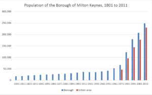
في تعداد 2011، كان تعداد ميلتون كينز، المنطقة الحضرية، بما في ذلك نيوپورت پاگنل و ووبرن ساندز هو 229,941 نسمة،[1] وتعداد المركز الأكبر، الذي كان سلطة أحادية استقلت عن مقاطعة بكنگهامشاير منذ 1997، هو 248,800 نسمة،[6] بالمقارنة بتعداد يناهز 53,000 لنفس المنطقة في 1961.[7]
التاريخ
مولد "مدينة جديدة"
في ع1960، قررت الحكومة البريطانية أن هناك حاجة إلى جيل إضافي من البلدات الجديدة في جنوب شرق إنگلترة لتخفيف الاكتظاظ السكاني عن لندن.
منذ ع1950، أقيمت مشاريع إسكان لاستيعاب الانفجار السكاني في أحياء لندن في بلتشلي.[8][9][10] المزيد من الدراسات[11][12] في ع1960 اختارت شمال بكنگهامشاير كموقع ممكن لإنشاء بلدة جديدة كبيرة، أو مدينة جديدة،[13] تضم البلدات التي كانت متواجدة بالفعل: بلتشلي وستوني ستراتفورد و ولڤرتون. البلدة الجديدة (سُمِّيت بشكل غير رسمي في وثائق التخطيط "المدينة الجديدة") كان المفترض أن تكون الأكبر بين المدن الجديدة، بتعداد يناهز ربع مليون نسمة،[14] في "منطقة مخصصة" مساحتها 21،850 acre (34.1 sq mi; 88.4 km2).[15] الاسم "ميلتون كينز" أُخِذ من قرية ميلتون كينز في الموقع.[16]
The site was deliberately located equidistant from London, Birmingham, Leicester, Oxford and Cambridge with the intention[17] that it would be self-sustaining and eventually become a major regional centre in its own right. Planning control was taken from elected local authorities and delegated to the Milton Keynes Development Corporation (MKDC).
التاريخ السابق
أقرب المدن والبلدات والقرى
البلدات التوأم
المناخ
Milton Keynes experiences an oceanic climate (Köppen climate classification Cfb) similar to almost all of the United Kingdom. Recorded temperature extremes range from 34.6 °C (94.3 °F)[19] during July 2006, to as low as −20.6 °C (−5.1 °F)[20] on 25 February 1947. More recently the temperature fell to −16.3 °C (2.7 °F)[21] on 20 December 2010
The nearest Met Office weather station is in Woburn,[22] located just outside the south eastern fringe of the Milton Keynes urban area.
| بيانات المناخ لـ Woburn 1981–2010 (Weather station 3 mi (5 km) to the SE of وسط ميلتون كينز) | |||||||||||||
|---|---|---|---|---|---|---|---|---|---|---|---|---|---|
| الشهر | ينا | فب | مار | أبر | ماي | يون | يول | أغس | سبت | أكت | نوف | ديس | السنة |
| متوسط القصوى اليومية °س (°ف) | 7.0 (44.6) |
7.4 (45.3) |
10.3 (50.5) |
13.1 (55.6) |
16.6 (61.9) |
19.6 (67.3) |
22.1 (71.8) |
21.9 (71.4) |
18.7 (65.7) |
14.4 (57.9) |
10.0 (50.0) |
7.2 (45.0) |
14.1 (57.4) |
| متوسط الدنيا اليومية °س (°ف) | 1.3 (34.3) |
0.9 (33.6) |
2.7 (36.9) |
3.8 (38.8) |
6.5 (43.7) |
9.4 (48.9) |
11.7 (53.1) |
11.6 (52.9) |
9.6 (49.3) |
7.0 (44.6) |
3.8 (38.8) |
1.5 (34.7) |
5.8 (42.4) |
| متوسط تساقط الأمطار mm (inches) | 54.2 (2.13) |
41.7 (1.64) |
45.3 (1.78) |
52.1 (2.05) |
54.3 (2.14) |
53.2 (2.09) |
53.1 (2.09) |
55.4 (2.18) |
57.5 (2.26) |
70.3 (2.77) |
63.0 (2.48) |
57.3 (2.26) |
657.4 (25.88) |
| Mean monthly ساعات سطوع الشمس | 52.0 | 69.4 | 105.5 | 147.4 | 183.4 | 179.9 | 197.1 | 189.0 | 137.0 | 105.6 | 61.7 | 43.5 | 1٬471٫6 |
| Source: Met Office[23] | |||||||||||||
انظر أيضاً
ملاحظات
- ^ Although Milton Keynes was specified to be a city in scale and the term "city" is used locally (inter alia to avoid confusion with its constituent towns), formally this title cannot be used. This is because conferment of وضع مدينة في المملكة المتحدة هي Royal prerogative.
الهامش
- ^ أ ب قالب:NOMIS2011
- ^ According to a nearby historic milestone.
- ^ "Engineer's Line References". RailwayCodes.org. 28 July 2018. Retrieved 15 February 2019.
- ^ "Central Milton Keynes to Charing Cross". Google Maps. Retrieved 15 February 2019.
- ^ ""North Buckinghamshire (Milton Keynes) New Town (Designation) Order", London Gazette, 24 January 1967, page 827". London Gazette. Retrieved 14 January 2014..
- ^ "Census 2011". Office for National Statistics. Retrieved 25 August 2012.
{{cite journal}}: Cite journal requires|journal=(help) - ^ Vision of Britain: historic census populations for modern Milton Keynes UA Accessed 11 October 2006
- ^ "Bletchley Pioneers, Planning, & Progress". Clutch.open.ac.uk. 16 December 1944. Retrieved 23 November 2012.
- ^ "Welcome to Adobe GoLive 4". Clutch.open.ac.uk. Retrieved 23 November 2012.
- ^ Need for more planned towns in the South-East.The Times. 2 December 1964 Accessed 21 September 2006
- ^ South East Study 1961–1981 HMSO 1964, cited in The Plan for Milton Keynes. Retrieved 25 September 2006
- ^ Urgent action to meet London housing needs. The Times, 4 February 1965. Retrieved 21 September 2006
- ^ Volume 1 of The Plan for Milton Keynes (Milton Keynes Development Corporation March 1970 ISBN 0-903379-00-7 begins (in the Foreword by Lord ("Jock") Campbell of Eskan): "This plan for building the new city of Milton Keynes ..." (page xi) Accessed 25 September 2006
- ^ Area of New Town Increased by 6،000 acre (24 km2). The Times. 14 January 1966. Retrieved 21 September 2006
- ^ "MK Council General Statistics". Milton Keynes Council. Retrieved 10 April 2008.
- ^ Llewelyn-David et al. The Plan for Milton Keynes 1968. Retrieved 11 January 2007
- ^ The South East Study 1961–1981 HMSO London, 1964: "A big change in the economic balance within the south east is needed to modify the dominance of London and to get a more even distribution of growth". Retrieved 27 November 2006
- ^ "Crrescendo: Combined rational and renewable energy strategies in cities, for existing and new dwellings and optimal quality of life". Cordis.europe.eu. Retrieved 23 November 2012.
- ^ "2006 Maximum". Metoffice.gov.uk. Retrieved 3 March 2011.
- ^ "1947 minimum". doi:10.1002/wea.66.
{{cite journal}}: Cite journal requires|journal=(help) - ^ Rogers, Simon (21 December 2010). "2010 minimum". The Guardian. London. Retrieved 3 March 2011.
- ^ "Synoptic and climate stations – February 2012 – Met Office". Met Office. Retrieved 23 November 2012.
- ^ "Woburn 1981–2010 averages". Met Office. Retrieved 29 November 2012.
وصلات خارجية
- Milton Keynes at the Open Directory Project
- Milton Keynes news, what's on and community portal
- Official visitor website for Milton Keynes
- Milton Keynes Council
- City Discovery Centre (MK urban studies centre)
- Urban Design magazine – "Milton Keynes at 40"
- Community Forum for Milton Keynes Borough
- Milton Keynes in 1968, on BFI Player
قالب:Buckinghamshire
قالب:River Great Ouse
خطأ استشهاد: وسوم <ref> موجودة لمجموعة اسمها "lower-alpha"، ولكن لم يتم العثور على وسم <references group="lower-alpha"/>
- Pages using gadget WikiMiniAtlas
- Short description is different from Wikidata
- Articles with OS grid coordinates
- Coordinates on Wikidata
- Pages including recorded pronunciations
- Pages with empty portal template
- أماكن مأهولة على نهر آوس الأكبر
- بلدات في بكنگهامشاير
- ميلتون كينز
- بلدات جديدة في إنگلترة
- أماكن مأهولة تأسست في 1967
- مدن مخططة في إنگلترة
- Articles including recorded pronunciations (UK English)


