ملف:Runit Dome 001.jpg

حجم هذه المعاينة: 475 × 599 بكسل. البعد الآخر: 1٬493 × 1٬883 بكسل.
الملف الأصلي (1٬493 × 1٬883 بكسل حجم الملف: 468 كيلوبايت، نوع MIME: image/jpeg)
| Description |
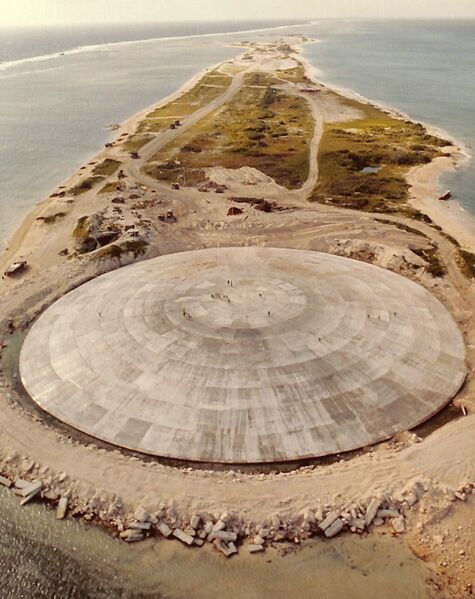
English: Runit Dome (or Cactus Dome), Runit Island, Enewetak Atoll. Aerial view. In 1977-1980 the crater created by the Cactus shot of Operation Hardtack I was used as a burial pit to inter 84,000 cubic meters of radioactive soil scraped from the various contaminated Enewetak Atoll islands. The Runit Dome was built to cover the material.
Français : Cactus Dome, île Runit, atoll d'Enewetak. Vue aérienne. En 1977-1980 le cratère créé par le test nucléaire américain Cactus de l'opération Hardtack I a été utilisé pour enfouir 84.000 mètres cubes de sol radioactif provenant des îles contaminés de l'atoll. Le Cactus Dome est un dôme de béton recouvrant les déchets. |
| Date | 1980 |
| Source | http://sonicbomb.com/albums/album61/runit.jpg |
| Author | US Defense Special Weapons Agency |
| ⧼wm-license-information-permission⧽ (⧼wm-license-information-permission-reusing-text⧽) |
قالب:PD-USGov-Military |
تاريخ الملف
اضغط على زمن/تاريخ لرؤية الملف كما بدا في هذا الزمن.
| زمن/تاريخ | صورة مصغرة | الأبعاد | مستخدم | تعليق | |
|---|---|---|---|---|---|
| حالي | ★ مراجعة معتمدة 19:17، 12 أكتوبر 2023 | | 1٬493 × 1٬883 (468 كيلوبايت) | Pastakhov (نقاش | مساهمات) | Upload https://upload.wikimedia.org/wikipedia/commons/e/ea/Runit_Dome_001.jpg |
لا يمكنك استبدال هذا الملف.
وصلات
الصفحات التالية تحتوي على وصلة لهذه الصورة: