مقاطعة گراند، كولورادو
Grand County | |
|---|---|
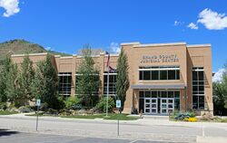
 The Grand County Judicial Center in Hot Sulphur Springs, July 2016 | |
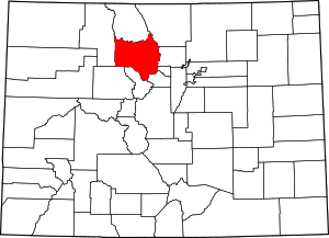
 الموقع ضمن ولاية Colorado | |
 موقع Colorado ضمن الولايات المتحدة | |
| الإحداثيات: 40°06′N 106°07′W / 40.10°N 106.12°W | |
| البلد | |
| State | |
| تأسست | February 2, 1874 |
| السمِيْ | Grand Lake and Grand River |
| Seat | Hot Sulphur Springs |
| أكبر town | Granby |
| المساحة | |
| • الإجمالي | 1٬870 ميل² (4٬800 كم²) |
| • البر | 1٬846 ميل² (4٬780 كم²) |
| • الماء | 23 ميل² (60 كم²) 1.2%% |
| التعداد | |
| • Estimate (2019) | 15٬734 |
| • الكثافة | 8٫0/sq mi (3٫1/km2) |
| منطقة التوقيت | UTC−7 (Mountain) |
| • الصيف (التوقيت الصيفي) | UTC−6 (MDT) |
| Congressional district | 2nd |
| الموقع الإلكتروني | co |
مقاطعة گراند إنگليزية: Grand County هي إحدى مقاطعات ولاية كولورادو في الولايات المتحدة الأمريكية. وفي تعداد الولايات المتحدة 2010 بلغ تعداد سكانها 14,843 نسمة.[1] The county seat is Hot Sulphur Springs.[2]

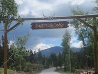
Scenic vehicle entrance to Grand Lake Lodge (established 1919), included on the National Register of Historic Places
السياسة
نتائج الانتخابات الرئاسية
| السنة | جمهوريون | ديمقراط | غيرهم |
|---|---|---|---|
| 2020 | 49.5% 4,883 | 47.7% 4,710 | 2.8% 277 |
| 2016 | 52.3% 4,494 | 39.1% 3,358 | 8.6% 736 |
| 2012 | 52.0% 4,253 | 45.0% 3,684 | 3.1% 250 |
| 2008 | 49.7% 4,128 | 48.6% 4,037 | 1.7% 144 |
| 2004 | 56.0% 4,260 | 42.6% 3,243 | 1.4% 106 |
| 2000 | 56.2% 3,570 | 36.3% 2,308 | 7.5% 475 |
| 1996 | 46.3% 2,264 | 41.2% 2,012 | 12.6% 614 |
| 1992 | 35.9% 1,763 | 34.1% 1,678 | 30.0% 1,477 |
| 1988 | 60.1% 2,306 | 37.8% 1,451 | 2.1% 81 |
| 1984 | 72.7% 2,865 | 25.8% 1,017 | 1.5% 58 |
| 1980 | 61.3% 2,133 | 23.6% 820 | 15.2% 528 |
| 1976 | 61.8% 1,703 | 33.0% 910 | 5.2% 144 |
| 1972 | 69.9% 1,721 | 27.8% 685 | 2.2% 55 |
| 1968 | 67.4% 1,167 | 25.0% 433 | 7.6% 132 |
| 1964 | 47.2% 814 | 52.3% 902 | 0.5% 8 |
| 1960 | 62.6% 1,104 | 37.3% 657 | 0.1% 2 |
| 1956 | 71.3% 1,239 | 28.6% 496 | 0.1% 2 |
| 1952 | 70.3% 1,333 | 29.2% 554 | 0.4% 8 |
| 1948 | 49.7% 777 | 48.9% 763 | 1.4% 22 |
| 1944 | 63.5% 968 | 36.4% 554 | 0.1% 2 |
| 1940 | 55.2% 1,074 | 44.4% 863 | 0.5% 9 |
| 1936 | 45.5% 714 | 54.0% 846 | 0.5% 8 |
| 1932 | 42.9% 598 | 55.3% 771 | 1.9% 26 |
| 1928 | 62.2% 770 | 36.4% 451 | 1.5% 18 |
| 1924 | 54.3% 681 | 24.6% 308 | 21.1% 265 |
| 1920 | 52.5% 649 | 44.7% 553 | 2.8% 34 |
| 1916 | 37.2% 378 | 61.4% 624 | 1.5% 15 |
| 1912 | 25.8% 248 | 52.7% 507 | 21.5% 207 |
التجمعات
البلدات
أماكن مذكور بالتعداد
غيرهم
انظر أيضاً
- List of counties in Colorado
- Saratoga County, Jefferson Territory
- National Register of Historic Places listings in Grand County, Colorado
الهامش
- ^ "State & County QuickFacts". United States Census Bureau. Archived from the original on June 6, 2011. Retrieved January 25, 2014.
- ^ "Find a County". National Association of Counties. Archived from the original on 2011-05-31. Retrieved 2011-06-07.
- ^ Leip, David. "Dave Leip's Atlas of U.S. Presidential Elections". uselectionatlas.org. Retrieved May 26, 2017.
وصلات خارجية
- Official website
- Arapaho National Recreation Area website
- Colorado County Evolution by Don Stanwyck
- Colorado Historical Society
- Grand County Library District website
- Grand County News website
- Grand County Tourism Board website
- Town of Hot Sulphur Springs website
- Rocky Mountain National Park website
- Winter Park and Fraser Valley Chamber of Commerce website
- Grand Lake Chamber of Commerce homepage
- WorkInGrand Portal

|
لاريمر | Jackson County and راوت | 
| |
| Gilpin County and بولدر | ||||
| كلير كريك | سمت | إيگل |
?
تصنيفات:
- Pages using gadget WikiMiniAtlas
- Short description is different from Wikidata
- Coordinates on Wikidata
- مقاطعات Colorado
- Articles containing إنگليزية-language text
- Pages using Lang-xx templates
- Portal-inline template with redlinked portals
- Pages with empty portal template
- مقاطعة گراند، كولورادو
- تأسيسات 1874 في إقليم كولورادو
- أماكن مأهولة في 1874
- مقاطعات كولورادو
