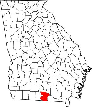
مقاطعة لاوندز، جورجيا
Lowndes County | |
|---|---|
 Lowndes County Courthouse in Valdosta | |
 الموقع ضمن ولاية Georgia | |
 موقع Georgia ضمن الولايات المتحدة | |
| الإحداثيات: 30°50′N 83°16′W / 30.83°N 83.27°W | |
| البلد | |
| State | |
| تأسست | December 23, 1825 |
| السمِيْ | William Jones Lowndes |
| Seat | Valdosta |
| أكبر مدينة | Valdosta |
| المساحة | |
| • الإجمالي | 511 ميل² (1٬320 كم²) |
| • البر | 496 ميل² (1٬280 كم²) |
| • الماء | 15 ميل² (40 كم²) 2.8%% |
| التعداد (2010) | |
| • الإجمالي | 112٬865 |
| • الكثافة | 220/sq mi (80/km2) |
| منطقة التوقيت | UTC−5 (Eastern) |
| • الصيف (التوقيت الصيفي) | UTC−4 (EDT) |
| Congressional districts | 1st، 8th |
| الموقع الإلكتروني | www |
مقاطعة لاونديز إنگليزية: Lowndes County هي إحدى المقاطعات في ولاية جورجيا في الولايات المتحدة الأمريكية.
الترفيه
التجمعات السكنية
المدن
Town
Census-designated place
Unincorporated communities
- Bandy
- Barretts
- Beloteville
- Bemiss
- Blanton
- Cat Creek
- Clyattville
- Delmar
- Eddy
- Franklinville (historic)
- Little Miami
- Long Pond
- Lowndesville (historic)
- Haines
- Indianola
- Kinderlou
- Mars
- Melrose
- Mineola
- Olympia (historic)
- Ousley
- Quillian
- Naylor
- Ralls
- Redland
- Sims
- Stella
- Tillman
- Troupville
- Twin Lakes
Politics
| Year | Republican | Democratic | Third Parties |
|---|---|---|---|
| 2016 | 57.2% 21,635 | 39.9% 15,064 | 2.9% 1106 |
| 2012 | 54.4% 21,327 | 44.5% 17,470 | 1.1% 424 |
| 2008 | 54.2% 21,269 | 44.8% 17,597 | 1.0% 384 |
| 2004 | 59.9% 18,981 | 39.5% 12,516 | 0.6% 187 |
| 2000 | 56.9% 14,462 | 41.7% 10,616 | 1.4% 354 |
| 1996 | 48.9% 10,578 | 43.8% 9,470 | 7.3% 1576 |
| 1992 | 46.3% 10,276 | 40.6% 9,019 | 13.1% 2897 |
| 1988 | 62.6% 10,855 | 37.1% 6,427 | 0.3% 51 |
| 1984 | 62.9% 10,437 | 37.1% 6,167 | |
| 1980 | 51.3% 6,622 | 46.4% 5,989 | 2.3% 301 |
| 1976 | 33.8% 4,512 | 66.2% 8,830 | |
| 1972 | 79.5% 7,812 | 20.5% 2,015 | |
| 1968 | 27.6% 3,073 | 21.5% 2402 | 50.9% 5,679 |
| 1964 | 61.0% 6,811 | 39.0% 4,363 | 0.0% 1 |
| 1960 | 44.7% 2,908 | 55.4% 3,605 | |
| 1956 | 35.2% 2,135 | 64.8% 3,936 | |
| 1952 | 39.1% 2,079 | 61.0% 3,245 | |
| 1948 | 36.6% 1,448 | 47.2% 1,867 | 16.3% 643 |
| 1944 | 16.1% 401 | 83.9% 2,092 | |
| 1940 | 9.2% 260 | 90.4% 2,551 | 0.4% 11 |
| 1936 | 4.0% 130 | 94.9% 3,099 | 1.1% 37 |
| 1932 | 5.0% 97 | 94.7% 1,840 | 0.4% 7 |
| 1928 | 29.7% 596 | 70.3% 1,413 | |
| 1924 | 4.7% 57 | 90.4% 1,095 | 4.9% 59 |
| 1920 | 14.4% 220 | 85.6% 1,308 | |
| 1916 | 4.4% 88 | 92.7% 1,870 | 3.0% 60 |
| 1912 | 3.9% 35 | 93.5% 847 | 2.7% 24 |
See also
References
وصلات خارجية
- Lowndes County
- Lowndes County Schools
- Documents from Lowndes County at the Digital Library of Georgia
- Valdosta Wake Compound

|
Lanier County | Berrien County | Cook County | 
|
| Echols County | Brooks County | |||
| Hamilton County, Florida | Madison County, Florida |
الكلمات الدالة:
?
تصنيفات:
- Pages using gadget WikiMiniAtlas
- Short description is different from Wikidata
- Georgia (U.S. state) counties
- Articles containing إنگليزية-language text
- Pages using Lang-xx templates
- Pages using div col with unknown parameters
- Pages with empty portal template
- Coordinates on Wikidata
- Lowndes County, Georgia
- مقاطعات ولاية جورجيا
- Valdosta metropolitan area counties
- 1825 establishments in Georgia (U.S. state)
- Populated places established in 1825
