مقاطعة شرمان، أوريگون
Sherman County | |
|---|---|
 Sherman County Courthouse in Moro | |
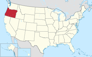
 الموقع ضمن ولاية Oregon | |
 موقع Oregon ضمن الولايات المتحدة | |
| الإحداثيات: 45°25′N 120°41′W / 45.41°N 120.69°W | |
| البلد | |
| State | |
| تأسست | February 25, 1889 |
| Seat | Moro |
| أكبر مدينة | Wasco |
| المساحة | |
| • الإجمالي | 831 ميل² (2٬150 كم²) |
| • البر | 824 ميل² (2٬130 كم²) |
| • الماء | 7٫5 ميل² (19 كم²) 0.9%% |
| التعداد (2010) | |
| • الإجمالي | 1٬765 |
| • Estimate (2019) | 1٬780 |
| • الكثافة | 2٫1/sq mi (0٫8/km2) |
| منطقة التوقيت | UTC−8 (Pacific) |
| • الصيف (التوقيت الصيفي) | UTC−7 (PDT) |
| Congressional district | 2nd |
| الموقع الإلكتروني | co |
مقاطعة شرمان إنگليزية: Sherman County هي إحدى مقاطعات ولاية أوريگون في الولايات المتحدة.
التاريخ

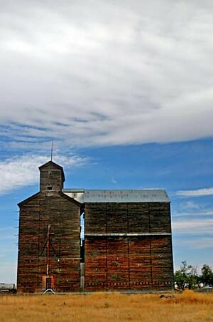
Old grain elevator in Kent
المقاطعات المجاورة
- Klickitat County, Washington - north
- Gilliam County - east
- Wasco County - southwest
الديمغرافيا
| التعداد | Pop. | ملاحظة | %± |
|---|---|---|---|
| 1890 | 1٬792 | — | |
| 1900 | 3٬477 | 94�0% | |
| 1910 | 4٬242 | 22�0% | |
| 1920 | 3٬826 | −9٫8% | |
| 1930 | 2٬978 | −22٫2% | |
| 1940 | 2٬321 | −22٫1% | |
| 1950 | 2٬271 | −2٫2% | |
| 1960 | 2٬446 | 7٫7% | |
| 1970 | 2٬139 | −12٫6% | |
| 1980 | 2٬172 | 1٫5% | |
| 1990 | 1٬918 | −11٫7% | |
| 2000 | 1٬934 | 0٫8% | |
| 2010 | 1٬765 | −8٫7% | |
| 2019 (تق.) | 1٬780 | [1] | 0٫8% |
| U.S. Decennial Census[2] 1790-1960[3] 1900-1990[4] 1990-2000[5] 2010-2019[6] | |||
الحكومة والبنية التحتية
The Northern Oregon Regional Corrections Facility (Norcor), a short-term jail, serves Sherman, Gilliam, Hood River, and Wasco counties.[7]
نتائج الانتخابات الرئاسية
| Year | Republican | Democratic | Third parties |
|---|---|---|---|
| 2020 | 76.2% 921 | 21.5% 260 | 2.2% 27 |
| 2016 | 72.0% 732 | 19.9% 202 | 8.2% 83 |
| 2012 | 66.1% 678 | 31.1% 319 | 2.8% 29 |
| 2008 | 60.6% 634 | 36.8% 385 | 2.7% 28 |
| 2004 | 62.9% 694 | 35.3% 390 | 1.8% 20 |
| 2000 | 63.9% 679 | 30.7% 326 | 5.4% 57 |
| 1996 | 44.6% 476 | 41.6% 444 | 13.8% 147 |
| 1992 | 38.0% 424 | 32.4% 362 | 29.6% 330 |
| 1988 | 54.6% 555 | 42.8% 435 | 2.6% 26 |
| 1984 | 67.5% 828 | 32.4% 398 | 0.1% 1 |
| 1980 | 57.9% 677 | 33.3% 389 | 8.9% 104 |
| 1976 | 51.1% 567 | 44.3% 491 | 4.6% 51 |
| 1972 | 64.9% 677 | 31.6% 330 | 3.5% 36 |
| 1968 | 59.3% 646 | 35.3% 384 | 5.4% 59 |
| 1964 | 36.5% 494 | 63.5% 859 | 0.0% 0 |
| 1960 | 56.6% 659 | 43.4% 506 | 0.0% 0 |
| 1956 | 61.5% 671 | 38.5% 420 | 0.0% 0 |
| 1952 | 67.5% 747 | 32.1% 355 | 0.5% 5 |
| 1948 | 53.2% 532 | 45.4% 454 | 1.4% 14 |
| 1944 | 47.7% 475 | 52.0% 518 | 0.3% 3 |
| 1940 | 46.1% 575 | 53.7% 670 | 0.2% 3 |
| 1936 | 27.8% 337 | 67.9% 823 | 4.4% 53 |
| 1932 | 38.0% 423 | 59.8% 665 | 2.2% 24 |
| 1928 | 66.4% 759 | 32.8% 375 | 0.9% 10 |
| 1924 | 55.9% 756 | 27.1% 367 | 16.9% 229 |
| 1920 | 65.6% 893 | 31.1% 423 | 3.4% 46 |
| 1916 | 46.9% 717 | 48.8% 747 | 4.3% 66 |
| 1912 | 34.9% 244 | 33.1% 232 | 32.0% 224 |
| 1908 | 58.3% 437 | 33.6% 252 | 8.1% 61 |
| 1904 | 71.1% 701 | 16.5% 163 | 12.4% 122 |
الاقتصاد
Sherman County is predominantly an agricultural county, its economy receiving some aid from ranching and tourism. Its farms primarily produce wheat and barley. It is also home to the Biglow Canyon Wind Farm, the largest project of its kind in Oregon.[9]
التجمعات
المدن
- Grass Valley
- Moro (county seat)
- Rufus
- Wasco
Census-designated place
Other unincorporated communities
انظر أيضاً
الهامش
- ^ "Population and Housing Unit Estimates". Retrieved مارس 26, 2020.
- ^ "U.S. Decennial Census". United States Census Bureau. Retrieved فبراير 28, 2015.
- ^ "Historical Census Browser". University of Virginia Library. Retrieved فبراير 28, 2015.
- ^ Forstall, Richard L., ed. (مارس 27, 1995). "Population of Counties by Decennial Census: 1900 to 1990". United States Census Bureau. Retrieved فبراير 28, 2015.
- ^ "Census 2000 PHC-T-4. Ranking Tables for Counties: 1990 and 2000" (PDF). United States Census Bureau. أبريل 2, 2001. Retrieved فبراير 28, 2015.
- ^ خطأ استشهاد: وسم
<ref>غير صحيح؛ لا نص تم توفيره للمراجع المسماةQF - ^ "Norcor Home Archived نوفمبر 24, 2011 at the Wayback Machine." Northern Oregon Regional Corrections Facility. Retrieved on November 22, 2011.
- ^ Leip, David. "Dave Leip's Atlas of U.S. Presidential Elections". uselectionatlas.org. Retrieved أبريل 11, 2018.
- ^ Hill, Gail Kinsey. Wind farm in gorge may blow others away. The Oregonian. August 1, 2005.
للاستزادة
- Giles French, The Golden land : a history of Sherman County, Oregon.Portland, OR: Champoeg Press, 1958.
- Sherman County Historical Society, A Guide to Oregon Trails in Sherman County, Oregon. Moro, OR: Sherman County Historical Society, 1993.
- An Illustrated History of Central Oregon, Embracing Wasco, Sherman, Gilliam, Wheeler, Crook, Lake, and Klamath Counties, State of Oregon. Spokane, WA: Western Historical Publishing Co., 1905.
الصحف
- Moro Bulletin.
- Moro Leader. (1898— )
- Moro Observer/Sherman County Observer. (1897—1931)
- Sherman County Journal. (1931— )
- Sherman County News. (1927— )

|
Klickitat County, Washington | 
| ||
| Gilliam County | مقاطعة واسكو | |||
| Wasco County |
الكلمات الدالة:
?
تصنيفات:
- Pages using gadget WikiMiniAtlas
- Short description is different from Wikidata
- Use mdy dates from December 2021
- Coordinates on Wikidata
- مقاطعات Oregon
- Pages using infobox U.S. county with unknown parameters
- Articles containing إنگليزية-language text
- Pages using Lang-xx templates
- Pages using US Census population needing update
- Pages with empty portal template
- Portal-inline template with redlinked portals
- مقاطعة شرمان، أوريگون
- تأسيسات 1889 في أوريگون
- Populated places established in 1889
- Columbia River Gorge
- مقاطعات أوريگون


