قالب:جدول محافظة تركية/doc
| هذه صفحة توثيق فرعية لـ قالب:جدول محافظة تركية. تتضمن معلومات الاستعمال، التصنيفات وأي محتوى آخر ليس من محتويات الأصل لصفحة القالب. |
Example usage
Izmir | |
|---|---|
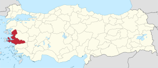
 موقع محافظة Izmir في تركيا | |
| [[File:{{{خريطة_الأقضية}}}|320px|أقضية محافظة Izmir]] أقضية محافظة Izmir | |
| البلد | تركيا |
| المنطقة | Aegean |
| العاصمة | Izmir |
| الحكومة | |
| • المحافظ | Mustafa Cahit Kıraç |
| المساحة | |
| • الإجمالي | 11٬973 كم² (4٬623 ميل²) |
| التعداد (2010-12-31)[1] | |
| • الإجمالي | 3٬769٬000 |
| • الكثافة | 310/km2 (820/sq mi) |
| مفتاح الهاتف | 0232 |
| لوحة السيارة | 35 |
| الموقع الإلكتروني | izmir.gov.tr |
The wikicode below will create the infobox to the right:
{{Infobox Province TR
|name       = Izmir
|map        = Izmir in Turkey.svg
|region     = Aegean
|area       = 11,973
|total population = 3,769,000
|tpop_as_of = 2007
|licence    = 35
|area_code  = 232
|governor   = Mustafa Cahit Kıraç
|website    = [http://www.izmir.gov.tr/ izmir.gov.tr]
}}
- Notes
- name= (Name of the province-without "Province" word)
- map= Name of file
- turkname= If different than Name.(Name of the province-without "Province" word) with Turkish letters
- region = region of X(Aegean,Black Sea, Central Anatolia, Eastern Anatolia, Marmara, Mediterranean, Southeastern Anatolia)
- area= Area of the province (in km2-without "km2")
- total population= (Total population of the province-only numbers, ie;3,500,000)
- popdens= (Population density of province; "Total Pop/area"-two decimal digits)
- tpop_ref= (Reference of Total population)
- tpop_as_of= (Census year of Total population, ie;2005)
- urban population= (Urban population of the province-only numbers, ie;3,500,000)
- upop_ref= (Reference of Urban population)
- upop_as_of= (Census year of Urban population, ie;2005)
- rural population= (Rural-district population of the province-only numbers, ie;3,500,000)
- rpop_ref= (Reference of Rural population)
- rpop_as_of= (Census year of Rural population, ie;2005)
- licence= (Plate licence code of the province-only numbers)
- area_code= (Area code-call prefix- of the province-only numbers, ex; 212)
- governor= (Name and Surname of the Governor of the province)
- website= (Web address of the Governorate of the province;ex; "http://www.ankara.gov.tr")
Microformat
The HTML mark up produced by this template includes an hCard microformat, which makes the place-name and location parsable by computers, either acting automatically to catalogue article across Wikipedia, or via a browser tool operated by a person, to (for example) add the subject to an address book. Within the hCard is a Geo microformat, which additionally makes the coordinates (latitude & longitude) parsable, so that they can be, say, looked up on a map, or downloaded to a GPS unit. For more information about the use of microformats on Wikipedia, please see the microformat project.
hCard uses HTML classes including:
- "adr"
- "county-name"
- "fn"
- "label"
- "locality"
- "nickname"
- "note"
- "org"
- "region"
- "street-address"
- "vcard"
Geo is produced by calling {{coord}}, and uses HTML classes:
- "geo"
- "latitude"
- "longitude"
Please do not rename or remove these classes.
When giving coordinates, please don't be overly precise.
المراجع
- ^ Turkish Statistical Institute, MS Excel document – Population of province/district centers and towns/villages and population growth rate by provinces