قاعدة پايا لبار الجوية
Paya Lebar Air Base (PLAB) Pangkalan Udara Paya Lebar 巴耶利峇空军基地 (Bā Yé Lì Bā Kōngjūn Jīdì) பாய ளேபர் வான்படைத் தளம் (Pāya Lēpar Vāṉpaṭait Taḷam) | |||||||||||
|---|---|---|---|---|---|---|---|---|---|---|---|
 Paya Lebar Air Base Crest Badge | |||||||||||
| الملخص | |||||||||||
| نوع المطار | Military airbase | ||||||||||
| المالك | Ministry of Defence (Singapore) | ||||||||||
| المشغل | Republic of Singapore Air Force | ||||||||||
| الموقع | Paya Lebar, Singapore | ||||||||||
| المنسوب AMSL | 65 ft / 20 m | ||||||||||
| الإحداثيات | 01°21′37″N 103°54′34″E / 1.36028°N 103.90944°E | ||||||||||
| Runways | |||||||||||
| |||||||||||
Paya Lebar Air Base (PLAB) (IATA: QPG, ICAO: WSAP) is a military airbase of the Republic of Singapore Air Force located at Paya Lebar, in the central-eastern part of Singapore, the airbase goes by the motto of "Strength Through Readiness".
Originally built in 1954 as Singapore International Airport to replace Kallang Airport, control of the airport was transferred to RSAF in 1980 when it was renamed Paya Lebar Air Base, following the relocation of the civilian airport to Changi.
التاريخ

معرض صور
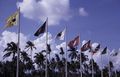
Flags outside Singapore International Airport, photographed February 1969 × July 1971.
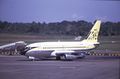
Malaysia-Singapore Airlines Boeing 737
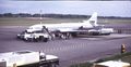
SAS airliner at Singapore International Airport, photographed February 1969 × July 1971.
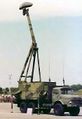
1988, a GIRAFFE S 3D radar on display at Paya Lebar Air Base.
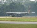
An RSAF C-130H performing short field landing at PLAB.
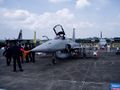
An AGM-65 Maverick armed Northrop F-5S Tiger-II.
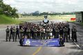
2008, Squadron personnel and staff of 149 Sqn based at PLAB posing in front of the squadron's F-5S Tiger-IIs after winning the Best RSAF Unit award. In 2010, the Sqn transitioned to the new F-15SG Strike Eagles.


See also
References
- ^ Airport information for WSAP at World Aero Data. Source: DAFIF.
- ^ Airport information for QPG at Great Circle Mapper. Data current as of October 2006. Source: DAFIF (effective Oct. 2006).
وصلات خارجية
| Overflight photo 1 of Paya Lebar Airport, 1962 | |
| Overflight photo 2 of Paya Lebar Airport, 1962 | |
| Overflight photo 3 of Paya Lebar Airport, 1962 | |
- Missing redirects
- Short description is different from Wikidata
- Articles containing صينية-language text
- Pages using gadget WikiMiniAtlas
- Pages with empty portal template
- Military airbases established in 1955
- Airports in Singapore
- Camps and bases of the Singapore Armed Forces
- Paya Lebar
- Republic of Singapore Air Force bases
- 1955 establishments in Malaya
- Singapore–United States military relations