الغات الغربية
| Western Ghats | |
|---|---|
| Sahyadri | |
 Western Ghats as seen from Gobichettipalayam, Tamil Nadu | |
| أعلى نقطة | |
| القمة | Anamudi, Eravikulam National Park |
| الارتفاع | 2,695 m (8,842 ft) |
| الأبعاد | |
| الطول | 1,600 km (990 mi) N–S |
| العرض | 100 km (62 mi) E–W |
| المساحة | 160,000 km2 (62,000 sq mi) |
| الجغرافيا | |
| البلد | India |
| الولايات | Gujarat, Maharashtra, Goa, Karnataka, Kerala and Tamil Nadu |
| المناطق | Western India and Southern India |
| التجمعات | Mumbai, Pune, Coimbatore, Kochi, Thiruvanthapuram, Kozhikode, Surat and Belgaum |
| الحيوم | Tropical and subtropical moist broadleaf forests |
| الجيولوجيا | |
| عمر الصخر | Cenozoic |
| نوع الصخر | Basalt, Laterite and Limestone |
| الاسم الرسمي | Natural Properties - Western Ghats (India) |
| النوع | Natural |
| المعيار | ix, x |
| التوصيف | 2012 (36th session) |
| الرقم المرجعي | 1342 |
| الدولة العضو | الهند |
| المنطقة | شبه الجزيرة الهندية |
الغات الغربية Western Ghats (وتُعرف أيضاً بإسم ساهيادري وتعني الجبال الرحيمة) هي سلسلة جبال تجري موازية للساحل الغربي لشبه الجزيرة الهندية، وتقع بالكامل في الهند. It is a UNESCO World Heritage Site and is one of the eight "hottest hot-spots" of biological diversity in the world.[1][2] It is sometimes called the Great Escarpment of India.[3] The range runs north to south along the western edge of the Deccan Plateau, and separates the plateau from a narrow coastal plain, called Konkan, along the Arabian Sea. A total of thirty nine properties including national parks, wildlife sanctuaries and reserve forests were designated as world heritage sites - twenty in Kerala, ten in Karnataka, five in Tamil Nadu and four in Maharashtra.[4][5]
The range starts near the border of Gujarat and Maharashtra, south of the Tapti river, and runs approximately 1,600 km (990 mi) through the states of Maharashtra, Goa, Karnataka, Kerala and Tamil Nadu ending at Kanyakumari, at the southern tip of India. These hills cover 160,000 km2 (62,000 sq mi) and form the catchment area for complex riverine drainage systems that drain almost 40% of India. The Western Ghats block southwest monsoon winds from reaching the Deccan Plateau.[6] The average elevation is around 1,200 m (3,900 ft).[7]
The area is one of the world's ten "Hottest biodiversity hotspots" and has over 7,402 species of flowering plants, 1,814 species of non-flowering plants, 139 mammal species, 508 bird species, 179 amphibian species, 6,000 insects species and 290 freshwater fish species; it is likely that many undiscovered species live in the Western Ghats. At least 325 globally threatened species occur in the Western Ghats.[8][9][10]
. . . . . . . . . . . . . . . . . . . . . . . . . . . . . . . . . . . . . . . . . . . . . . . . . . . . . . . . . . . . . . . . . . . . . . . . . . . . . . . . . . . . . . . . . . . . . . . . . . . . . . . . . . . . . . . . . . . . . . . . . . . . . . . . . . . . . . . . . . . . . . . . . . . . . . . . . . . . . . . . . . . . . . . .
الجيولوجيا
الطبوغرافيا

القمم


Following is a list of some of the highest peaks of the Western Ghats:
| الترتيب | الاسم | الارتفاع | الموقع |
|---|---|---|---|
| 1 | Anaimudi | 2,695 m (8,842 ft) | Eravikulam National Park, Kerala |
| 2 | Mannamalai | 2,659 m (8,724 ft) | Idukki, Kerala |
| 3 | Meesapulimala | 2,640 m (8,660 ft) | Idukki, Kerala |
| 4 | Doddabetta | 2,637 m (8,652 ft) | Nilgiris, Tamil Nadu |
| 5 | Kolaribetta | 2,629 m (8,625 ft) | Mukurthi National Park, Tamil Nadu |
| 6 | Mukurthi | 2,554 m (8,379 ft) | Mukurthi National Park, Tamil Nadu |
| 7 | Vandaravu | 2,553 m (8,376 ft) | Palani Hills, Tamil Nadu |
| 8 | Kattumala[11] | 2,552 m (8,373 ft) | Eravikulam National Park, Kerala |
| 9 | Anginda peak | 2,383 m (7,818 ft) | Silent Valley National Park, Kerala |
| 10 | Vavulmala[12] | 2,339 m (7,674 ft) | Vellarimala, Kerala |
| 11 | Kodaikanal | 2,133 m (6,998 ft) | Kodaikanal, Tamil Nadu |
| 12 | Chembra Peak | 2,100 m (6,900 ft) | Wayanad, Kerala |
| 13 | Elivai Mala[13] | 2,088 m (6,850 ft) | Palakkad, Kerala |
| 14 | Banasura Peak | 2,073 m (6,801 ft) | Wayanad, Kerala |
| 15 | Kottamala | 2,019 m (6,624 ft) | Periyar National Park, Kerala |
| 16 | Mullayanagiri | 1,930 m (6,330 ft) | Chikmagalur, Karnataka |
| 17 | Devarmala | 1,923 m (6,309 ft) | Achenkovil, Kerala |
| 18 | Baba Budangiri | 1,895 m (6,217 ft) | Chikmagalur, Karnataka |
| 19 | Kudremukh | 1,894 m (6,214 ft) | Chikmagalur, Karnataka |
| 20 | Agasthyamala | 1,868 m (6,129 ft) | Thiruvananthapuram, Kerala |
| 21 | Biligiriranga Hills | 1,800 m (5,900 ft) | Chamarajanagar, Karnataka |
| 22 | Velliangiri Mountains[14] | 1,778 m (5,833 ft) | Coimbatore, Tamil Nadu |
| 23 | Tadiandamol | 1,748 m (5,735 ft) | Kodagu, Karnataka |
| 24 | Kumara Parvata | 1,712 m (5,617 ft) | Dakshina Kannada, Karnataka |
| 25 | Pushpagiri | 1,712 m (5,617 ft) | Pushpagiri Wildlife Sanctuary, Karnataka |
| 26 | Merthi Gudda | 1,676 m (5,499 ft) | Hornadu, Karnataka |
| 27 | Kalsubai | 1,648 m (5,407 ft) | Ahmednagar, Maharashtra |
| 28 | Brahmagiri | 1,608 m (5,276 ft) | Kodagu, Karnataka |
| 29 | Kote Betta | 1,620 m (5,310 ft) | Kodagu, Karnataka |
| 30 | Salher | 1,567 m (5,141 ft) | Nashik, Maharashtra |
| 31 | Madikeri | 1,525 m (5,003 ft) | Kodagu, Karnataka |
| 32 | Dhodap | 1,472 m (4,829 ft) | Nashik, Maharashtra |
| 33 | Himavad Gopalaswamy Betta | 1,450 m (4,760 ft) | Chamarajanagar, Karnataka |
| 34 | Taramati | 1,431 m (4,695 ft) | Ahmednagar, Maharashtra |
| 35 | Torna Fort | 1,405 m (4,610 ft) | Pune, Maharashtra |
| 36 | Purandar fort | 1,387 m (4,551 ft) | Pune, Maharashtra |
| 37 | Raigad fort | 1,346 m (4,416 ft) | Raigad, Maharashtra |
| 38 | Kodachadri | 1,343 m (4,406 ft) | Shimoga, Karnataka |
| 39 | Paithalmala | 1,372 m (4,501 ft) | Kannur, Kerala |
| 40 | Vagamon | 1,100 m (3,600 ft) | Idukki, Kerala |
المسطحات المائية


المناخ

حماية التنوع الحيوي


. . . . . . . . . . . . . . . . . . . . . . . . . . . . . . . . . . . . . . . . . . . . . . . . . . . . . . . . . . . . . . . . . . . . . . . . . . . . . . . . . . . . . . . . . . . . . . . . . . . . . . . . . . . . . . . . . . . . . . . . . . . . . . . . . . . . . . . . . . . . . . . . . . . . . . . . . . . . . . . . . . . . . . . .
الوحيش
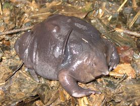
- الثدييات
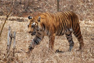
Western Ghats has the largest tiger population outside Sunderbans
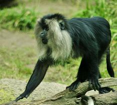
Endangered Lion-tailed macaque is endemic to Western Ghats

Western Ghats region has the largest فيل هندي population in India
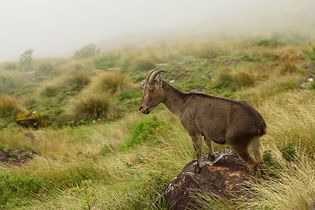
Only 100 individuals of Nilgiri tahr were left in 2001 but has recovered to 3,300 by 2010
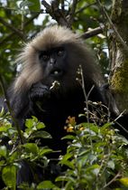
The endemic Nilgiri langur is endangered


.jpg)

_by_N._A._Naseer.jpg)
- الزواحف
- البرمائيات

The region has significant population of vulnerable Mugger crocodile
Purple frog (Nasikabatrachus sahyadrensis) was discovered in 2003
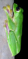
Malabar gliding frog is endemic to Western Ghats
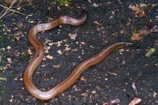
Pipe snakes are found only in South India and Sri Lanka
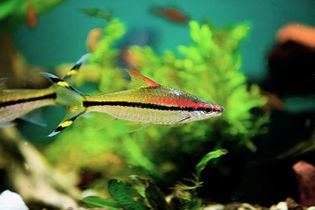
Denison's barb is threatened from habitat loss and is now bred in captivity


- الأسماك
- الطيور


_-_Male_-_Sakleshpur_-_India_-2009.jpg)


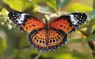
- الحشرات
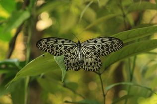
The Malabar tree nymph is endemic to the Western Ghats
Tamil Lacewings are found only in South Asia
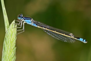
The Western Ghats has 67 species of damselflies
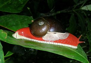
The endemic land snail Indrella ampulla
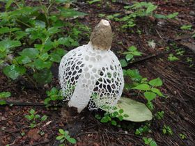
Phallus indusiatus found in the Western Ghats


- المحار
حصن كالافانتين دورج
يعد حصن "كالافانتين دورج"، الواقع على قمة تل مرتفع، نصبًا معماريًا فريدًا. في كل عام، يكون له اهتمام كبير بالعديد من عشاق رياضة المشي لمسافات طويلة. للتغلب على الصعود إلى القمة لمدة ثلاث ساعات، فهي بحاجة إلى قدر لا بأس به من القدرة على التحمل واللياقة البدنية، لأنه يتعين على المسافرين تسلق الدرج الضيق لسلالم مقطوعة في منحدر حاد.
حصن "كالافانتين دورج" هو جزء من حصون بانهالغادا، التي شيدتها سلالة شيلهار في مطلع القرنين الثاني عشر والثالث عشر في المواقع الأكثر أهمية من الناحية الاستراتيجية. لأولئك المحظوظين الذين لديهم القوة الكافية لتسلق قمة التل، منظر طبيعي بجمال مذهل مع إطلالة رائعة على مومباي والحصون المجاورة.[15]
مرئيات
| رحلة إلى قمة كالافانتين دورج واحدة من أكثر الرحلات صعوبة في الغات الغربية، الهند. الطريق إلى قمة كالافانتين انحدار 60 درجة تقريبًا. |
الهامش
- ^ "Biodiversity hotspots for conservation priorities". Nature. Retrieved 16 Nov 2013.
- ^ "UN designates Western Ghats as world heritage site". Times of India. 2 July 2012. Retrieved 2 July 2012.
- ^ Migon, Piotr (12 May 2010). Geomorphological Landscapes of the World. Springer. p. 257. ISBN 978-90-481-3054-2.
- ^ "Western Ghats". UNESCO. Retrieved 3 January 2013.
- ^ Lewis, Clara (3 July 2012). "39 sites in Western Ghats get world heritage status". Times of India. Retrieved 21 February 2013.
- ^ Vijayan, V.S. "Research needs for the Western Ghats" (PDF). Ashoka Trust for Research in Ecology and the Environment (ATREE). Retrieved 21 June 2007.
{{cite journal}}: Cite journal requires|journal=(help) - ^ "The Peninsula". Asia-Pacific Mountain Network. Archived from the original on 12 August 2007. Retrieved 19 March 2007.
- ^ Nayar, T.S.; Rasiya Beegam, A; Sibi, M. (2014). Flowering Plants of the Western Ghats, India (2 Volumes). Thiruvananthapuram, India: Jawaharlal Nehru Tropical Botanic Garden and Research Institute. p.1700.
- ^ Myers, N.; Mittermeier, R.A.; Mittermeier, C.G.; Fonseca, G.A.B.Da; Kent, J. (2000). "Biodiversity Hotspots for Conservation Priorities". Nature. 403: 853–858. doi:10.1038/35002501. PMID 10706275.
- ^ Dahanukar, N.; Raut, R.; Bhat, A. (2004). "Distribution, endemism and threat status of freshwater fishes in the Western Ghats of India". Journal of Biogeography. 31 (1): 123–136. doi:10.1046/j.0305-0270.2003.01016.x.
- ^ "Eravikulam National Park, Munnar, Kerala, India, the home of Nilgiri Tahr". Eravikulam.org. Retrieved 12 May 2016.
- ^ "Vavul Mala". Peakbagger.com. Retrieved 12 May 2016.
- ^ "Elivai Malai". Retrieved 12 May 2016.
- ^ "Vellayiangiri Mountain". Retrieved 12 May 2016.
- ^ "بومباي الهند. مومباي أم هي بومباي؟ اختيار صعب. أدلة في مومباي". shimanovskadm. Retrieved 2023-07-21.
المراجع
- Mahajan, Harshal. A rendezvous with Sahyadri
- Ingalhalikar, Shrikant. Flowers of Sahyadri. Corolla Publication; Pune
- Wikramanayake, Eric; Eric Dinerstein; Colby J. Loucks; et al. (2002). Terrestrial Ecoregions of the Indo-Pacific: a Conservation Assessment. Island Press; Washington, DC.
- Kapadia, Harish. Trek the Sahyadris
- Daniels, R.J. Ranjit, Wildlife institute of India, "Biodiversity in the Western Ghats"[dead link]
- Ajith Kumar, Sálim Ali Centre for Ornithology and Natural History, Coimbatore, India, Ravi Chellam, B.C.Choudhury, Divya Mudappa, Karthikeyan Vasudevan, N.M.Ishwar, Wildlife Institute of India, Dehra Dun, India, Barry Noon, Department of Fish and Wildlife Biology, Colorado State University, Fort Collins, U.S.A. (2002) "Impact of Rainforest Fragmentation on Small Mammals and Herpetofauna in the Western Ghats, South India", Final Report, pp. 146, illus. Full text[dead link] retrieved 14 March 2007
- Verma Desh Deepak (2002) "Thematic Report on Mountain Ecosystems", Ministry of Environment and Forests,13pp, retrieved 27 March 2007 Thematic Report on Mountain Ecosystems Full text, detailed data, not cited.
- Abstracts, Edited by Lalitha Vijayan, Saconr. Vasudeva, University of Dharwad, Priyadarsanan, ATREE, Renee Borges, CES, ISSC, Jagdish Krishnaswamy, Atree & WCSP. Pramod, Sacon, Jagannatha Rao, R., FRLHTR. J. Ranjit Daniels, Care Earth, Compiled by S. Somasundaram, Sacon (1–2 December 2005) Integrating Science and Management of Biodiversity in the Western Ghats, 2nd National Conference of the Western Ghats Forum, Venue: State Forest Service College Coimbatore, Organized by Sálim Ali Centre for Ornithology and Natural History, Anaikatty, Coimbatore – 641108, India. Sponsored by Ministry of Environment and Forests, Government of India. Supported by The Arghyam Foundation, The Ford Foundation & Sir Dorabiji Trust Through Ashoka Trust for Research in Ecology and the Environment (ATREE)
- Shifting Cultivation, Sacred Groves and Conflicts in Colonial Forest Policy in the Western Ghats. M,D. Subash Chandran; Chapter 22
وصلات خارجية
- Western Ghats, UNESCO World Heritage site
- Western Ghats, WWF
| الشمال |  | |
|---|---|---|
| وادي أسام | ||
| الشرق | ||
| الجنوب |
| |
| الغرب | ||
| الوسط |
| |
1 بالمشاركة مع منطقة/مناطق أخرى | ||
- Pages using infobox mountain with multiple parameters
- Wikidata value to be checked for Infobox mountain
- Pages using infobox mountain with unknown parameters
- Pages using infobox mountain with deprecated parameters
- Convert invalid options
- Articles with dead external links from August 2016
- الغات الغربية
- Biodiversity hotspots
- سلاسل جبال الهند
- أقاليم فيزيوغرافية
- مواقع التراث العالمي في الهند
- Geography of Coimbatore
- تضاريس تاميل نادو
- تضاريس مهارشترا
- تضاريس كرناتكا
- تضاريس كرلا
- تضاريس گوا
- تضاريس گجرات