مقاطعة ستيڤنز، واشنطن
Stevens County | |
|---|---|
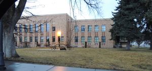
 Stevens County Courthouse in Colville | |
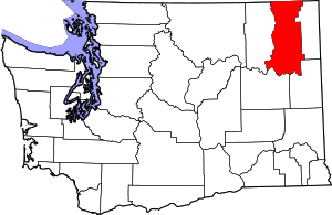
 Location within the U.S. state of واشنطن | |
 موقع Washington ضمن الولايات المتحدة | |
| الإحداثيات: Coordinates: 48°24′N 117°51′W / 48.40°N 117.85°W | |
| البلد | |
| State | |
| تأسست | يناير 20, 1863 |
| السمِيْ | آيزاك ستيڤنز |
| Seat | كولڤل |
| Largest city | كولڤل |
| المساحة | |
| • الإجمالي | 2٬541 ميل² (6٬580 كم²) |
| • البر | 2٬478 ميل² (6٬420 كم²) |
| • الماء | 63 ميل² (160 كم²) 2.5%% |
| التعداد | |
| • Estimate (2013) | 43٬430 |
| • الكثافة | 17/sq mi (6٫7/km2) |
| Congressional district | 5th |
| الموقع الإلكتروني | www |
مقاطعة ستيڤنز إنگليزية: Stevens County هي إحدى مقاطعات ولاية واشنطون في الولايات المتحدة الأمريكية. مقاطعة ستيڤنز هي جزء من المنطقة الإحصائية العمرانية سپوكين-وادي سپوكين، واشنطن.
. . . . . . . . . . . . . . . . . . . . . . . . . . . . . . . . . . . . . . . . . . . . . . . . . . . . . . . . . . . . . . . . . . . . . . . . . . . . . . . . . . . . . . . . . . . . . . . . . . . . . . . . . . . . . . . . . . . . . . . . . . . . . . . . . . . . . . . . . . . . . . . . . . . . . . . . . . . . . . . . . . . . . . . .
المقاطعات المجاورة
- Pend Oreille County, Washington - east
- Spokane County, Washington - southeast
- Lincoln County, Washington - southwest
- Ferry County, Washington - west
- Kootenay Boundary Regional District, British Columbia - northeast
- Regional District of Central Kootenay, British Columbia - north
المناطق المحمية الوطنية
- Pacific Northwest National Scenic Trail (part)
- Colville National Forest (part)
- Kaniksu National Forest (part)
- Lake Roosevelt National Recreation Area (part)
- Little Pend Oreille National Wildlife Refuge (part)
الديمغرافيا
| التعداد تاريخياً | |||
|---|---|---|---|
| الإحصاء | التعداد | %± | |
| 1860 | 996 | ||
| 1870 | 734 | -26.3% | |
| 1880 | 1٬245 | 69.6% | |
| 1890 | 4٬341 | 248.7% | |
| 1900 | 10٬543 | 142.9% | |
| 1910 | 25٬297 | 139.9% | |
| 1920 | 21٬605 | -14.6% | |
| 1930 | 18٬550 | -14.1% | |
| 1940 | 19٬275 | 3.9% | |
| 1950 | 18٬580 | -3.6% | |
| 1960 | 17٬884 | -3.7% | |
| 1970 | 17٬405 | -2.7% | |
| 1980 | 28٬979 | 66.5% | |
| 1990 | 30٬948 | 6.8% | |
| 2000 | 40٬066 | 29.5% | |
| 2010 | 43٬531 | 8.6% | |
| تقديري 2013 | 43٬430 | 8.4% | |
1790-1960[2] 1900-1990[3] 1990-2000[4] 2010-2013[5] | |||
التجمعات السكنية
المدن والبلدات
- 4,675 - Colville
- 2,606 - Chewelah
- 1,597 - Kettle Falls
- 292 - Northport
- 280 - Springdale
- 183 - Marcus
2012 Estimate population[6]
أماكن موسومة بالإحصاء
تجمعات أخرى
السياسة
| Year | Republican | Democratic | Third parties |
|---|---|---|---|
| 2016 | 64.8% 15,161 | 24.7% 5,767 | 10.5% 2,467 |
| 2012 | 60.9% 13,691 | 34.5% 7,762 | 4.7% 1,047 |
| 2008 | 58.1% 13,132 | 37.6% 8,499 | 4.3% 960 |
| 2004 | 64.0% 13,015 | 33.5% 6,822 | 2.5% 503 |
| 2000 | 62.8% 11,299 | 30.9% 5,560 | 6.3% 1,140 |
| 1996 | 47.0% 7,524 | 34.9% 5,591 | 18.1% 2,907 |
| 1992 | 38.6% 5,706 | 33.5% 4,960 | 27.9% 4,121 |
| 1988 | 55.0% 6,576 | 42.4% 5,068 | 2.7% 318 |
| 1984 | 64.3% 8,211 | 33.7% 4,304 | 2.0% 256 |
| 1980 | 61.5% 7,094 | 31.1% 3,584 | 7.4% 852 |
| 1976 | 51.8% 4,719 | 42.0% 3,824 | 6.2% 566 |
| 1972 | 61.3% 4,839 | 30.3% 2,390 | 8.5% 670 |
| 1968 | 46.8% 3,435 | 40.1% 2,948 | 13.1% 962 |
| 1964 | 43.6% 3,302 | 56.3% 4,266 | 0.1% 10 |
| 1960 | 51.2% 4,076 | 48.5% 3,861 | 0.2% 18 |
| 1956 | 54.1% 4,499 | 45.8% 3,808 | 0.2% 15 |
| 1952 | 56.5% 4,458 | 42.6% 3,355 | 0.9% 72 |
| 1948 | 40.1% 2,977 | 56.6% 4,205 | 3.4% 252 |
| 1944 | 44.0% 3,151 | 55.1% 3,951 | 0.9% 63 |
| 1940 | 39.5% 3,238 | 59.8% 4,904 | 0.8% 66 |
| 1936 | 28.6% 1,981 | 65.4% 4,536 | 6.0% 418 |
| 1932 | 32.1% 2,247 | 60.9% 4,262 | 6.9% 485 |
| 1928 | 63.1% 3,813 | 35.5% 2,147 | 1.5% 88 |
| 1924 | 48.9% 2,909 | 11.5% 685 | 39.5% 2,350 |
| 1920 | 55.7% 3,282 | 24.6% 1,452 | 19.7% 1,160 |
| 1916 | 40.3% 2,684 | 47.8% 3,184 | 11.8% 788 |
| 1912 | 13.5% 810 | 33.0% 1,979 | 53.5% 3,212[8] |
| 1908 | 52.1% 2,546 | 32.0% 1,564 | 15.9% 774 |
| 1904 | 63.3% 2,369 | 23.3% 872 | 13.4% 501 |
| 1900 | 40.0% 1,121 | 57.5% 1,612 | 2.6% 73 |
| 1896 | 18.1% 433 | 80.4% 1,926 | 1.5% 36 |
| 1892 | 37.3% 622 | 30.1% 501 | 32.6% 544 |
. . . . . . . . . . . . . . . . . . . . . . . . . . . . . . . . . . . . . . . . . . . . . . . . . . . . . . . . . . . . . . . . . . . . . . . . . . . . . . . . . . . . . . . . . . . . . . . . . . . . . . . . . . . . . . . . . . . . . . . . . . . . . . . . . . . . . . . . . . . . . . . . . . . . . . . . . . . . . . . . . . . . . . . .
انظر أيضاً
الهامش
- ^ "U.S. Decennial Census". United States Census Bureau. Retrieved January 7, 2014.
- ^ "Historical Census Browser". University of Virginia Library. Retrieved January 7, 2014.
- ^ "Population of Counties by Decennial Census: 1900 to 1990". United States Census Bureau. Retrieved January 7, 2014.
- ^ "Census 2000 PHC-T-4. Ranking Tables for Counties: 1990 and 2000" (PDF). United States Census Bureau. Retrieved January 7, 2014.
- ^ خطأ استشهاد: وسم
<ref>غير صحيح؛ لا نص تم توفيره للمراجع المسماةQF - ^ "Incorporated Places and Minor Civil Divisions: Washington". Population Census. United States Census Bureau. 2013-09-26. Retrieved 2013-09-26.
- ^ Leip, David. "Dave Leip's Atlas of U.S. Presidential Elections". uselectionatlas.org. Retrieved April 10, 2018.
- ^ The leading "other" candidate, Progressive Theodore Roosevelt, received 1,971 votes, while Socialist candidate Eugene Debs received 988 votes, Prohibition candidate Eugene Chafin received 227 votes, and Socialist Labor candidate Arthur Reimer received 26 votes.
للاستزادة
- An illustrated history of Stevens, Ferry, Okanogan and Chelan counties, State of Washington. Western Historical Pub. Co. 1904.Available online through the Washington State Library's Classics in Washington History collection
وصلات خارجية
- Stevens County, Washington Government Page
- The Stevens County Wiki Project: A community wiki project, dedicated to creating an online wiki guide to Stevens County, Washington. Powered by Media Wiki.
- Stevens County Rural Library District: hosts of the Stevens County Wiki Project, the Stevens County Library District (SCRLD) has various regional links available from their website.
- Stevens County Heritage Historical photos and documents from the Libraries of Stevens County.
- uppercolumbia.net: a regional portal site for Stevens County and beyond. Includes business links and events calendar.
- The Heritage Network: History and Genealogy Resources for the Upper Columbia Region.
- An 1884 hailstorm in Stevens County on Wikisource
- Crossroads on the Columbia Preserve America Project Interpretive Section
- Crossroads on the Columbia Preserve America Project collection, exhibits, and images from museum and private collections covering Stevens County
- Short description is different from Wikidata
- Coordinates on Wikidata
- Infobox U.S. county using a non-standard timezone
- Washington (state) counties
- Articles containing إنگليزية-language text
- Pages using div col with unknown parameters
- مقاطعات ولاية واشنطن الأمريكية
- مقاطعة ستيڤنز، واشنطن
- أماكن مأهولة تأسست في 1863
- تأسيسات 1863 في الولايات المتحدة
- واشنطن الشرقية
