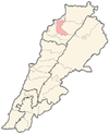
سرعل
Sereel
سرعل | |
|---|---|
City | |
| الإحداثيات: 34°17′24″N 35°54′41″E / 34.29000°N 35.91139°ECoordinates: 34°17′24″N 35°54′41″E / 34.29000°N 35.91139°E | |
| Country | |
| Governorate | North Governorate |
| District | Zgharta District |
| المنسوب | 521 m (1٬709 ft) |
| منطقة التوقيت | UTC+2 (EET) |
| • الصيف (التوقيت الصيفي) | UTC+3 (EEST) |
| Dialing code | +961 |
سرعل هي احدى القرى اللبنانية من قرى قضاء زغرتا في محافظة الشمال.
. . . . . . . . . . . . . . . . . . . . . . . . . . . . . . . . . . . . . . . . . . . . . . . . . . . . . . . . . . . . . . . . . . . . . . . . . . . . . . . . . . . . . . . . . . . . . . . . . . . . . . . . . . . . . . . . . . . . . . . . . . . . . . . . . . . . . . . . . . . . . . . . . . . . . . . . . . . . . . . . . . . . . . . .
المراجع
| هل أنت مهتم ببلد الأرز لبنان ؟ ستجد الكثير من المعلومات عنه في بوابة لبنان. |
الكلمات الدالة:

