خط الطول 180


خط الطول 180 أو خط الزوال المقابل antimeridian[1] is the meridian 180° both east and west of the Prime Meridian, with which it forms a great circle dividing the earth into the نصفي الكرة الغربي والشرقي. It is common to both east longitude and west longitude. It mostly passes through the open waters of the Pacific Ocean, but passes across land in Russia, Fiji and Antarctica. This meridian is used as the basis for the International Date Line, but the latter deviates from it to maintain date consistency within the territories of Russia, USA, Kiribati, Fiji and New Zealand.
Starting at the North Pole and heading south to the South Pole, the 180th meridian passes through:

The meridian also passes between (but not particularly close to):
- the Gilbert Islands and the Phoenix Islands of Kiribati
- North Island and the Kermadec Islands of نيوزيلندا
- جزر باونتي و جزر تشاتم، أيضاً تابعين لنيوزيلندا
The only place where roads cross this meridian, and where there are buildings very close to it, is in Fiji.
. . . . . . . . . . . . . . . . . . . . . . . . . . . . . . . . . . . . . . . . . . . . . . . . . . . . . . . . . . . . . . . . . . . . . . . . . . . . . . . . . . . . . . . . . . . . . . . . . . . . . . . . . . . . . . . . . . . . . . . . . . . . . . . . . . . . . . . . . . . . . . . . . . . . . . . . . . . . . . . . . . . . . . . .
مشاكل تمثيل البرمجيات
Many geographic software libraries or data formats project the world to a rectangle; very often this rectangle is split exactly at the 180th meridian. This often makes it non-trivial to do simple tasks (like representing an area, or a line) over the 180th meridian. Some examples:
- The GeoJSON specification strongly suggests splitting geometries so that neither of their parts cross the antimeridian.[2]
- In OpenStreetMap, areas (like the boundary of Russia) are split at the 180th meridian.
انظر أيضاً
الهامش
- ^ The word antimeridian can also mean the meridian opposite to any given meridian. E.g. 20° غرب is the antimeridian of 160° شرق.
- ^ "RFC 7946 - The GeoJSON Format".

قياس ومواصفات الزمن | ||
|---|---|---|
| المواضيع الرئيسية |  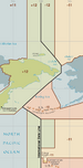 | |
| المواصفات العالمية | ||
| مواصفات لاغية | ||
| الزمن في الفيزياء | ||
| Horology | ||
| التقويم | ||
| علم الآثار والجيولوجيا | ||
| كرونولوجيا فلكية | ||
| وحدات غير معتادة | ||
| مواضيع متعلقة | ||