جزيرة نپيان (جزيرة نورفوك)
الاسم الأصلي: Nepeyan Ailen | |
|---|---|
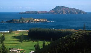
 View across to Nepean Island (foreground) and Phillip Island in the distance | |
 | |
| الجغرافيا | |
| الموقع | Pacific Ocean |
| الإحداثيات | 29°4′16″S 167°57′50″E / 29.07111°S 167.96389°ECoordinates: 29°4′16″S 167°57′50″E / 29.07111°S 167.96389°E |
| المساحة | 10 ha (25 acres) |
| الإدارة | |
| السكان | |
| التعداد | 0 |
| معلومات إضافية | |
| Time zone |
|
جزيرة نپيان ( Nepean Island ؛ نورفوك: Nepeyan Ailen) هي جزيرة صغيرة غير مأهولة تقع على بعد 800 metres (870 yards) جنوب جزيرة نورفوك في جنوب غرب المحيط الهادي. الجزيرة تبلغ مساحتها نحو 10 hectares (25 acres).[1] Nepean Island is uninhabited due to its small size and tall cliffs flanking it, making landfall nearly impossible for small boats. It is part of the Commonwealth of Australia's external territory of Norfolk Island, and is included in the Norfolk Island National Park as is nearby Phillip Island and about 10 percent of Norfolk Island proper.
. . . . . . . . . . . . . . . . . . . . . . . . . . . . . . . . . . . . . . . . . . . . . . . . . . . . . . . . . . . . . . . . . . . . . . . . . . . . . . . . . . . . . . . . . . . . . . . . . . . . . . . . . . . . . . . . . . . . . . . . . . . . . . . . . . . . . . . . . . . . . . . . . . . . . . . . . . . . . . . . . . . . . . . .
التاريخ
Unlike Norfolk and Phillip Islands, Nepean is not volcanic in origin, but is Late Pleistocene limestone formed from wind blown sand dunes between the last two ice ages. Calcareous sand grains were bound by carbonate cement to form a calcarenite limestone.[2][1]
Although Polynesian people were known to have settled around Kingston, no evidence of Polynesian settlement has been found on Nepean Island. The island was first cleared during the First Settlement.[1] Nepean was used as a quarry and for timber during the Second Convict Settlement of Norfolk Island, and was abandoned as a site during that settlement.[1] Remaining stone steps can be seen on the east coast.[1]
It is thought the island was named in 1788 by Lieutenant Philip Gidley King for Evan Nepean, Under-Secretary of State for the Home Department, who was involved with arrangements for the dispatch of the First Fleet and with administration of the colony of New South Wales during its early years.[3][1]
النبيت والوحيش
The island is made of calcareous rock dating from the late Pleistocene and is a breeding site for several species of seabirds.[1] Before being cleared in the 1790s, the island was home to about 200 Norfolk Island Pines. Today, native plants present on the island include pigface, native spinach, moo-oo, native flax and native rush.[1] The masked booby breeds onsite during the summer. From July to December little shearwaters breed on the island. Other birds such as the whale bird, grey noddy, black noddy, wedge-tailed shearwater, brown noddy and red-tailed tropicbird also breed on Nepean Island. It is a refuge for the endemic marbled gecko, which is now extinct on Norfolk Island. It is also home to the Phillip Island skink.[1] The island is home to little nipper landcrabs and freshwater crabs. Green turtles are often seen off the coast of the island.[1]
انظر أيضاً
المراجع
- ^ أ ب ت ث ج ح خ د ذ ر "Government Datasheet, Nepean" (PDF). Archived from the original (PDF) on 2016-03-04. Retrieved 2020-04-16.
- ^ Pees, S.T.; Duvall, G.C.; Girault, J.P. (2003). "Eolian calcarenite and heavy minerals from the southwest Pacific". Carbonates and Evaporites. 18 (2): 108–119. doi:10.1007/BF03176232. S2CID 129464514.
- ^ Parsons, Vivienne (1967). "Nepean, Nicholas (1757–1823)". In Pike, Douglas Henry (ed.). Australian Dictionary of Biography. Carlton, Victoria: Melbourbe University Press. Retrieved 31 August 2020.
