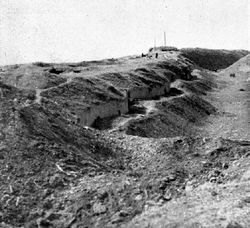
برزخ پركوپ
برزخ پركوپ (أوكرانية: Перекопський перешийок؛ الرومنة: Perekops'kyy pereshyyok؛ روسية: Перекопский перешеек؛ الرومنة: Perekopskiy peresheek Crimean Tatar: Or boynu؛ تركية: Orkapı؛ باليونانية: Τάφρος؛ الرومنة: Taphros؛ إنگليزية: Isthmus of Perekop) هو لسان أرضي ضيق بعرض 5–7 كيلومتر يربط شبه جزيرة القرم بالبر الرئيسي لأوكرانيا. ويمتد البرزخ بين البحر الأسود إلى الغرب و سيڤاش إلى الشرق. ويأخذ البرزخ اسمه "پركوپ" من حصن التتار أور قپي.
الحدود بين جمهورية القرم وأوبلاست خرسون الأوكراني تجري في الجزء الشمالي للبرزخ. مدن پركوپ وأرميانسك, ru (Suvorovo (Crimea)) و كراسنوپركوپسك تقع جميعاً في البرزخ. وتجري قناة القرم الشمالية عبر البرزخ، لتزوّد القرم بالماء العذب من نهر دنيپر. وقد أغلقت أوكرانيا القناة في 2014، وتم استبدال الإمداد بالمياه بمصادر محلية وروسية.
جنوب پركوپ توجد خامات ثرية من الملح، لها أهمية تجارية للمنطقة.
. . . . . . . . . . . . . . . . . . . . . . . . . . . . . . . . . . . . . . . . . . . . . . . . . . . . . . . . . . . . . . . . . . . . . . . . . . . . . . . . . . . . . . . . . . . . . . . . . . . . . . . . . . . . . . . . . . . . . . . . . . . . . . . . . . . . . . . . . . . . . . . . . . . . . . . . . . . . . . . . . . . . . . . .
التاريخ
The strategic and commercial value of this area, together with the strategic value of being the gateway to Crimea, has made the isthmus the location of some particularly fierce battles. From antiquity through the Byzantine era the Greeks fortified the area, and so subsequently did the تتار القرم. In the 15th century the area became a colony of the maritime جمهورية جنوة. وفي 1783 أصبحت المنطقة جزءاً من الامبراطورية الروسية، التي جعلت پركوپ a county center of Tavriia gubernia.[1][2] In 1954, together with Crimea it was transferred to the Ukrainian Soviet Republic.
في نوفمبر 1920، أثناء الحرب الأهلية الروسية، نشبت معركة هنا بين الجيش الأحمر والقوات البيضاء بقيادة پيوتر ڤرانگل، الذي كان مسيطراً على القرم. وقد انتصر فيها الجيش الأحمر، إلا أن 140,000 مدنياً فروا عبر البحر الأسود إلى اسطنبول.
أثناء الحرب العالمية الثانية، the combined forces of German and Romanian troops under the command of Erich von Manstein دخلت القرم عبر برزخ پركوپ. The battle of the isthmus lasted five days from September 24, 1941 before the isthmus was secured by the Axis forces. On October 27 the Axis forces advanced further into Crimea, leading to the Battle of Sevastopol. On 9 May 1944, the Red Army regained control of Crimea (هجوم القرم (8 أبريل – 12 مايو 1944)).
وفي 2 مارس 2014، أفيد أن قوات روسية تحفر خنادق بطول الحدود بين القرم وأوكرانيا، والتي تمتد عبر البرزخ، بطول خندق التتار القديم.[3]
المراجع
- ^ Danylo Husar Struk (15 December 1993). Encyclopedia of Ukraine: Volume III: L-Pf. University of Toronto Press, Scholarly Publishing Division. p. 2488. ISBN 978-1-4426-5125-8.
- ^ J. Murray. Handbook for Travellers in Russia, Poland, and Finland. Рипол Классик. p. 277. ISBN 978-1-147-56625-3.
- ^ "Ukraine orders full military mobilisation over Russia moves". BBC News. Retrieved March 2, 2014.
Coordinates: 46°08′58″N 33°40′20″E / 46.14944°N 33.67222°E


