بردجتاون
مدينة بردجتاون
بردجتاون | |
|---|---|
 جسر شامبرلين يمتد من كاريندج، بردجتاون. | |
 Seal | |
 موقع بردجتاون (النجمة الحمراء) | |
 مدينة بردجتاون موقع بردجتاون في باربادوس. | |
| الإحداثيات: 13°06′21″N 59°36′47″W / 13.10583°N 59.61306°WCoordinates: 13°06′21″N 59°36′47″W / 13.10583°N 59.61306°W[1] | |
| البلد | باربادوس |
| الأبرشية | سان مايكل |
| تأسست | 1628 |
| المساحة | |
| • الإجمالي | 15 ميل² (40 كم²) |
| المنسوب | 3 ft (1 m) |
| التعداد (2014) | |
| • الإجمالي | 110٬000 |
| • الكثافة | 7٬300/sq mi (2٬800/km2) |
| منطقة التوقيت | UTC-4 (Eastern Caribbean Time Zone) |
| مفتاح الهاتف | +1 246 |
| الاسم الرسمي | بردجتاون التاريخية وحاميتها |
| النوع | ثقافي |
| المعيار | ii, iii, vi |
| التوصيف | 2011 |
| الرقم المرجعي | 1376 |
| الدولة | باربادوس |
| المنطقة | الأمريكتين |
بردجتاون (UN/LOCODE: BB BGI)[3] هي عاصمة وأكبر مدن باربادوس. بلدة سانت مايكل، السابقة، منطقة بردجتاون الكبرى تقع في أبرشية سانت مايكل. أحياناً ما يشار لبردجتاون محلياً باسم "المدينة"، لكن الإشارة الأكثر شيوعاً هي "البلدة". في 2014، كان عدد سكان منطقة بردجتاون الكبرى 110.000 نسمة.
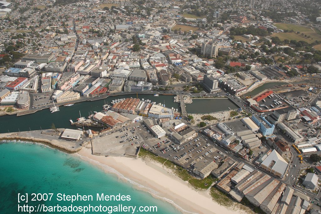
ميناء بردجتاون، الذي يقع على امتداد خليج كارليسل (عند 13°06′22″N 59°37′55″W / 13.106°N 59.632°W) يطل على الساحل الجنوبي الغربي للجزيرة. مناطق بردجتاون الكبرى[4] تقع بالقرب من حدود أبراشية كريست تشرش وسانت جيمش المجاورة، وعلى بعد 16 كم جنوب شرق مركز مدينة بردجتاون، وتسافر منها رحلات يومية إلى المدن الكبرى في المملكة المتحدة، الولايات المتحدة، كندا والكاريبي. في الوقت الذي لا توجد فيه حكومة بلدية محلية، تقع المدينة تحت حكم دائرة سياسية تابعة للبرلمان الوطني. في عهد فدرالية أراضي الهند الغربية البريطانية التي استمرت لفترة قصيرة، عقد 1950-عقد 1960، كانت بردجتاون واحدة من المدن العواصم الثلاثة[5] للمنطقة حيث كانت تعتبر عاصمة فدرالية للمنطقة.[6][7]
تأسس الموقع الحالي للمدينة من قبل المستوطنين الإنگليز عام 1628 بعد إقامة أول مستوطنة في إطار سلطة السير وليام كورتن في هولتاون، سانت جيمس تاون. بردجتاون هي وجهة سياحية هامة في جزر الهند الغربية، وتعتبر المدينة مركزاً مالياً، معلوماتياً، واقتصادياً هاماً، كما تعتبر ميناء استعداء]] لسفن الرحلات في منطقة الكاريبي. في 25 يونيو 2011، أدرجت بردجتاون التاريخية وحاميتها على قائمة اليونسكو لمواقع التراث العالمي.[8][9][10]
. . . . . . . . . . . . . . . . . . . . . . . . . . . . . . . . . . . . . . . . . . . . . . . . . . . . . . . . . . . . . . . . . . . . . . . . . . . . . . . . . . . . . . . . . . . . . . . . . . . . . . . . . . . . . . . . . . . . . . . . . . . . . . . . . . . . . . . . . . . . . . . . . . . . . . . . . . . . . . . . . . . . . . . .
التاريخ
الاستيطان المبكر


من بلدة لمدينة

الجغرافيا والمناخ
الجغرافيا

الحدود
الكاريناج
المناخ
| بيانات مناخ بردجتاون (مطار گرانتلي أدم الدولي) 1981–2010، درجات الحرارة 1944–الحاضر | |||||||||||||
|---|---|---|---|---|---|---|---|---|---|---|---|---|---|
| الشهر | يناير | فبراير | مارس | أبريل | مايو | يونيو | يوليو | أغسطس | سبتمبر | اكتوبر | نوفمبر | ديسمبر | العام |
| العظمى القياسية °س (°ف) | 32.0 (89.6) |
31.2 (88.2) |
31.9 (89.4) |
32.6 (90.7) |
33.1 (91.6) |
32.7 (90.9) |
32.4 (90.3) |
35.0 (95) |
33.3 (91.9) |
33.3 (91.9) |
33.3 (91.9) |
31.3 (88.3) |
35٫0 (95) |
| العظمى المتوسطة °س (°ف) | 28.8 (83.8) |
29.0 (84.2) |
29.5 (85.1) |
30.0 (86) |
30.5 (86.9) |
30.5 (86.9) |
30.4 (86.7) |
30.6 (87.1) |
30.6 (87.1) |
30.4 (86.7) |
30.0 (86) |
29.3 (84.7) |
30٫0 (86) |
| المتوسط اليومي °س (°ف) | 25.8 (78.4) |
25.7 (78.3) |
26.2 (79.2) |
26.8 (80.2) |
27.6 (81.7) |
27.7 (81.9) |
27.6 (81.7) |
27.8 (82) |
27.7 (81.9) |
27.5 (81.5) |
27.0 (80.6) |
26.4 (79.5) |
27٫0 (80٫6) |
| الصغرى المتوسطة °س (°ف) | 22.9 (73.2) |
22.8 (73) |
23.2 (73.8) |
24.1 (75.4) |
24.9 (76.8) |
25.1 (77.2) |
24.9 (76.8) |
24.7 (76.5) |
24.6 (76.3) |
24.5 (76.1) |
24.2 (75.6) |
23.6 (74.5) |
24٫1 (75٫4) |
| الصغرى القياسية °س (°ف) | 16.0 (60.8) |
16.0 (60.8) |
16.0 (60.8) |
19.0 (66.2) |
19.4 (66.9) |
20.0 (68) |
19.3 (66.7) |
19.1 (66.4) |
20.6 (69.1) |
20.6 (69.1) |
18.0 (64.4) |
17.4 (63.3) |
16٫0 (60٫8) |
| سقوط الأمطار mm (inches) | 70.1 (2.76) |
41.3 (1.626) |
37.4 (1.472) |
60.8 (2.394) |
79.0 (3.11) |
103.0 (4.055) |
132.9 (5.232) |
141.9 (5.587) |
157.6 (6.205) |
185.1 (7.287) |
171.6 (6.756) |
89.6 (3.528) |
1٬270٫3 (50٫012) |
| % Humidity | 77 | 77 | 75 | 77 | 78 | 80 | 81 | 81 | 81 | 82 | 83 | 79 | 79 |
| Avg. rainy days | 11 | 8 | 8 | 8 | 8 | 11 | 15 | 15 | 14 | 16 | 14 | 12 | 140 |
| Sunshine hours | 258.85 | 249.45 | 272.80 | 259.80 | 262.88 | 225.00 | 251.41 | 263.19 | 230.40 | 233.74 | 228.00 | 257.92 | 2٬993٫44 |
| Source #1: خدمة الأرصاد الجوية في باربادوس[11] | |||||||||||||
| Source #2: Meteo Climat (record highs and lows)[12] | |||||||||||||
. . . . . . . . . . . . . . . . . . . . . . . . . . . . . . . . . . . . . . . . . . . . . . . . . . . . . . . . . . . . . . . . . . . . . . . . . . . . . . . . . . . . . . . . . . . . . . . . . . . . . . . . . . . . . . . . . . . . . . . . . . . . . . . . . . . . . . . . . . . . . . . . . . . . . . . . . . . . . . . . . . . . . . . .
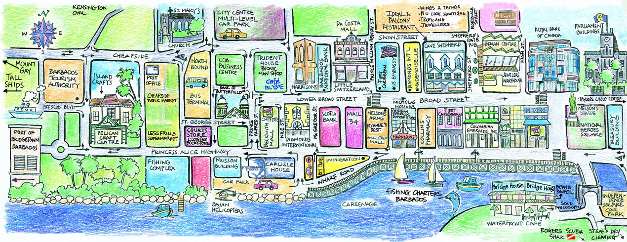
المدينة


الضواحي
المعالم الرئيسية
- ميدان الأبطال الوطني (ميدان الطرف الأغر سابقاً) وحديقة النافورة [13]


- ميدان الاستقلال وقوس الاستقلال
- نافورة مونتيفوار
- مبنى برلمان باربادوس
- كنيسة كاتدرائية القديس مايكل وجميع الملائكة
- كنيسة القديسة ماري الأنگليكانية
- كنيسة القديس پاتريك للروم الكاثوليك
- الكنيس اليهودي
- پليكان ڤيلدج وكرافت سنتر
- كوينز پارك
- تمثال اللورد نلسون
- متحف باربادوس
- كنسينگتون أوڤال (موقع نهائي كأس العالم للكريكت 2007)
- شاطئ خليج كارليسل
- سوق شيپسايد
- مجمع توم آدمز التجاري
- قاعدة فرانك كوليمور للفنون التطبيقية
- قصر الكاتدرائية
الميناء

المجتمع والثقافة


المرافق والخدمات المحلية

الاقتصاد
النقل
. . . . . . . . . . . . . . . . . . . . . . . . . . . . . . . . . . . . . . . . . . . . . . . . . . . . . . . . . . . . . . . . . . . . . . . . . . . . . . . . . . . . . . . . . . . . . . . . . . . . . . . . . . . . . . . . . . . . . . . . . . . . . . . . . . . . . . . . . . . . . . . . . . . . . . . . . . . . . . . . . . . . . . . .
المدن الشقيقة
بردجتاون على توأمة مع المدن التالية:
 – بردجتاون، نوڤا سكوشيا، كندا (9 يوليو 2004)[14]
 – ضاحية هاكني، لندن، إنگلترة
 – ويلمينگتون، كارولينا الشمالية، الولايات المتحدة (28 يونيو 2004)
مشاهير المدينة
- ريحانة، مغنية وكاتبة أغاني
- أورلاندو گرين، عداء أولمپي [15]
- ريتشارد كلمنت مودي، مؤسس [[كولومبيا البريطانيةي]
- جاكي أوپل، ينسب له إنشاء نوع من الموسيقى التجريبية تسمى سپودج
انظر أيضاً
- ديموغرافيا باربادوس
- قائمة مدن باربادوس
- قائمة مدن الكاريبي
- قائمة المناطق الكبرى في جزر الهند الغربية
- أبراشيات باربادوس
- النقل في باربادوس
المصادر
- ^ "Bridgetown, Barbados". Google Maps. Retrieved 20 August 2011.
- ^ "Population of Bridgetown, Barbados". Population.mongabay.com. 2012-01-18. Retrieved 2012-07-24.
- ^ Barbados codes, United Nations - Code for Trade and Transport Locations (UN/LOCODE) via UNECE
- ^ "Restore priority of B'town Redevelopment Plan". The Barbados Advocate. 21 March 2012. Retrieved 14 April 2012.
{{cite news}}: Cite has empty unknown parameter:|deadurl=(help) - ^ Nantambu, Dr. Kwame (12 December 2005). "W.I. Federation: Failure From the Start". Trinicenter.com. Retrieved 1 September 2012.
{{cite web}}: Cite has empty unknown parameters:|deadurl=and|separator=(help) - ^ Kasperson, Roger E.; Minghi, Julian V. (2011). "Decision Making". The Structure of Political Geography. New Brunswick, NJ: Transaction Publishers. pp. Pgs. 350–365. ISBN 978-1-4128-1854-4. LCCN 2011003509.
{{cite book}}:|pages=has extra text (help); Cite has empty unknown parameters:|month=and|chapterurl=(help) - ^ Lewis, Gordon K. The Growth of the Modern West Indies. pp. Pgs. 350–365. ISBN 976-637-171-7.
{{cite book}}:|pages=has extra text (help); Cite has empty unknown parameters:|month=and|chapterurl=(help) - ^ "Barbados enters World Heritage List with Bridgetown and its Garrison; Hiraizumi (Japan) and Germany's Beech Forests also inscribed". UNESCOPRESS. UNESCO. 25 June 2011. Retrieved 26 June 2011.
The World Heritage Committee has inscribed three new sites on UNESCO's World Heritage List so far today: the Ancient Beech Forests of Germany as an extension to the World Heritage site of Primeval Beech Forests of the Carpathians (Slovakia, Ukraine), Historic Bridgetown and its Garrison, the first heritage site of Barbados to enter the World Heritage List; and Hiraizumi – Temples, Gardens and Archaeological Sites
{{cite web}}: Cite has empty unknown parameters:|deadurl=,|doibroken=,|separator=, and|embargo=(help) - ^ Ramsay, Allison (26 June 2011). "Barbados makes the list!". The Barbados Advocate. Retrieved 26 June 10``.
Historic Bridgetown and its Garrison site was considered for nomination after Barbados became signatory to the UNESCO Convention for the Protection of World Cultural and Natural Heritage Convention in 2002. Barbados submitted the nomination dossier to UNESCO World Heritage Centre on February 1, 2009, and that was among 45 proposals which were examined by the World Heritage Committee in June 2010. A total of 35 nominations including natural, cultural and mixed properties are being reviewed by the Committee. The session will end on 29 June.
{{cite news}}: Check date values in:|accessdate=(help); Cite has empty unknown parameters:|pmd=and|deadurl=(help) - ^ "Historic Bridgetown now a World Heritage Site". Caribbean Broadcasting Corporation (CBC). 26 June 2011. Retrieved 26 June 2011.
The World Heritage Committee, meeting in Paris, said Bridgetown and its garrison deserved a place on the List, which is comprised of [ك] more than 900 cultural or natural sites around the world regarded as having outstanding universal value.
{{cite news}}: Cite has empty unknown parameters:|pmd=and|deadurl=(help) - ^ "Barbados Weather Climate Data". Barbados Meteorological Services. Retrieved 6 November 2016.
- ^
"Station Grantley" (in French). Meteo Climat. Retrieved 6 November 2016.
{{cite web}}: CS1 maint: unrecognized language (link) - ^ Trafalgar Square
- ^ Miller, Dame Billie (2004-07-09). "Remarks by Senior Minister Dame Billie Miller at the Signing Ceremony on the Occasion of the Twinning of Bridgetown, Nova Scotia and Bridgetown, Barbados" (PDF). Foreign.gov.bb. Ministry of Foreign Affairs, Foreign Trade and International Business (Barbados). Bridgetown, N.S., Canada. Retrieved 2017-01-19.
{{cite web}}: Cite has empty unknown parameter:|dead-url=(help) - ^ Fox, Scarlett (22 October 2012). "Newsome Coach Orlando Greene: From Caribbean To Olympian". Retrieved 24 March 2016.
وصلات خارجية
- World Heritage Sites in Barbados, UNESCO
- Deep Water Harbour Port
- Bridgetown Cruise Terminals
- Map overview of Bridgetown
- Aerial view over Bridgetown's centre
- Detailed map of Bridgetown
- Map showing area designated as Historic Bridgetown and the Garrison, UNESCO
- The Tramways of Bridgetown, Barbados
- The Importance of Bridgetown in the New world – The UNESCO World Heritage Centre website
- Historic Bridgetown and Its Garrison على فيسبوك
- CS1 errors: extra text: pages
- Articles with hatnote templates targeting a nonexistent page
- Short description is different from Wikidata
- Coordinates on Wikidata
- بردجتاون
- أماكن مأهولة في باربادوس
- أماكن ساحلية مأهولة في باربادوس
- عواصم في الكاريبي
- عواصم في أمريكا الشمالية
- أماكن مأهولة تاسست في القرن 17
- تأسيسات 1628 في الامبراطورية البريطانية
- أماكن مأهولة تأسست في 1628
- مدن موانئ في الكاريبي
- مواقع التراث العالمي في باربادوس