الهرسك
الهرسك
Hercegovina / Херцеговина Herzegovina | |
|---|---|
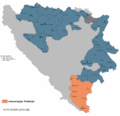
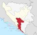
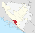
 المنطقة التقريبية للهرسك ضمن البوسنة والهرسك | |
| الإحداثيات: 43°28′37″N 17°48′54″E / 43.47694°N 17.81500°E | |
| البلد | البوسنة والهرسك |
| أكبر المدن | موستار تربينيى |
| المساحة | |
| • الإجمالي | 11٬000 كم² (4٬000 ميل²) |
| التعداد (1991) | |
| • الإجمالي | 466٬284 |
| • الكثافة | 42/km2 (110/sq mi) |
| • % الإجمالية من البوسنة والهرسك | 10٫65% |
| • الجماعات العرقية | الكروات 47٫74%بوشناق 26٫07%الصرب 20٫51% |
| صفة المواطن | Herzegovinian |
| منطقة التوقيت | UTC+1 (CET) |
| • الصيف (التوقيت الصيفي) | CEST |
الهرسك (Herzegovina ؛ /ˌhɛərtsᵻˈɡoʊvᵻnə/؛ HAIRT-sə-GOH-vi-nə أو /ˌhɜːrtsəɡoʊˈviːnə/؛[1] البوسنية والكرواتية والصربية: Hercegovina, Херцеговина, [xɛ̌rtsɛɡov̞ina]) هي منطقة جنوبية في البوسنة والهرسك. وبينما لا توجد حدود رسمية تفصلها عن منطقة البوسنة، فالمتعارف هو أن حدود المنطقة هي كرواتيا إلى الجنوب الغربي، والجبل الأسود إلى الشرق، و جبل ماگليچ إلى الشمال الشرقي، و جبل إيڤان إلى الشمال.[بحاجة لمصدر] مساحة المنطقة تتراوح من 11,419 كم²،[2] أي نحو 22% من المساحة الإجمالية لدولة البوسنة والهرسك الحالية،[3] إلى 12,276 كم²، أي نحو 24% من البلد.[4]
الاسم "الهرسك Herzegovina" يعني "أرض الدوق"، ويشير إلى دوقية ستيپان ڤوكوچيچ كوساچا الذي حصل على لقب هرسگ Herceg القديس ساڤا. هرسگ مشتقة من اللقب الألماني هرتسوگ Herzog.[5][6]
. . . . . . . . . . . . . . . . . . . . . . . . . . . . . . . . . . . . . . . . . . . . . . . . . . . . . . . . . . . . . . . . . . . . . . . . . . . . . . . . . . . . . . . . . . . . . . . . . . . . . . . . . . . . . . . . . . . . . . . . . . . . . . . . . . . . . . . . . . . . . . . . . . . . . . . . . . . . . . . . . . . . . . . .
الجغرافيا


أرض الهرسك معظمهم كارست من التلال بجبال شاهقة في الشمال مثل Cvrsnica و پرني، باستثناء الوادي الأوسط لنهر نرتڤا. أكبر مدينة هي موستار، في وسط المنطقة. Other larger towns include ستولاتس، Trebinje, شيروكي برييگ، كونييتس and Čapljina. الحدود بين البوسنة والهرسك هي غير واضحة وكثيراً ما تكون موضع خلاف.
الجزء العلوي من نهر نرتڤا يقع في الأجزاء الشمالية من الهرسك، وهي منطقة كثيفة الغابات ذات أنهار سريعة الجريان وجبال عالية. بلدات مثل كونييتش و يابلانيتسا تقعان في هذه المنطقة، الي تعتبرها كثيرون أجمل جزء في البوسنة والهرسك.
نهر نرتڤا يرتفع على جبل لبرشنيك، بالقرب من الحدود مع الجبل الأسود، ويستمر في السريان باتجاه الغرب، ثم يدخل الهرسك. المنطقة العليا من حوض تصريف النرتڤا تشكل منطقة بيئية ثمينة تأوي أنواعاً حصرية من النبيت والوحيش، بعضها مهدد. Fast flowing emerald river carves its way through the precipitius karst terrain, providing excellent opportunities for rafting and kayaking, while the spectacular scenery of the surrounding mountains and forests is a challenging hiking terrain.


تتسم روافد نهر نرتڤا في أعاليه بالقِصر، بسبب الطبيعة الجبلية: وكمثال لذلك نرى أن نهر راكيتنيتسا يشق أخدوداً عميقاً، فالمصادر الغامضة لمياهه هي الأقل استكشافاً في هذا الجزء من أوروپا. يصب نهر راكيتنيتسا في أعالي النرتڤا من كونييتش.
ثم ينساب نرتڤا باتجاه الشمال الغربي، عبر بلدة كونييتس. ثم يدخل النهر بحيرة يابلانيتسا الصناعية ("Jablaničko jezero")، أحد أكبر البحيرات في البوسنة والهرسك. وتنتهي البحيرة بالقرب من بلدة يابلانيتسا، التي اشتهرت في معركة نرتڤا، حيث أحرز Partisans اليوغسلاڤ نصراً هاماً على الجيش الألماني وحلفائه الكويزلنگ أثناء الحرب العالمية الثانية. وبعد ذلك ينحرف النرتڤا جنوباً ليواصل مساره نحو البحر الأدرياتي.
ومع تراجع الجبال المحيطة بضفتيه، يدخل النرتڤا وادياً تقع فيه مدينة موستار. ثم ينساب تحت الجسر القديم الشهير ستاري موست ويواصل بمسار أوسع متجهاً إلى بلدة Čapljina ودلتا نرتڤا في كرواتيا قبل أن تصب في البحر الأدرياتي.
المدن
There are several famous cities in Herzegovina, موستار is the most famous city and unofficial capital, but also the only city with over 100,000 citizens. There are no other big cities in Herzegovina but they are historical and famous nonetheless. Stolac, for example is maybe the oldest city in Herzegovina. There have been settlements dating from paleolithic period (Badanj cave), Ilyric tribe lived in city Daorson, there have been also several Roman settlements alongside Bregava river and medieval habitants have left us largest and most beautiful stone grave monuments called stećak in Radimlja. Trebinje is the southernmost city in Bosnia and Herzegovina، بالقرب من الحدود مع الجبل الأسود, and this beautiful city is a historical city on the river Trebišnjica. Čapljina and Ljubuški are famous for their history and rivers; village of Međugorje is famous for its religious importance for many Croats and Catholics. Konjic and Jablanica become famous during World War II, and other cities in Herzegovina are: Prozor, Široki Brijeg, Posušje, Čitluk, Grude, Nevesinje, Ulog, Gacko, Bileća, Ljubinje, Ravno and the coastal town of Neum.
الادارة
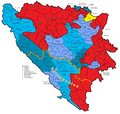
In the modern Bosnian-Herzegovinian state, Herzegovina is divided between two entities, جمهورية صرب البوسنة واتحاد البوسنة والهرسك. Republika Srpska's part of Herzegovina, commonly referred to as East Herzegovina or, as of late, "Trebinje Region", is administratively divided into municipalities of Trebinje, Bileća, Gacko, Nevesinje, Ljubinje, Berkovići, Istočni Mostar and Foča. Within the Federation of Bosnia and Herzegovina, Herzegovina is administratively divided between the cantons of الهرسك-نرتڤا، West Herzegovina and includes the Livno and Tomislavgrad municipalities, which is part of the Canton 10.
"الهرسك الشرقية" أو "منطقة تربينيى" في جمهورية صرب البوسنة.
كانتون الهرسك-نرتڤا في اتحاد البوسنة والهرسك
كانتون الهرسك الغربية في اتحاد البوسنة والهرسك
منطقة الهرسك الاقتصادية، مُخططة منذ 2013.


السكان
While the population of Herzegovina throughout history has been ethnically mixed, the حرب البوسنة in the 1990s resulted in mass ethnic cleansing and large-scale displacement of people. The last pre-war census in 1991 recorded a population of 437,095 inhabitants.

- Croats generally populate the areas closest to the Croatian border focused on موستار، Ljubuški, Široki Brijeg, Čitluk, Grude, Posušje, Čapljina, Neum, Stolac, Ravno, Prozor-Rama, Livno and Tomislavgrad.
- Bosniaks mainly live in the areas along the Neretva River, Konjic and Jablanica, as well as the eastern part of Mostar, and to significant extent Stolac, Čapljina, and lesser extent in Nevesinje, Gacko, Trebinje.
- Serbs are the majority in eastern Herzegovina, including the municipalities of Berkovići, Bileća, Gacko, Istočni Mostar, Ljubinje, Nevesinje, Foča and Trebinje.
التاريخ
| تاريخ الهرسك |
|---|
|
 مقالة مفصلة: تاريخ الهرسك
التاريخ المبكر
Slavs settled in the Balkans in the 7th century. What later became known as Herzegovina was divided between Croatia, Zachlumia and Travunija in the Early Middle Ages. Parts of the region were later ruled by various medieval rulers, with the eastern part mostly within Medieval Serbia, and the western part in the Kingdom of Croatia. Bosnian Ban Stjepan II Kotromanić and King Tvrtko I Kotromanić joined these regions to the Bosnian state in the 14th century.
أسرة كوساچا

إثر وهن التاج البوسني بعد وفاة تڤرتكو الأول، powerful noblemen of the Bosnian Kosača family, Grand Duke Sandalj Hranić and his nephew, Herzog Stefan Vukčić, ruled the Hum region independently, only nominally recognizing the overlordship of the Bosnian kings. In a document sent to Frederick III في 20 يناير 1448, Bosnian duke Stjepan Vukčić Kosača called himself هرتسوگ (دوق) القديس ساڤا, lord of Hum and Primorje, great duke of the Bosnian kingdom and so the lands he controlled became (much later) known as أراضي الهرتسوگ أو Herzegovina.
- تاريخ دوقية القديس ساڤا، من وجهة نظر صربية
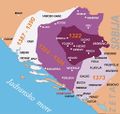
توسع مملكة البوسنة في القرن 14.
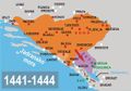
دوقية القديس ساڤا الكوساچية، 1440.
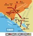
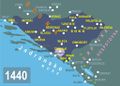
سقوط دوقية القديس ساڤا الكوساچية في يد زيتا (القرن 15).
سقوط دوقية القديس ساڤا الكوساچية في يد زيتا (القرن 15).

.jpg)


الفترة العثمانية


في 1482، أراضي خلفاء ستفان ڤوكچيتش احتلتها القوات العثمانية. وكان العثمانيون أول من استخدم بشكل رسمي الاسم Herzegovina (هرسك) للمنطقة. البايلرباي عيس بگ إسحاقوڤتش ذكر الاسم في رسالة من سنة 1454. في الدولة العثمانية، نـُطـِّمت الهرسك كـسنجق، سنجق الهرسك، ضمن إيالة البوسنة.
During the Long War (1591–1606), Serbs rose up in Herzegovina (1596–97), but they were quickly suppressed after their defeat at the field of Gacko. The Candian War of 1645 to 1669 caused great damage to the region as the Republic of Venice and the Ottoman Empire fought for control over Dalmatia and coastal Herzegovina. As a result of the Treaty of Karlowitz of 1699, the Ottomans gained access to the البحر الأدرياتي through the Neum-Klek coastal area. جمهورية دوبروڤنيك seceded this to distance themselves from the Venetian Republic's influence. The Ottomans benefitted from this in gaining the region's salt.
As a result of the Bosnian Uprising (1831–32), the Vilayet was split to form the separate Herzegovina Eyalet, ruled by semi-independent vizier Ali-paša Rizvanbegović. After his death, the eyalets of Bosnia and Herzegovina were merged. The new joint entity was after 1853 commonly referred to as البوسنة والهرسك. الصرب في المنطقة ثاروا ضد العثمانيين (1852–62) and were aided by the Montenegrins, who sought the liberation of the Serb people from Ottoman rule. The Herzegovinian Serbs frequently rose up against the Ottoman rule; culminating in the انتفاضة الهرسك (1875-78), which was supported by the إمارة صربيا والجبل الأسود. Montenegro did succeed in liberating and annexing large parts of Herzegovina before the Berlin Congress of 1878, including the Nikšić area; the historical Herzegovina region annexed to Montenegro is known as East or Old Herzegovina.
. . . . . . . . . . . . . . . . . . . . . . . . . . . . . . . . . . . . . . . . . . . . . . . . . . . . . . . . . . . . . . . . . . . . . . . . . . . . . . . . . . . . . . . . . . . . . . . . . . . . . . . . . . . . . . . . . . . . . . . . . . . . . . . . . . . . . . . . . . . . . . . . . . . . . . . . . . . . . . . . . . . . . . . .
التاريخ المعاصر
As a result of the Treaty of Berlin (1878), Herzegovina, along with Bosnia, was occupied by Austria-Hungary, only nominally remaining under Ottoman rule. The historical Herzegovina region in the Principality of Montenegro was known as East or Old Herzegovina. The Serb population of Herzegovina and Bosnia hoped for annexation to Serbia and Montenegro. The Franciscan order opened the first university in Herzegovina in 1895 in Mostar.
.svg)
In 1908, Austria-Hungary annexed the province, leading to the Bosnian Crisis, an international dispute which barely failed to precipitate a world war immediately, and was an important step in the buildup of international tensions during the years leading up to the First World War. The assassination of the Archduke Franz Ferdinand came as a direct result of the resentment of the Serbs of Bosnia and Herzegovina against Austro-Hungarian rule.
During World War I, Herzegovina was a scene of inter-ethnic conflict. During the war, the Austro-Hungarian government formed Šuckori, Muslim and Croat militia units. Šuckori units were especially active in Herzegovina.
In 1918, Herzegovina became a part of the newly formed Kingdom of Serbs, Croats and Slovenes (later renamed Kingdom of Yugoslavia). In 1941 Herzegovina fell once again under the rule of the fascist Independent State of Croatia. During World War II, Herzegovina was a battleground between fascist Croat Ustaše, royalist Serb Četniks, and the communist Yugoslav Partisans; Herzegovina was a part of the Independent State of Croatia, administratively divided into the counties of Hum and Dubrava, then in 1945, PR Bosnia and Herzegovina became one of the republics of Second Yugoslavia. It remained so until the breakup of Yugoslavia in the early 1990s.
During the Bosnian War, large parts of western and central Herzegovina came under control of the Croat republic of Herzeg-Bosnia (which later joined the Federation of Bosnia and Herzegovina) while eastern Herzegovina became a part of Republika Srpska.
الثقافة
الشواهد
الدين
الموسيقى
السياحة
In Herzegovina there are many beautiful and well-known natural landmarks, such as the falls of Kravica. These consist of several waterfalls near the city of Ljubuški and a popular spot for the local people, to take a bath in the hot Herzegovinian weather, or just to enjoy the view.
- The Hutovo Blato is a bird reserve, one of the most important in Europe and a gathering place for many international ornithologists.
- Vjetrenica cave is a cave system near the border with Croatia, in the Ravno municipality. The cave has not been explored totally yet, but it is open to visitors. More and more species are being discovered there and it is a unique ecosystem with cave animals and other interesting things.
- Blagaj is also known as the origin of the Buna River, inside a cave system.
- Neum at the Adriatic Sea, Bosnia and Herzegovina's only coastal town, is also a popular tourist attraction.
- Medjugorje has one of the most visited sites in Bosnia and Herzegovina, receiving more than one million visitors each year.
معرض صور
Rock formation "Hajdučka vrata" on Čvrsnica
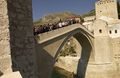
The "Old Bridge" ("Stari most") in Mostar, rebuilt in 2004.
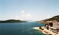
Neum and the Herzegovinian coast.
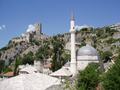
Počitelj, Old town
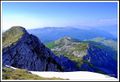
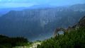
Čvrsnica
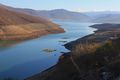
Bilećko jezero (Bileća Lake)


انظر أيضاً
الوضع السياسي
In the modern Bosnian-Herzegovinian state, Herzegovina is divided between two entities, جمهورية صرب البوسنة and the Federation of Bosnia and Herzegovina (see Bosnia and Herzegovina and History of Bosnia and Herzegovina). Republika Srpska's part of Herzegovina, commonly referred to as East Herzegovina or, as of late, Trebinje Region is administratively divided into municipalities of Trebinje, Bileća, Gacko, Nevesinje, Ljubinje, Berkovići, Istočni Mostar and Foča. Within the Federation of Bosnia and Herzegovina, Herzegovina is administratively divided between the cantons of Herzegovina-Neretva, West Herzegovina and includes part of Canton 10.
مراجع
- ^ "Bosnia and Herzegovina dictionary definition | Bosnia and Herzegovina defined". yourdictionary.com. Retrieved 2014-10-24.
- ^ Administrativno uređenje Hercegovine od 1945. do 1952. godine by Adnan Velagić, published in Most - časopis za obrazovanje, nauku i kulturu, No. 191, Year 2005 (October), pp. 82-84. ISSN 0350-6517
- ^ "Dictionary, Encyclopedia and Thesaurus - The Free Dictionary". encyclopedia.farlex.com. Retrieved 2014-10-24.
- ^ Ekonomska regija Hercegovina, Regionalna razvojna agencija za Hercegovinu (REDAH) in conjunction with the EU RED Project, Bosnia and Herzegovina, November, 2004, pp 24-26
- ^ Corporation, M.C. (2002). Peoples of Europe. Marshall Cavendish Corporation. p. 51. ISBN 9780761473787. Retrieved 2014-10-24.
- ^ Clancy, T. (2007). Bosnia and Herzegovina: The Bradt Travel Guide. Bradt Travel Guides. p. 3. ISBN 9781841621616. Retrieved 2014-10-24.
- ^ Official results from the book: Ethnic composition of Bosnia-Herzegovina population, by municipalities and settlements, 1991. census, Zavod za statistiku Bosne i Hercegovine - Bilten no.234, Sarajevo 1991. 1991.
روابط خارجية
- Visit Bosnia and Herzegovina
- Tourism in Herzegovina-Neretva Canton
- Culture of Lower Herzegovina
- Poskok (Vipera) - herzegovinian portal
| الجغرافية |  | |
|---|---|---|
| التاريخية | ||