ملف:Tithonium Chasma Layers.JPG
لا توجد دقة أعلى متوفرة.
Tithonium_Chasma_Layers.JPG (621 × 412 بكسل حجم الملف: 50 كيلوبايت، نوع MIME: image/jpeg)
وصف قصير
| Description |
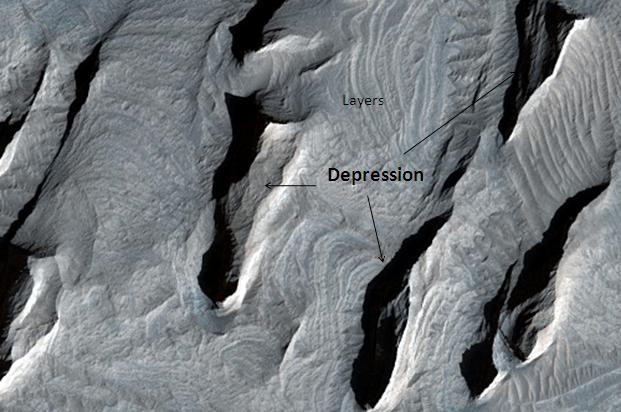
English: Tithonium Chasma layers. Location is 4.6 degrees south latitude and 270.4 degrees east longitude. Image was taken by the Mars Reconnaissance Orbiter's HiRISE. The HiRISE camera was built by Ball Aerospace and Technology corporation and is operated by the University of Arizona. Image courtesy NASA/JPL/University of Arizona. |
| Date | 2009-03-04 |
| Source | http://hirise.lpl.arizona.edu/PSP_007918_1755 |
| Author | Jim Secosky modified NASA image. |
ترخيص
قالب:Original upload log
| زمن/تاريخ | الأبعاد | مستخدم | تعليق |
|---|---|---|---|
| 2009-03-04 18:32 | 621×412× (51548 bytes) | Jimmarsmars | {{Information |Description=Tithonium Chasma Layers, as seen by hirise. Location is 4.6 degrees south latitude and 270.4 degrees east longitude. |Source=http://hirise.lpl.arizona.edu/PSP_007918_1755 |Date=March 4, 2009. |Author=Jim Secosky modified NASA i |
تاريخ الملف
اضغط على زمن/تاريخ لرؤية الملف كما بدا في هذا الزمن.
| زمن/تاريخ | صورة مصغرة | الأبعاد | مستخدم | تعليق | |
|---|---|---|---|---|---|
| حالي | ★ مراجعة معتمدة 13:39، 15 ديسمبر 2023 | | 621 × 412 (50 كيلوبايت) | Pastakhov (نقاش | مساهمات) | Upload https://upload.wikimedia.org/wikipedia/commons/5/57/Tithonium_Chasma_Layers.JPG |
لا يمكنك استبدال هذا الملف.
وصلات
لا يوجد صفحات تصل لهذه الصورة.