ملف:Rosewood Massacre Map.PNG

حجم هذه المعاينة: 659 × 599 بكسل. البعد الآخر: 742 × 675 بكسل.
الملف الأصلي (742 × 675 بكسل حجم الملف: 46 كيلوبايت، نوع MIME: image/png)
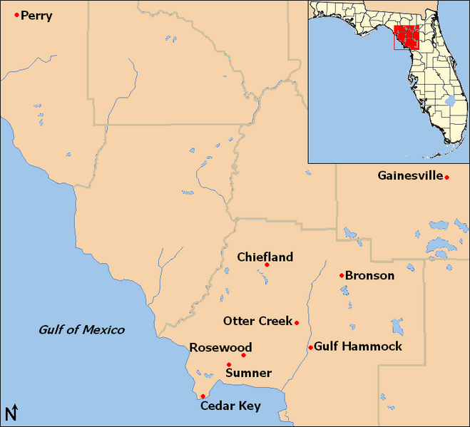
| Description | Map of locations mentioned in the Rosewood massacre article in northwestern Florida, United States. |
| Date | 2009-04 |
| Source | taken from US Census website [1] and modified by User:Ruhrfisch. Inset map is modified version of File:Map of Florida highlighting Gilchrist County.svg |
| Author | US Census, Ruhrfisch, inset is based on map by User:Dbenbenn |
| ⧼wm-license-information-permission⧽ (⧼wm-license-information-permission-reusing-text⧽) |
US Census / US Government work is public domain, my modifications licensed under the GNU Free Documentation License |

|
تاريخ الملف
اضغط على زمن/تاريخ لرؤية الملف كما بدا في هذا الزمن.
| زمن/تاريخ | صورة مصغرة | الأبعاد | مستخدم | تعليق | |
|---|---|---|---|---|---|
| حالي | ★ مراجعة معتمدة 15:38، 22 يناير 2024 | | 742 × 675 (46 كيلوبايت) | Pastakhov (نقاش | مساهمات) | Upload https://upload.wikimedia.org/wikipedia/commons/6/6a/Rosewood_Massacre_Map.PNG |
لا يمكنك استبدال هذا الملف.
وصلات
لا يوجد صفحات تصل لهذه الصورة.