ملف:Palestine Map 2007.gif
الملف الأصلي (780 × 970 بكسل حجم الملف: 103 كيلوبايت، نوع MIME: image/gif)
وصف قصير
This map is a modification, suggested as a replacement for the one uploaded by ChrisO at
which is used in the Wikipedia article "Palestine," under the History subheading Current Status.
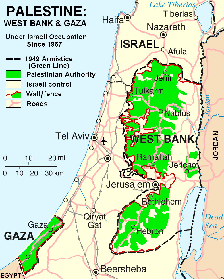
My modification shows "facts on the ground" which are essential to any understanding of the situation in Palestine today. The geographic facts are not in dispute. They have been widely published in print and on the internet.
Both my map and the ChrisO map are modifications of a 2004 United Nations map of Israel:
(public domain) in which the three Occupied Territories, the West Bank, Gaza, and Golan, are given the same brown color as Israel's neighboring countries: Egypt, Jordan, Syria, and Lebanon. ChrisO colors the West Bank, Gaza, and Golan light green and renames the map "Israel and the Occupied Territories." However Golan is Syrian, not Palestinian. For an article on Palestine, attention should be on the West Bank and Gaza.
My modification crops out Golan and the Negev desert to focus in on the West Bank and Gaza. It also incorporates information from several published sources to show the land and resources actually available to Palestinian people in these two territories, the West Bank in particular.
The main source of information on barriers and land distribution comes from a map by the United Nations Office for the Coordination of Humanitarian Affairs:
supplemented by two more United Nations maps:
- http://www.ochaopt.org/documents/WB_Barrier_Projections_July06.pdf Archive copy at the Internet Archive
- http://www.ochaopt.org/documents/WB_Closure_Access_revised_CAP_June06.pdf Archive copy at the Internet Archive
Two Israeli organizations have published similar maps:
- http://www.btselem.org/Download/Separation_Barrier_Map_Eng.pdf
- http://www.icahd.org/eng/images/articles/the-matrix-of-control.gif Archive copy at the Internet Archive
And finally, the Washington Post published all this information on a full-page newspaper map:
Each of these maps is much too detailed to illustrate a Wikipedia article. My modification simplifies the information for use on a map similar in scale to the other maps in the article on Palestine.
Similar maps with locations of Israeli settlements are posted at:
.gif&action=edit&redlink=1)
.gif&action=edit&redlink=1)
ترخيص
تاريخ الملف
اضغط على زمن/تاريخ لرؤية الملف كما بدا في هذا الزمن.
| زمن/تاريخ | صورة مصغرة | الأبعاد | مستخدم | تعليق | |
|---|---|---|---|---|---|
| حالي | ★ مراجعة معتمدة 07:06، 11 أبريل 2025 | | 780 × 970 (103 كيلوبايت) | Pastakhov (نقاش | مساهمات) | Upload https://upload.wikimedia.org/wikipedia/commons/2/2f/Palestine_Map_2007.gif |
لا يمكنك استبدال هذا الملف.
وصلات
لا يوجد صفحات تصل لهذه الصورة.