ملف:PH Administrative Map.svg

حجم معاينة PNG لذلك الملف ذي الامتداد SVG: 512 × 561 بكسل. البعد الآخر: 1٬869 × 2٬048 بكسل.
الملف الأصلي (ملف SVG، أبعاده 512 × 561 بكسل، حجم الملف: 2٫2 ميجابايت)
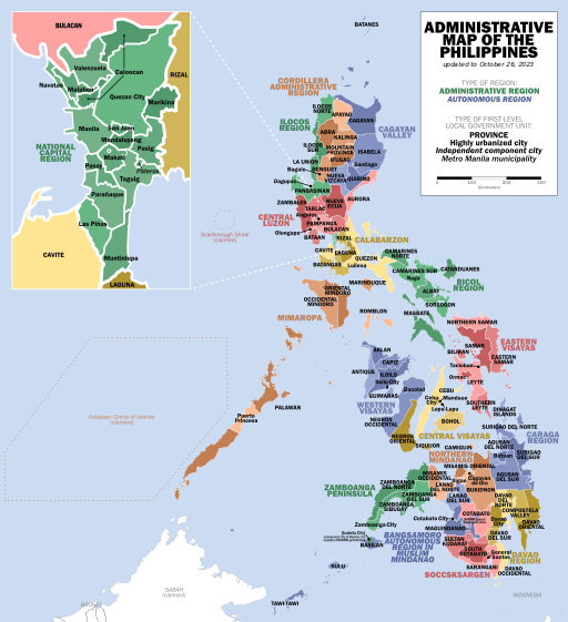
وصف قصير
| Description |
English: Map showing first-level political divisions of the Philippines, and the regions they are assigned to
(Tagalog) |
| Date | 2019-08-09 |
| Source | Own work; adapted from Felipe_Aira's Municipal and city map of the Philippines |
| Author | Dakilang Isagani |
.svg&action=edit&redlink=1)
ترخيص
|
تاريخ الملف
اضغط على زمن/تاريخ لرؤية الملف كما بدا في هذا الزمن.
| زمن/تاريخ | صورة مصغرة | الأبعاد | مستخدم | تعليق | |
|---|---|---|---|---|---|
| حالي | ★ مراجعة معتمدة 05:30، 26 يناير 2024 | | 512 × 561 (2٫2 ميجابايت) | Pastakhov (نقاش | مساهمات) | Upload https://upload.wikimedia.org/wikipedia/commons/4/43/PH_Administrative_Map.svg |
لا يمكنك استبدال هذا الملف.
وصلات
الصفحات التالية تحتوي على وصلة لهذه الصورة: