ملف:Manor Park Library, E12 - geograph.org.uk - 361696.jpg
لا توجد دقة أعلى متوفرة.
Manor_Park_Library,_E12_-_geograph.org.uk_-_361696.jpg (640 × 510 بكسل حجم الملف: 154 كيلوبايت، نوع MIME: image/jpeg)
وصف قصير
| Description |
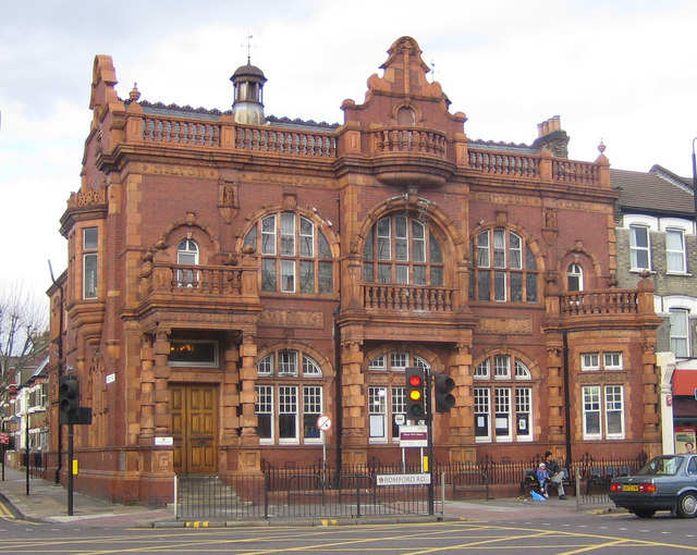
English: Manor Park Library, E12 This is the Romford Road façade of this ornate building, built at the junction with Rabbits Road. The Library was a Carnegie Library funded by the philanthropist Andrew Carnegie. The use of sandstone infilled with dark brickwork gives the impression of a building more typical of Carnegie Libraries in his native Scotland. The names Milton, Shakespeare, Tennyson and Carlyle are carved in the stonework immediately below the balustrade at roof level, while Dickens and Longfellow appear just below the lower balustrades. Over the main entrance on the left are carved the words "Let there be light", while "Carnegie" and "Library" appear on the main building frontage at the first floor level. |
| Date | 2007-03-07 |
| Source | From geograph.org.uk |
| Author | Nigel Cox |
| ⧼wm-license-cc-attribution⧽ (قالب:I18n/Credit line) |
Nigel Cox / Manor Park Library, E12 / |
51°33′10″N 0°03′11″E / 51.5527°N 0.053°E
_heading:337)
| Object location | ملف:Compass-icon bb NNW.svg | View all coordinates using: OpenStreetMap |
|---|
_heading:337.00&language=⧼lang⧽)
ترخيص
تاريخ الملف
اضغط على زمن/تاريخ لرؤية الملف كما بدا في هذا الزمن.
| زمن/تاريخ | صورة مصغرة | الأبعاد | مستخدم | تعليق | |
|---|---|---|---|---|---|
| حالي | ★ مراجعة معتمدة 01:00، 17 أكتوبر 2023 | | 640 × 510 (154 كيلوبايت) | Pastakhov (نقاش | مساهمات) | Upload https://upload.wikimedia.org/wikipedia/commons/9/94/Manor_Park_Library%2C_E12_-_geograph.org.uk_-_361696.jpg |
لا يمكنك استبدال هذا الملف.
وصلات
لا يوجد صفحات تصل لهذه الصورة.