ملف:Italy 1796 AD-it.png
حجم هذه المعاينة: 421 × 600 بكسل. البعد الآخر: 767 × 1٬093 بكسل.
الملف الأصلي (767 × 1٬093 بكسل حجم الملف: 231 كيلوبايت، نوع MIME: image/png)
وصف قصير
| Description |
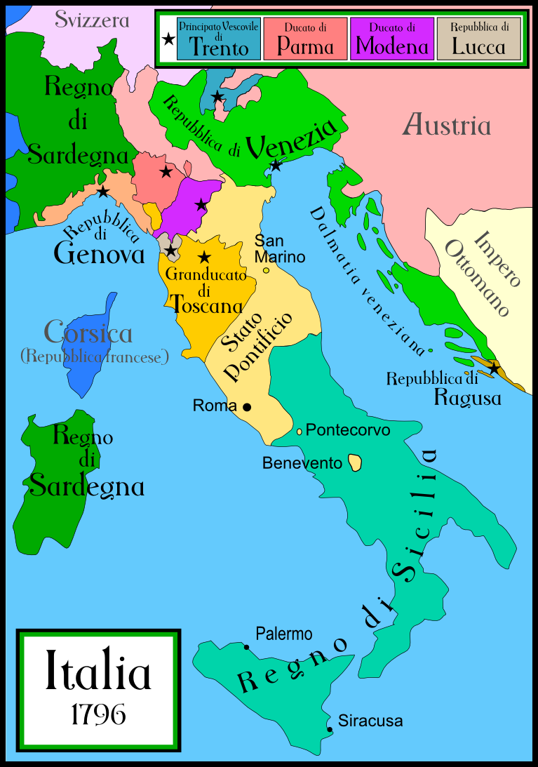
English: A political map of Italy in early 1796, before the Napoleonic wars, created by MapMaster.
This is a companion map to Image:Italy 1000 AD.svg, Image:Italy 1494 v2.png, and Image:Italy c 1810.png. This map uses a modified Mercator projection. |
| Date | قالب:Original upload date |
| Source | No machine-readable source provided. Own work assumed (based on copyright claims). |
| Author | No machine-readable author provided. MapMaster assumed (based on copyright claims). |
| ⧼wm-license-information-other-versions⧽ | قالب:Other versions/Italy 1796 AD |
References
- Bjorklund, Oddvar; Holmboe, Haakon; Rohr, Anders (1970) Historical Atlas of the World, Barnes & Noble, NY, SBN: 389-00253-4.
- Other maps, including Image:Italy 1796.jpg from the Historical Atlas by William R. Shepherd, 1926.
ترخيص
|

derivative works
تاريخ الملف
اضغط على زمن/تاريخ لرؤية الملف كما بدا في هذا الزمن.
| زمن/تاريخ | صورة مصغرة | الأبعاد | مستخدم | تعليق | |
|---|---|---|---|---|---|
| حالي | ★ مراجعة معتمدة 12:27، 11 أكتوبر 2023 | | 767 × 1٬093 (231 كيلوبايت) | Pastakhov (نقاش | مساهمات) | Upload https://upload.wikimedia.org/wikipedia/commons/7/7c/Italy_1796_AD-it.png |
لا يمكنك استبدال هذا الملف.
وصلات
لا يوجد صفحات تصل لهذه الصورة.
معلومات الصورة (ميتا)
تصنيفات:
- Files with no machine-readable source
- Self-published work
- 1796 in Italy
- 1796 maps of Europe
- Maps of the history of the Italian Peninsula
- Maps of historical states of Italy
- Maps of the Republic of Venice
- Maps of 18th-century Italy
- Maps of the Republic of Genoa
- Kingdom of Sardinia
- Maps of the history of Sardinia
- Maps of the Grand Duchy of Tuscany
- Maps of the Republic of Lucca
- Maps of the Duchy of Parma and Piacenza
- Maps of Duchy of Modena and Reggio
- Maps of the Papal States
- Maps of the Kingdom of Sicily