ملف:Israel Railways map 2013.svg

حجم معاينة PNG لذلك الملف ذي الامتداد SVG: 391 × 599 بكسل. البعد الآخر: 1٬336 × 2٬048 بكسل.
الملف الأصلي (ملف SVG، أبعاده 616 × 944 بكسل، حجم الملف: 366 كيلوبايت)
وصف قصير
| Description |
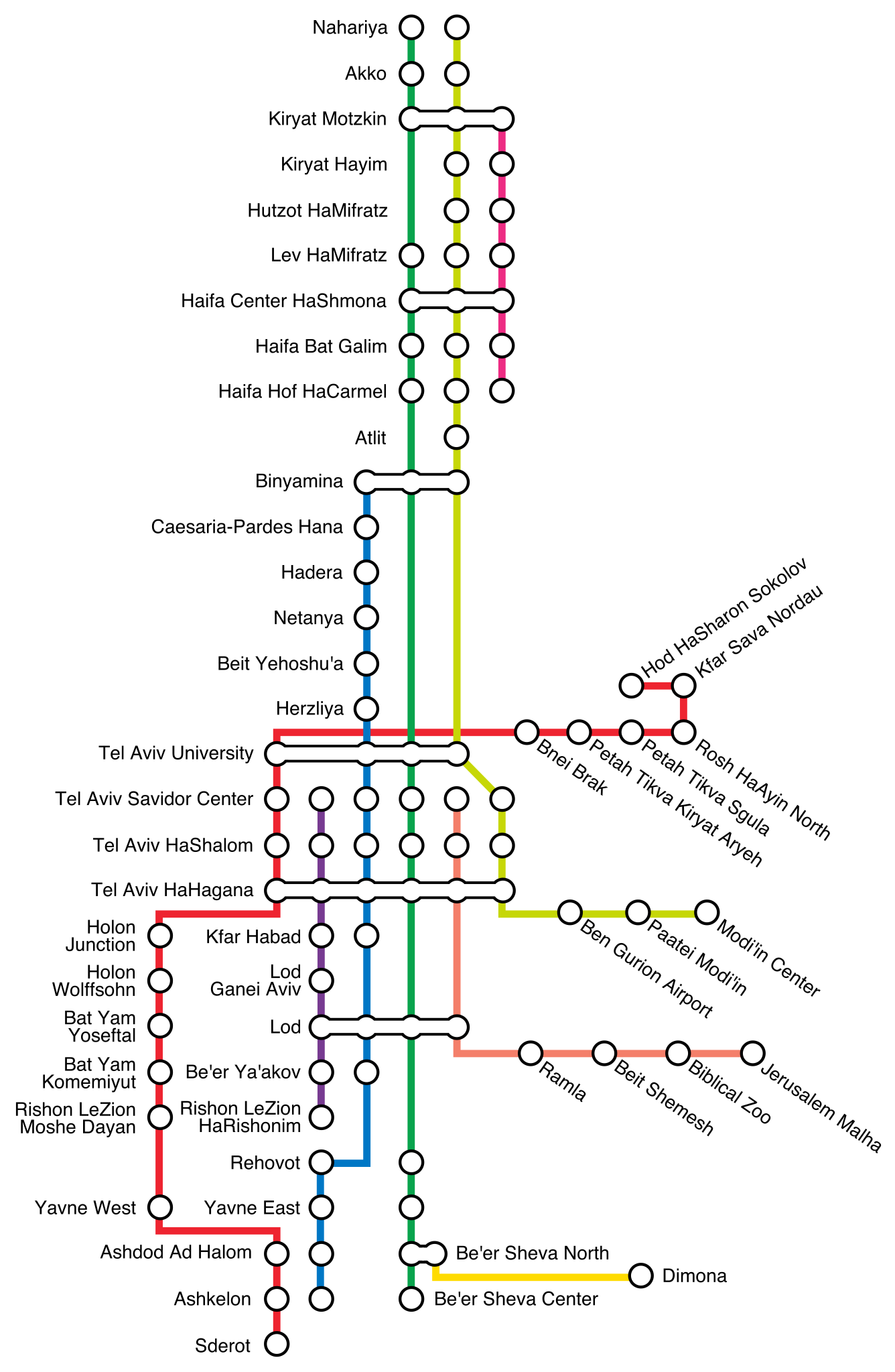
English: Israel Railways map as at August 2013 |
| Date | 2013-08-20 12:43 (UTC) |
| Source | قالب:Derived from |
| Author |
|
| ⧼wm-license-information-other-versions⧽ | قالب:Derivative work |
Note that the type for station names is created as paths, but plain type details and text are contained in a hidden svg layer to assist future editing. Font is Helvetica Regular 13pt. Rotation for "angled" names is +/- 35 degrees. |
| [This is a retouched picture, which means that it has been digitally altered from its original version. Modifications: Redrawn as vector and updated per this request at en WP Map workshop:
|
ترخيص
قالب:Original upload log
This image is a derivative work of the following images:
- File:Ir2011map2.png licensed with Cc-zero
- 2012-07-16T10:27:52Z Atefrat 2881x4328 (512622 Bytes) recommended transfer points based on official map
- 2012-07-11T06:56:44Z Atefrat 2453x4280 (486716 Bytes) stations on green line according to official sources
- 2012-05-23T14:03:35Z Atefrat 2453x4280 (486378 Bytes) adjust placement
- 2012-05-23T13:49:25Z Atefrat 2453x4280 (485039 Bytes) Yavne West station added
- 2012-05-23T13:45:58Z Atefrat 2453x4280 (485039 Bytes) Yavne West Station added
- 2011-10-19T09:04:15Z Atefrat 2453x4280 (480768 Bytes)
تاريخ الملف
اضغط على زمن/تاريخ لرؤية الملف كما بدا في هذا الزمن.
| زمن/تاريخ | صورة مصغرة | الأبعاد | مستخدم | تعليق | |
|---|---|---|---|---|---|
| حالي | ★ مراجعة معتمدة 05:24، 28 أكتوبر 2023 | | 616 × 944 (366 كيلوبايت) | Pastakhov (نقاش | مساهمات) | Upload https://upload.wikimedia.org/wikipedia/commons/1/16/Israel_Railways_map_2013.svg |
لا يمكنك استبدال هذا الملف.
وصلات
لا يوجد صفحات تصل لهذه الصورة.