ملف:Geographical and Magnetic Poles.png
حجم هذه المعاينة: 668 × 599 بكسل. البعد الآخر: 1٬028 × 922 بكسل.
الملف الأصلي (1٬028 × 922 بكسل حجم الملف: 174 كيلوبايت، نوع MIME: image/png)
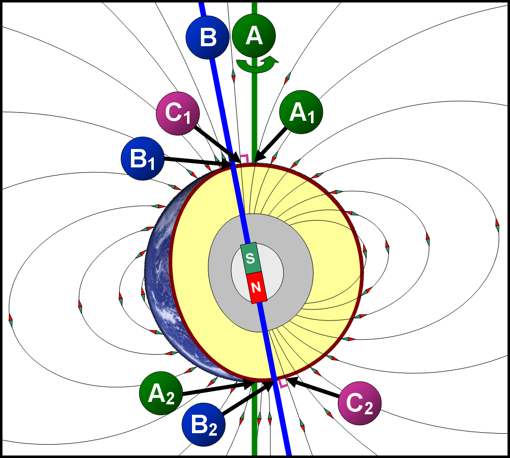
תרשים סכמטי של כדור הארץ
- A = ציר הסיבוב של כדור הארץ (מסומן בקו ירוק)
- A1 A2 = הקטבים הגאוגרפיים - הנקודות שבהן "חותך" ציר הסיבוב את פני כדור הארץ.
- הגלעין החיצוני (נוזלי) (מסומן בצבע אפור) - שכבה בכדור הארץ שבה נוצר השדה המגנטי, על פי w:he:תאוריית הדינמו.
- B = ציר הדו-קוטביות (מסומן בקו כחול) - הציר המגנטי הדו-קוטבי, המדמה מעין מוט מגנטי, שחלקו הצפוני הוא מגנט שמבחינה פיזיקלית נחשב ל"דרומי" (מסומן ב-S = South = דרום), ואילו חלקו הדרומי נחשב ל"צפוני" (N = North = צפון) מבחינה פיזיקלית. כיום, הזווית בין ציר זה לבין ציר הסיבוב של כדור הארץ היא 11.3°.
- B1 B2 = הקטבים הגאומגנטיים - הנקודות שבהן "חותך" ציר הדו-קוטביות את פני כדור הארץ.
- קווי השדה המגנטי (קווים שחורים דקים) - מתארים את כיוון השדה המגנטי מחוץ לגלעין.
- C1 C2 = הקטבים המגנטיים - הנקודות שבהן קווי השדה המגנטי (מסומנים בקווים שחורים) מאונכים לפני כדור הארץ (זווית של 90° בדיוק בגובה פני הקרקע). הקטבים המגנטיים אינם חופפים לקטבים הגאומגנטיים.
Schematic diagram of the Earth
- A = Earth's axis of rotation (marked with a green line)
- A1 A2 = the geographical poles - the points at which the axis of rotation "cuts" the axis of rotation of the earth.
- The outer core (liquid) (marked in gray) - a layer on Earth where the magnetic field is formed, according to the dynamo theory.
- B = Bipolar Axis (marked with a blue line) - The bipolar magnetic axis, which simulates a kind of magnetic rod, the northern part of which is a magnet that is physically considered "southern" (marked with S = South = South), while its southern part Is considered "North" (N = North = North) physically. Today, the angle between this axis and the axis of rotation of the Earth is 11.3 °.
- B1 B2 = the geomagnetic poles - the points at which the bipolar axis "cuts" the earth's surface.
- Magnetic field lines (thin black lines) - describe the direction of the magnetic field outside the nucleus.
- C1 C2 = The magnetic poles - the points at which the magnetic field lines (marked with black lines) are perpendicular to the Earth (an angle of 90 ° exactly at ground level). The magnetic poles do not overlap with the geomagnetic poles.
وصف قصير
| Description | A=Geographic poles, B=Geomagnetic poles, C=Magnetic poles |
| Date | 2007-11-03 |
| Source | Own work |
| Author | DMY |
ترخيص
|

تاريخ الملف
اضغط على زمن/تاريخ لرؤية الملف كما بدا في هذا الزمن.
| زمن/تاريخ | صورة مصغرة | الأبعاد | مستخدم | تعليق | |
|---|---|---|---|---|---|
| حالي | ★ مراجعة معتمدة 09:25، 18 يوليو 2025 | | 1٬028 × 922 (174 كيلوبايت) | Pastakhov (نقاش | مساهمات) | Upload https://upload.wikimedia.org/wikipedia/commons/2/29/Geographical_and_Magnetic_Poles.png |
لا يمكنك استبدال هذا الملف.
وصلات
لا يوجد صفحات تصل لهذه الصورة.