ملف:FAA JFK Airport map 2016.pdf

حجم معاينة JPG لذلك الملف ذي الامتداد PDF: 390 × 599 بكسل.
الملف الأصلي (806 × 1٬237 بكسل حجم الملف: 240 كيلوبايت، نوع MIME: application/pdf)
وصف قصير
| Description |
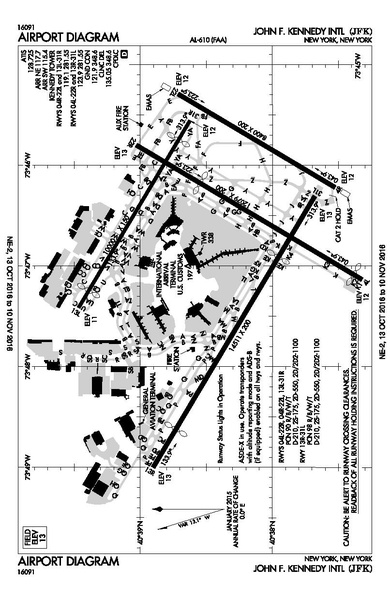
English: Aiport diagram of John F. Kennedy International aiport, as published by the FAA, containing runway and taxiway information among other aeronautical markers. |
| Date | 2016-10-13 |
| Source | https://www.faa.gov/airports/runway_safety/diagrams/ |
| Author | Federal Aviation Administration |
40°38′23″N 73°46′44″W / 40.639722°N 73.778889°W
ترخيص
تاريخ الملف
اضغط على زمن/تاريخ لرؤية الملف كما بدا في هذا الزمن.
| زمن/تاريخ | صورة مصغرة | الأبعاد | مستخدم | تعليق | |
|---|---|---|---|---|---|
| حالي | ★ مراجعة معتمدة 19:14، 11 أكتوبر 2023 |  | 806 × 1٬237 (240 كيلوبايت) | Pastakhov (نقاش | مساهمات) | Upload https://upload.wikimedia.org/wikipedia/commons/3/30/FAA_JFK_Airport_map_2016.pdf |
لا يمكنك استبدال هذا الملف.
وصلات
لا يوجد صفحات تصل لهذه الصورة.