ملف:Denny Regrade borders.jpg
لا توجد دقة أعلى متوفرة.
Denny_Regrade_borders.jpg (329 × 219 بكسل حجم الملف: 61 كيلوبايت، نوع MIME: image/jpeg)
وصف قصير
| Description |
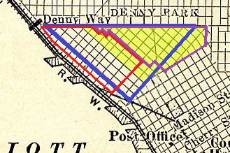
English: A map of showing different ways of defining Seattle's "Belltown", "Denny Regrade" and "Denny Triangle" neighborhoods. The yellow background shows the definition of "Denny Regrade" given in the Seattle City Clerk's Neighborhood Map Atlas. With blue border, "Belltown (Denny Regrade)" as defined by http://www.northwestplaces.com/tripsSea/A-Sea-Cent/Downtown01Map.htm. With red border, "Belltown" and with purple border "Denny Triangle", as defined by http://www.downtownseattle.com/blog/wp-content/uploads/2011/09/MIDMarketingNeighborhoodsMap_Cropped.jpg. Underlying map is the now-public-domain map of Seattle in 1914, published in the book New Geographies (1914) by Tarr & McMurry. |
|||
| Date | Underlying map ح. 1914, overlay 2014 | |||
| Source | Map from New Geographies (1914), modified by Joe Mabel | |||
| Author | Tarr & McMurry for underlying map; color and some cleanup by Joe Mabel | |||
| ⧼wm-license-information-permission⧽ (⧼wm-license-information-permission-reusing-text⧽) |
Underlying map: قالب:PD-1923 Overlay:
|
|||
| ⧼wm-license-information-other-versions⧽ | قالب:Derived from |
تاريخ الملف
اضغط على زمن/تاريخ لرؤية الملف كما بدا في هذا الزمن.
| زمن/تاريخ | صورة مصغرة | الأبعاد | مستخدم | تعليق | |
|---|---|---|---|---|---|
| حالي | ★ مراجعة معتمدة 06:41، 18 أكتوبر 2023 | | 329 × 219 (61 كيلوبايت) | Pastakhov (نقاش | مساهمات) | Upload https://upload.wikimedia.org/wikipedia/commons/c/c1/Denny_Regrade_borders.jpg |
لا يمكنك استبدال هذا الملف.
وصلات
لا يوجد صفحات تصل لهذه الصورة.