ملف:Coprates map.JPG
لا توجد دقة أعلى متوفرة.
Coprates_map.JPG (638 × 424 بكسل حجم الملف: 61 كيلوبايت، نوع MIME: image/jpeg)
وصف قصير
| Description |
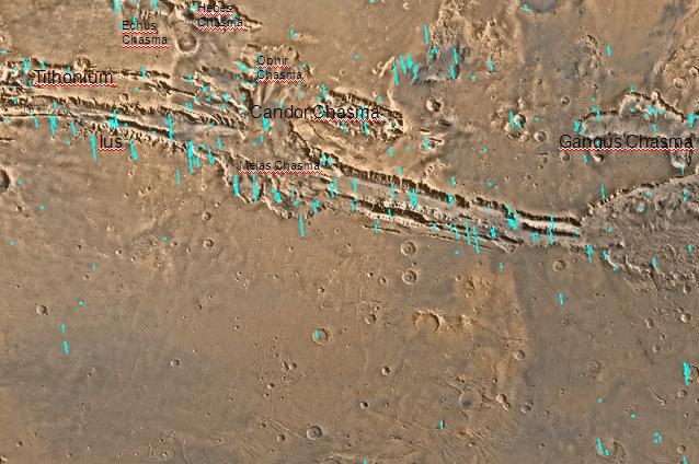
English: Labeled map of Coprates quadrangle, Mars. The small, colored rectangles represent image footprints for the narrow angle camera on the Mars Global Surveyor. Some are about 1 mile wide, the otheers are about 2 miles wide. The map was made by the U.S. Geological survey for NASA. |
| Date |
|
| Source | http://www.msss.com/moc_gallery/s05_s10/mc18.html |
| Author | Jim Secosky modified NASA map |
ترخيص
قالب:Original upload log
قالب:Transferred from قالب:Original description page
- 2008-12-29 19:53 Jimmarsmars 638×424× (62529 bytes) {{Information |Description=Labeled map of Coprates Mars |Source=http://www.msss.com/moc_gallery/s05_s10/mc18.html |Date=December 29, 2008 |Author=Jim Secosky modified NASA map. |Permission= |other_versions= }}
تاريخ الملف
اضغط على زمن/تاريخ لرؤية الملف كما بدا في هذا الزمن.
| زمن/تاريخ | صورة مصغرة | الأبعاد | مستخدم | تعليق | |
|---|---|---|---|---|---|
| حالي | ★ مراجعة معتمدة 17:42، 22 يناير 2024 | | 638 × 424 (61 كيلوبايت) | Pastakhov (نقاش | مساهمات) | Upload https://upload.wikimedia.org/wikipedia/commons/1/16/Coprates_map.JPG |
لا يمكنك استبدال هذا الملف.
وصلات
لا يوجد صفحات تصل لهذه الصورة.