ملف:'Front of Tibet' Map Painted by Wu Run-De (1907).jpg

حجم هذه المعاينة: 725 × 600 بكسل. البعد الآخر: 1٬000 × 827 بكسل.
الملف الأصلي (1٬000 × 827 بكسل حجم الملف: 299 كيلوبايت، نوع MIME: image/jpeg)
وصف قصير
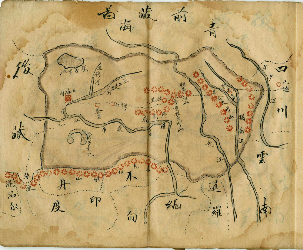
| Description |
English: 'Front of Tibet' (侯藏, or Ü). Map Painted by Wu Run-De in the 'Ding Wei' year after 1901, which would have been 1907. Political regions shown clockwise from top are Qinghai (青海), Sichuan (四川), Yunnan (雲南), Xianluo (暹罗, Thailand), Miandian (Burma), Budan (不丹, Bhutan), Yindu (印度, India), Nebo'er (尼泊尔, Nepal), and so-called 'Houzang' (侯藏, 'back of Tibet', or Tsang).
Français : Tibet avant (侯藏, ou Ü). Carte peinte par Wu Run-De dans le Ding Wei, quelques années après 1901, qui pourrait être 1907. Les régions politiques, montrées, sont, dans le sens des aiguilles d'une montre, Qinghai (青海), Sichuan (四川), Yunnan (雲南), Xianluo (暹罗, Thaïlande), Miandian (Burma), Budan (不丹, Bhoutan), Yindu (印度, Inde), Nebo'er (尼泊尔, Népal), et le, nommé alors 'Houzang' (侯藏, Tibet arrière, ou Tsang). |
| Date | 1907-03-01 |
| Source | http://chinesehsc.org/html_images/chinese_cartography/chinese_maps_of_the_world/enlargements/maps.of.the.earth.008.jpg |
| Author | Wu Run-De |
ترخيص
|
قالب:PD-1923
The official position taken by the Wikimedia Foundation is that "faithful reproductions of two-dimensional public domain works of art are public domain, and that claims to the contrary represent an assault on the very concept of a public domain". For details, see Commons:When to use the PD-Art tag.
|
تاريخ الملف
اضغط على زمن/تاريخ لرؤية الملف كما بدا في هذا الزمن.
| زمن/تاريخ | صورة مصغرة | الأبعاد | مستخدم | تعليق | |
|---|---|---|---|---|---|
| حالي | ★ مراجعة معتمدة 20:15، 25 أكتوبر 2023 | | 1٬000 × 827 (299 كيلوبايت) | Pastakhov (نقاش | مساهمات) | Upload https://upload.wikimedia.org/wikipedia/commons/0/07/%27Front_of_Tibet%27_Map_Painted_by_Wu_Run-De_%281907%29.jpg |
لا يمكنك استبدال هذا الملف.
وصلات
الصفحات التالية تحتوي على وصلة لهذه الصورة:
معلومات الصورة (ميتا)
.jpg&oldid=3253801)
تصنيفات:
- Chinese maps of Tibet
- Old maps of Yunnan
- Old maps of Sichuan
- Old maps of Bhutan
- Old maps of Assam
- Old maps of Arunachal Pradesh
- Old maps of Chuanbian
- 20th-century maps of Nepal
- Old maps of Qinghai
- Historical images of Qinghai
- Maps of the Yangtze River
- 1907 in Tibet
- Maps of Kham
- Maps of the Brahmaputra
- Maps of the Salween River
- Maps of the Mekong
- Ü (dBus)