ولونگونگ
}}}}
| ولونگونگ Wollongong New South Wales | |||||||||
|---|---|---|---|---|---|---|---|---|---|
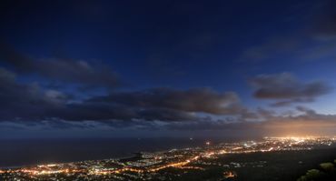 Overlooking Wollongong at night | |||||||||
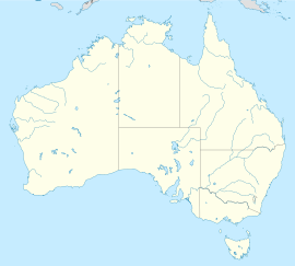
| Coordinates | 34°25′59″S 150°52′59″E / 34.43306°S 150.88306°E | ||||||||
| Population | 302,739 (2018) (10th) | ||||||||
| • Density | 529٫08/km2 (1٬370٫31/sq mi) | ||||||||
| Postcode(s) | 2500 | ||||||||
| Elevation | 5 m (16 ft) | ||||||||
| Area | 572٫2 km2 (220٫9 sq mi) | ||||||||
| Time zone | AEST (UTC+10) | ||||||||
| • Summer (DST) | AEDT (UTC+11) | ||||||||
| Location | 68 km (42 mi) S of Sydney | ||||||||
| LGA(s) |
| ||||||||
| Region | Illawarra | ||||||||
| Federal division(s) | |||||||||
| |||||||||
Error: unknown |type= value (help) | |||||||||
ولونگونگ (Wollongong ؛ /ˈwʊlənɡɒŋ/ WUUL-ən-gong), informally referred to as "The Gong", is a seaside city located in the Illawarra region of New South Wales, Australia. Wollongong lies on the narrow coastal strip between the Illawarra Escarpment and the Pacific Ocean, 68 kilometres (42 miles) south of central Sydney.[1] Wollongong had an estimated urban population of 302,739 at June 2018, making it the third-largest city in New South Wales after Sydney and Newcastle, and the tenth-largest city in Australia.[2] The city's current Lord Mayor is Gordon Bradbery AM who was elected in 2018.
The Wollongong metropolitan area extends from Helensburgh in the north to Shell Cove in the south. It sits within the Wollongong Statistical District, which covers the local authority areas of Wollongong, Shellharbour and Kiama, extending from the town of Helensburgh in the north, to Gerroa in the south[3] Geologically, the city is located in the south-eastern part of the Sydney basin, which extends from Newcastle to Nowra.[4]
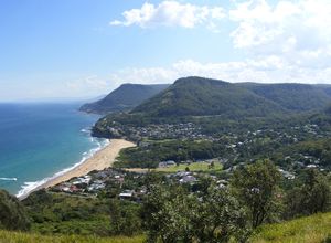
Wollongong is noted for its heavy industry, its port activity and the quality of its physical setting, occupying a narrow coastal plain between an almost continuous chain of surf beaches and the cliffline of the rainforest-covered Illawarra escarpment. It has two cathedrals, churches of many denominations and the Nan Tien Temple, the largest Buddhist temple in the southern hemisphere.[5] Wollongong has a long history of coal mining and industry. The city attracts many tourists each year,[6] and is a regional centre for the South Coast fishing industry. The University of Wollongong has around 37,000 students[7] and is internationally recognised.[8]
The name "Wollongong" is believed to mean "seas of the South" in the local Aboriginal language, Tharawal, referring to NSW's Southern Coast[citation needed]. Other meanings have been suggested, such as "great feast of fish", "hard ground near water", "song of the sea", "sound of the waves", "many snakes" and "five islands".[9][10][11][12][13][14]
التاريخ
الجغرافيا
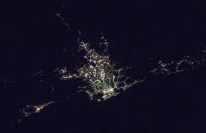
The city of Wollongong has a distinct geography. It lies on a narrow coastal plain flanked by the Tasman Sea to the east and a steep sandstone precipice known as the Illawarra Escarpment to the west. The coastal plain is widest in the south and narrowest in the north, with the city centre located about midway. South of the city centre but within the urban area is Lake Illawarra, a large lagoon.
| بيانات المناخ لـ جامعة ولونگونگ | |||||||||||||
|---|---|---|---|---|---|---|---|---|---|---|---|---|---|
| الشهر | ينا | فب | مار | أبر | ماي | يون | يول | أغس | سبت | أكت | نوف | ديس | السنة |
| القصوى القياسية °س (°ف) | 44.1 (111.4) |
41.7 (107.1) |
40.2 (104.4) |
35.4 (95.7) |
28.5 (83.3) |
24.7 (76.5) |
25.7 (78.3) |
30.3 (86.5) |
34.2 (93.6) |
38.8 (101.8) |
40.6 (105.1) |
41.5 (106.7) |
44.1 (111.4) |
| متوسط القصوى اليومية °س (°ف) | 25.8 (78.4) |
25.8 (78.4) |
24.5 (76.1) |
22.6 (72.7) |
20.1 (68.2) |
17.9 (64.2) |
17.2 (63.0) |
18.6 (65.5) |
20.7 (69.3) |
22.5 (72.5) |
23.1 (73.6) |
24.9 (76.8) |
22.0 (71.6) |
| متوسط الدنيا اليومية °س (°ف) | 17.9 (64.2) |
18.1 (64.6) |
16.6 (61.9) |
13.8 (56.8) |
11.6 (52.9) |
9.6 (49.3) |
8.4 (47.1) |
8.6 (47.5) |
10.5 (50.9) |
12.5 (54.5) |
14.2 (57.6) |
16.3 (61.3) |
13.2 (55.8) |
| الصغرى القياسية °س (°ف) | 9.6 (49.3) |
10.3 (50.5) |
9.1 (48.4) |
5.1 (41.2) |
3.1 (37.6) |
2.0 (35.6) |
0.8 (33.4) |
2.0 (35.6) |
3.3 (37.9) |
4.7 (40.5) |
5.4 (41.7) |
8.3 (46.9) |
0.8 (33.4) |
| متوسط تساقط الأمطار mm (inches) | 130.3 (5.13) |
156.4 (6.16) |
160.4 (6.31) |
129.3 (5.09) |
106.4 (4.19) |
112.4 (4.43) |
63.4 (2.50) |
83.3 (3.28) |
67.4 (2.65) |
100.5 (3.96) |
115.6 (4.55) |
94.6 (3.72) |
1٬320٫9 (52.00) |
| Average rainy days | 13.8 | 13.7 | 14.5 | 11.2 | 10.8 | 9.7 | 8.5 | 7.8 | 9.3 | 11.4 | 13.6 | 13.0 | 137.3 |
| متوسط الرطوبة النسبية بعد الظهر (%) | 68 | 69 | 66 | 63 | 62 | 59 | 54 | 52 | 55 | 61 | 64 | 64 | 61 |
| Source: [15] | |||||||||||||
الديمغرافيا
المعالم
In addition to numerous swimming and surfing beaches, major visitor attractions to the Wollongong region include:
|
|
المدن الشقيقة والصديقة
Wollongong has sister city and friendship city arrangements with:[16]
- Kawasaki, Japan, formally established 1988
- Ohrid, North Macedonia, established 1981, lapsed, formally re-established 1999
- Longyan, People's Republic of China (friendship city), formally established 2001
أشخاص بارزون
See List of people from Wollongong.
انظر أيضاً
- List of tallest buildings in Wollongong
- List of Wollongong suburbs
- Norman Gunston and Aunty Jack Sings Wollongong
- HMAS Wollongong
المراجع
- ^ Distance from Hyde Park in Sydney city center to Wollongong railway station in Wollongong city center – Google Maps
- ^ "Regional Population Growth, Australia, 2016–17". ABS. Archived from the original on 26 April 2018. Retrieved 6 October 2018.
- ^ "Wollongong Statistical District Map". Australian Bureau of Statistics. Retrieved 2 January 2009.
- ^ "Basin gif". Dept of Primary Industries. Archived from the original on 17 September 2011. Retrieved 12 July 2011.
- ^ "Nan Tien Temple Home Page". Nan Tien Temple. Archived from the original on 21 مارس 2009. Retrieved 31 أغسطس 2008.
- ^ "Illawarra Facts & Figures". Tourism NSW. Archived from the original on 25 مايو 2009. Retrieved 2 يناير 2009.
- ^ "Key Statistics". University of Wollongong. Archived from the original on 17 ديسمبر 2008. Retrieved 2 يناير 2009.
- ^ "Awards and Achievements". University of Wollongong. Archived from the original on 17 ديسمبر 2008. Retrieved 2 يناير 2009.
- ^ "Place Names of Wollongong". Wollongong City Library. Archived from the original on 21 أبريل 2008. Retrieved 8 مايو 2008.
- ^ McCarthy, F. D., The Australian Museum: New South Wales Aboriginal Place Names and Euphonious Words, with their Meanings, 3rd ed., Australian Museum, Sydney, 1959.
- ^ Illawarra Historical Society Bulletin, Illawarra Historical Society, Wollongong, 1945–
- ^ Cousins, Arthur, The Garden of New South Wales, Producers' Co-op. Distributing Society Ltd, Sydney, 1948.
- ^ Shaw, Hilde J., 200 Facts About Historic Illawarra, Illawarra Historical Society, Wollongong, 1970
- ^ McDonald, W. G., Earliest Illawarra: By its Explorers and Pioneers, Illawarra Historical Society, [Wollongong], 1966.
- ^ خطأ استشهاد: وسم
<ref>غير صحيح؛ لا نص تم توفيره للمراجع المسماةBOM_Woll - ^ "Sister cities". Wollongong City Council. 26 يوليو 2010. Archived from the original on 17 أكتوبر 2010. Retrieved 7 نوفمبر 2010.
وصلات خارجية
- Wollongong City Council
- "Illawarra From Above" – Satellite and Aerial Video
- Tourism Wollongong
- Wollongong – Visit NSW
- Wollongong Advertiser incorporating Lake Times
- Kiama Independent
- Merrigong Theatre Company
- Wollongong Town Hall
- Wollongong TV Guide – All channels currently broadcasting in the Wollongong and surrounding areas
- Pages using gadget WikiMiniAtlas
- Short description is different from Wikidata
- Coordinates on Wikidata
- Australian place articles with no population footnotes
- Articles with unsourced statements from April 2020
- Pages with empty portal template
- ولونگونگ
- مدينة ولونگونگ
- تأسيسات 1834 في أستراليا
- مدن ساحلية في أستراليا
- أماكن مأهولة تأسست في 1834
- Port cities in New South Wales
