ملف:White Church Lane, Whitechapel - geograph.org.uk - 594562.jpg
لا توجد دقة أعلى متوفرة.
White_Church_Lane,_Whitechapel_-_geograph.org.uk_-_594562.jpg (640 × 427 بكسل حجم الملف: 91 كيلوبايت، نوع MIME: image/jpeg)
وصف قصير
| Description |
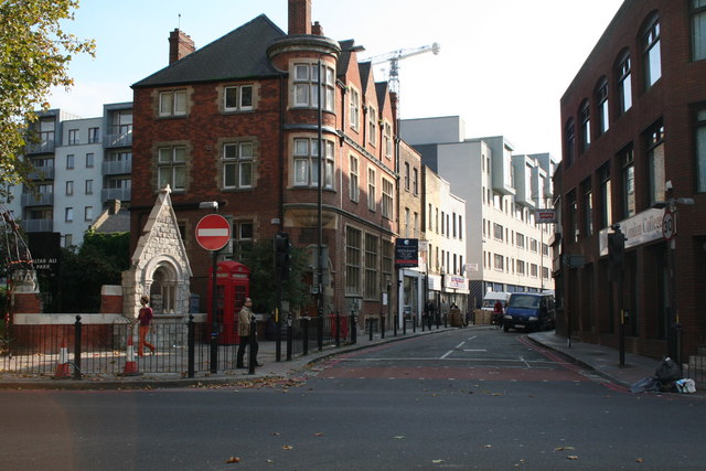
English: White Church Lane, Whitechapel This is taken from outside Aldgate East station, and White Church Lane is the road opposite. The white archway on the left once led to St. Mary's Church, but the rest of the church was accounted for by the Luftwaffe in 1941. The site is now a small park called Altab Ali park. |
| Date | 2007-10-23 |
| Source | From geograph.org.uk |
| Author | Dr Neil Clifton |
| ⧼wm-license-cc-attribution⧽ (قالب:I18n/Credit line) |
Dr Neil Clifton / Church Lane, Whitechapel / |
51°30′59″N 0°04′11″W / 51.51630°N 0.0697°W
_region:GB-ENG_heading:157)
| Object location | ملف:Compass-icon bb SE.svg | View all coordinates using: OpenStreetMap |
|---|
_heading:135.00&language=⧼lang⧽)
ترخيص
تاريخ الملف
اضغط على زمن/تاريخ لرؤية الملف كما بدا في هذا الزمن.
| زمن/تاريخ | صورة مصغرة | الأبعاد | مستخدم | تعليق | |
|---|---|---|---|---|---|
| حالي | ★ مراجعة معتمدة 01:47، 14 أكتوبر 2023 | | 640 × 427 (91 كيلوبايت) | Pastakhov (نقاش | مساهمات) | Upload https://upload.wikimedia.org/wikipedia/commons/9/96/White_Church_Lane%2C_Whitechapel_-_geograph.org.uk_-_594562.jpg |
لا يمكنك استبدال هذا الملف.
وصلات
لا يوجد صفحات تصل لهذه الصورة.
معلومات الصورة (ميتا)
تصنيفات:
- Pages using gadget WikiMiniAtlas
- Telephone boxes in the London Borough of Tower Hamlets
- Streets in the London Borough of Tower Hamlets
- Photographs by Dr Neil Clifton
- Drinking Fountain, White Church Lane
- White Church Lane, London
- K2 telephone kiosks in London
- October 2007 in London
- 2007 in the London Borough of Tower Hamlets
- No entry road signs in London
- United Kingdom photographs taken on 2007-10-23
- صفحات مع الخرائط