ملف:Wenatchee MODIS 2021-07-03 and 2021-07-05.jpg
حجم هذه المعاينة: 800 × 303 بكسل. البعد الآخر: 1٬082 × 410 بكسل.
الملف الأصلي (1٬082 × 410 بكسل حجم الملف: 85 كيلوبايت، نوع MIME: image/jpeg)
وصف قصير
| Description |
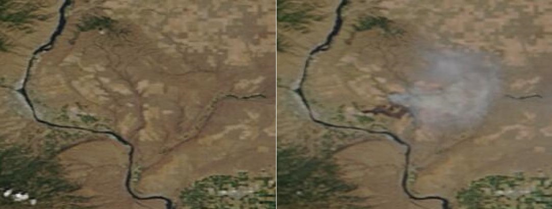
English: Map is roughly centered on Badger Mountain (47.4391667 N -120.0727778 W) inside the crook of the Big Bend of the Columbia River.
Columbia River runs north-south through the image. Wenatchee and East Wenatchee at the left edge of the images. Rock Island Creek and Douglas Creek canyons are visible in both images, north and east of the bend in the Columbia. Dark brown burn scar of the Batterman Fire is visible in right hand image is about 10 km long east-west. Total visible smoke plume is 20 km east-west. |
| Date | 2021-07-05 |
| Source | NASA Earth Science Data and Information System (ESDIS) Worldview viewer https://worldview.earthdata.nasa.gov/ |
| Author | NASA (Terra satellite MODIS sensor) |
ترخيص
تاريخ الملف
اضغط على زمن/تاريخ لرؤية الملف كما بدا في هذا الزمن.
| زمن/تاريخ | صورة مصغرة | الأبعاد | مستخدم | تعليق | |
|---|---|---|---|---|---|
| حالي | ★ مراجعة معتمدة 02:54، 6 أكتوبر 2023 | 1٬082 × 410 (85 كيلوبايت) | Pastakhov (نقاش | مساهمات) | Upload https://upload.wikimedia.org/wikipedia/commons/1/12/Wenatchee_MODIS_2021-07-03_and_2021-07-05.jpg |
لا يمكنك استبدال هذا الملف.
وصلات
لا يوجد صفحات تصل لهذه الصورة.