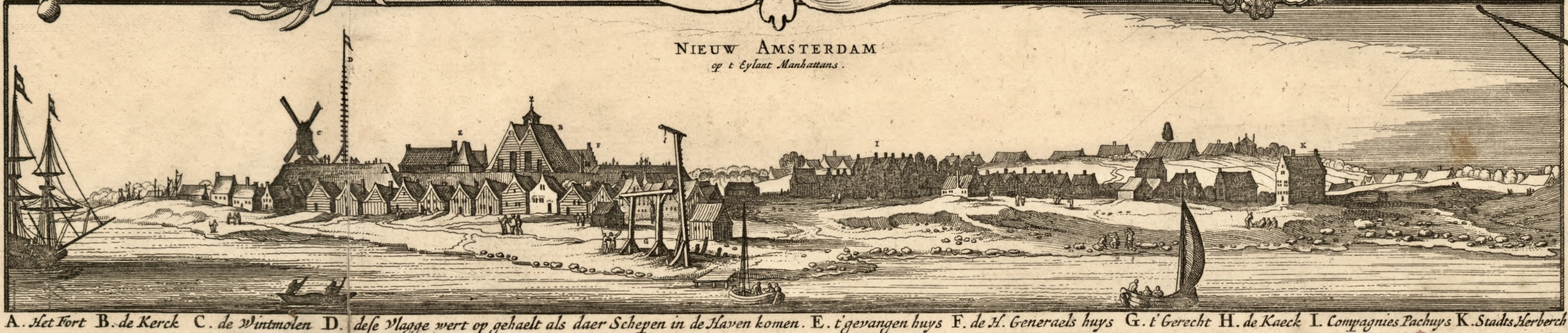
ملف:View of New Amsterdam from the harbor.jpg
حجم هذه المعاينة: 800 × 170 بكسل. البعد الآخر: 3٬630 × 771 بكسل.
الملف الأصلي (3٬630 × 771 بكسل حجم الملف: 3 ميجابايت، نوع MIME: image/jpeg)
وصف قصير
| Description |
English: Inset from: Novi Belgii Novæque Angliæ : nec non partis Virginiæ tabula multis in locis emendata |
| Date | ح. 1685 |
| Source | قالب:LOC-map |
| Author | صانع:Nicolaes Visscher II |
| ⧼wm-license-information-other-versions⧽ |
|
.jpg&filetimestamp=20120312231536&)
ترخيص
تاريخ الملف
اضغط على زمن/تاريخ لرؤية الملف كما بدا في هذا الزمن.
| زمن/تاريخ | صورة مصغرة | الأبعاد | مستخدم | تعليق | |
|---|---|---|---|---|---|
| حالي | ★ مراجعة معتمدة 15:11، 23 نوفمبر 2023 | 3٬630 × 771 (3 ميجابايت) | Pastakhov (نقاش | مساهمات) | Upload https://upload.wikimedia.org/wikipedia/commons/0/01/View_of_New_Amsterdam_from_the_harbor.jpg |
لا يمكنك استبدال هذا الملف.
وصلات
لا يوجد صفحات تصل لهذه الصورة.
معلومات الصورة (ميتا)
تصنيفات:
- Adriaen van der Donck
- Maps made in the 17th century
- 1685 maps
- Old maps of New York (state)
- Maps of the Hudson River
- Maps of Nieuw Nederland
- New Amsterdam
- Novi Belgii, Atlas Maior
- Maps by Nicolaes Visscher I
- Nicolaes Visscher II
- Images from the Library of Congress
- Files uploaded by Jane023
- Dirk Janszoon van Santen
- Atlas Blaeu-Van der Hem
- Copper engravings