ملف:Trinity House, Hull - geograph.org.uk - 1296344.jpg
لا توجد دقة أعلى متوفرة.
Trinity_House,_Hull_-_geograph.org.uk_-_1296344.jpg (640 × 480 بكسل حجم الملف: 156 كيلوبايت، نوع MIME: image/jpeg)
وصف قصير
| Description |
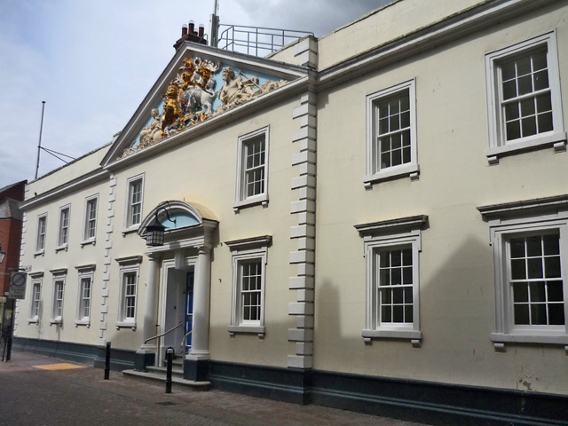
English: Trinity House, Hull Seen from Trinity House Lane, the building dates from 1753. Founded in 1369 as a religious guild, from the 16th century Trinity House became the authority in charge of navigation, pilotage and buoys on the Humber. It subsequently acquired much property in the city and became a strong influence on its government and expansion. Its nautical school opened in 1786. |
| Date | 2009-05-10 |
| Source | From geograph.org.uk |
| Author | Paul Harrop |
| ⧼wm-license-information-permission⧽ (⧼wm-license-information-permission-reusing-text⧽) |
Creative Commons Attribution Share-alike license 2.0 |
| ⧼wm-license-cc-attribution⧽ (قالب:I18n/Credit line) |
Paul Harrop / Trinity House, Hull / |
53°44′32″N 0°20′05″W / 53.74233°N 0.3346°W
_heading:247)
| Object location | ملف:Compass-icon bb WSW.svg | View all coordinates using: OpenStreetMap |
|---|
_heading:247.00&language=⧼lang⧽)
ترخيص
تاريخ الملف
اضغط على زمن/تاريخ لرؤية الملف كما بدا في هذا الزمن.
| زمن/تاريخ | صورة مصغرة | الأبعاد | مستخدم | تعليق | |
|---|---|---|---|---|---|
| حالي | ★ مراجعة معتمدة 22:07، 3 ديسمبر 2023 | | 640 × 480 (156 كيلوبايت) | Pastakhov (نقاش | مساهمات) | Upload https://upload.wikimedia.org/wikipedia/commons/d/d9/Trinity_House%2C_Hull_-_geograph.org.uk_-_1296344.jpg |
لا يمكنك استبدال هذا الملف.
وصلات
لا يوجد صفحات تصل لهذه الصورة.
معلومات الصورة (ميتا)
تصنيفات:
- Pages using gadget WikiMiniAtlas
- Trinity House, Kingston upon Hull
- Reliefs of coats of arms in the East Riding of Yorkshire
- Reliefs of the Royal coats of arms of the United Kingdom in the United Kingdom
- Colorful reliefs in England
- Colorful reliefs of coats of arms
- Coats of arms in pediments
- May 2009 in Kingston upon Hull
- Images by Paul Harrop
- United Kingdom photographs taken on 2009-05-10
- صفحات مع الخرائط